- M'Goun
-
M'Goun 
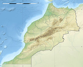
Ighil M'GounElevation 4,071 m (13,356 ft) Prominence 1,904 m (6,247 ft) Listing Ultra Location Souss-Massa-Draâ, Morocco Range High Atlas Range Coordinates 31°30′36″N 6°26′24″W / 31.51°N 6.44°WCoordinates: 31°30′36″N 6°26′24″W / 31.51°N 6.44°W The M'Goun mountain, also rendered as Ighil Mgoun, Ighil n’Oumsoud, Irhil M’Goun, Ighil M’Goun, Jebel Mgoun, Jebel Ighil M’Goun and Jebel Aït M’goun, at 4,071 metres (13,356 ft) is the fourth highest peak of the Atlas Mountains (After Toubkal, Timzguida and Ouenkrim). It is located in the Souss-Massa-Draâ region of Morocco.
References
 Mountains of Morocco
High Atlas Toubkal (4,167 m/13,671 ft) • Ouanoukrim (4,089 m/13,415 ft) • Ighil M'Goun (4,071 m/13,356 ft) • Tazarhart (3,995 m/13,107 ft) • Aksoual (3,910 m/12,828 ft) • Ineghmar (3,892 m/12,769 ft) • Bou Iguenwan (3,882 m/12,736 ft) • Uwawgulzat (3,763 m/12,346 ft) • Tichki (3,753 m/12,313 ft) • Ayachi (3,747 m/12,293 ft) • Azrou Tamadout (3,664 m/12,021 ft) • Oukaimeden (3,200 m/10,499 ft) • Saghro (2,592 m/8,504 ft) • Tassemit (2,247 m/7,372 ft)
Middle Atlas Bou Naceur (3,356 m/11,010 ft) • Mouasker (3,277 m/10,751 ft) • Bou Iblan (3,172 m/10,407 ft) • Tanourdi (2,250 m/7,382 ft)
Anti-Atlas Sirwa (3,304 m/10,840 ft) • Amalou-n-Mansour (2,712 m/8,898 ft) • Imgout (2,530 m/8,301 ft)
Saharan Atlas Grouz (1,888 m/6,194 ft)
Rif Tidirhine (2,456 m/8,058 ft) • Gourougou (900 m/2,953 ft)
Other Jbel Lakhdar (893 m/2,930 ft) • JBel Musa (851 m/2,792 ft) •
Categories:- Mountains of Morocco
- Morocco geography stubs
Wikimedia Foundation. 2010.

