- Ouanoukrim
-
Ouanoukrim
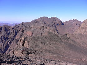
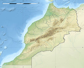
The Ouenoukrim mountain as seen from Toubkal. The Timzguida summit is left and Ras Ouanoukrim rightElevation 4,089 m (13,415 ft) [1][2] Listing Ultra Location Souss-Massa-Draâ, Morocco Range High Atlas Range Coordinates 31°02′11″N 7°56′50″W / 31.03639°N 7.94722°WCoordinates: 31°02′11″N 7°56′50″W / 31.03639°N 7.94722°W Ouanoukrim (also Ouenkrim) is a mountain in Morocco located south of Marrakesh. It has two summits, Timzguida (4,089 m/13,415 ft) and Ras Ouanoukrim (4,083 m/13,396 ft) which are the second and third highest peaks of the Atlas range.[1][2]
References
- ^ a b "Jebel Ouanoukrim, Morocco". http://www.peakbagger.com/peak.aspx?pid=11044. Retrieved 13 November 2011.
- ^ a b "Ouanoukrim". http://www.summitpost.org/ouanoukrim/151041. Retrieved 13 November 2011.
 Mountains of Morocco
High Atlas Toubkal (4,167 m/13,671 ft) • Ouanoukrim (4,089 m/13,415 ft) • Ighil M'Goun (4,071 m/13,356 ft) • Tazarhart (3,995 m/13,107 ft) • Aksoual (3,910 m/12,828 ft) • Ineghmar (3,892 m/12,769 ft) • Bou Iguenwan (3,882 m/12,736 ft) • Uwawgulzat (3,763 m/12,346 ft) • Tichki (3,753 m/12,313 ft) • Ayachi (3,747 m/12,293 ft) • Azrou Tamadout (3,664 m/12,021 ft) • Oukaimeden (3,200 m/10,499 ft) • Saghro (2,592 m/8,504 ft) • Tassemit (2,247 m/7,372 ft)
Middle Atlas Bou Naceur (3,356 m/11,010 ft) • Mouasker (3,277 m/10,751 ft) • Bou Iblan (3,172 m/10,407 ft) • Tanourdi (2,250 m/7,382 ft)
Anti-Atlas Sirwa (3,304 m/10,840 ft) • Amalou-n-Mansour (2,712 m/8,898 ft) • Imgout (2,530 m/8,301 ft)
Saharan Atlas Grouz (1,888 m/6,194 ft)
Rif Tidirhine (2,456 m/8,058 ft) • Gourougou (900 m/2,953 ft)
Other Jbel Lakhdar (893 m/2,930 ft) • JBel Musa (851 m/2,792 ft) •
Categories:- Mountains of Morocco
- Morocco geography stubs
Wikimedia Foundation. 2010.


