- Markham, Washington
-
Markham, Washington — CDP — Location of Markham, Washington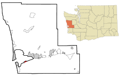
Coordinates: 46°54′47″N 123°59′7″W / 46.91306°N 123.98528°WCoordinates: 46°54′47″N 123°59′7″W / 46.91306°N 123.98528°W Country United States State Washington County Grays Harbor Area – Total 1.1 sq mi (2.9 km2) – Land 1.1 sq mi (2.9 km2) – Water 0.0 sq mi (0.0 km2) Elevation 23 ft (7 m) Population (2010) – Total 111 – Density 84.6/sq mi (32.7/km2) Time zone Pacific (PST) (UTC-8) – Summer (DST) PDT (UTC-7) ZIP code 98520 Area code(s) 360 FIPS code 53-43640[1] GNIS feature ID 1511125[2] Markham is a census-designated place (CDP) in Grays Harbor County, Washington, United States. The population was 111 at the 2010 census.
Geography
Markham is located at 46°54′47″N 123°59′07″W / 46.913041°N 123.985296°W (46.913041, -123.985296).[3]
According to the United States Census Bureau, the CDP has a total area of 1.1 square miles (2.9 km2), all of it land.
Demographics
Historical populations Census Pop. %± 2000 95 — 2010 111 16.8% U.S. Decennial Census As of the census[1] of 2000, there were 95 people, 41 households, and 30 families residing in the CDP. The population density was 84.6 people per square mile (32.7/km2). There were 51 housing units at an average density of 45.4/sq mi (17.6/km2). The racial makeup of the CDP was 94.74% White, 1.05% Native American, 2.11% Asian, 1.05% from other races, and 1.05% from two or more races. Hispanic or Latino of any race were 2.11% of the population.
There were 41 households out of which 17.1% had children under the age of 18 living with them, 65.9% were married couples living together, 4.9% had a female householder with no husband present, and 26.8% were non-families. 19.5% of all households were made up of individuals and 2.4% had someone living alone who was 65 years of age or older. The average household size was 2.32 and the average family size was 2.67.
In the CDP the population was spread out with 12.6% under the age of 18, 6.3% from 18 to 24, 22.1% from 25 to 44, 47.4% from 45 to 64, and 11.6% who were 65 years of age or older. The median age was 48 years. For every 100 females there were 115.9 males. For every 100 females age 18 and over, there were 107.5 males.
The median income for a household in the CDP was $63,750, and the median income for a family was $96,816. Males had a median income of $40,625 versus $23,750 for females. The per capita income for the CDP was $23,700. There were no families and 12.3% of the population living below the poverty line, including no under eighteens and 100.0% of those over 64.
References
- ^ a b "American FactFinder". United States Census Bureau. http://factfinder.census.gov. Retrieved 2008-01-31.
- ^ "US Board on Geographic Names". United States Geological Survey. 2007-10-25. http://geonames.usgs.gov. Retrieved 2008-01-31.
- ^ "US Gazetteer files: 2010, 2000, and 1990". United States Census Bureau. 2011-02-12. http://www.census.gov/geo/www/gazetteer/gazette.html. Retrieved 2011-04-23.
Municipalities and communities of Grays Harbor County, Washington Cities Aberdeen | Cosmopolis | Elma | Hoquiam | McCleary | Montesano | Oakville | Ocean Shores | Westport
CDPs Aberdeen Gardens | Brady | Central Park | Chehalis Village | Cohassett Beach | Copalis Beach | Grayland | Humptulips | Junction City | Malone-Porter | Markham | Moclips | Neilton | Ocean City | Oyehut-Hogans Corner | Satsop | Taholah
Unincorporated
communitiesAmanda Park | Copalis Crossing | Pacific Beach | Quinault
Indian reservations Chehalis Indian Reservation‡ | Quinault Indian Reservation‡
Footnotes ‡This populated place also has portions in an adjacent county or counties
Categories:- Populated places in Grays Harbor County, Washington
- Census-designated places in Washington (state)


Wikimedia Foundation. 2010.