- Pentress, West Virginia
-
Pentress — Census-designated place — Location within the state of West Virginia
 Pentress
Coordinates: 39°42′37″N 80°9′37″W / 39.71028°N 80.16028°WCoordinates: 39°42′37″N 80°9′37″W / 39.71028°N 80.16028°W Country United States State West Virginia County Monongalia Area[1] – Total 0.609 sq mi (1.6 km2) – Land 0.606 sq mi (1.6 km2) – Water 0.003 sq mi (0 km2) Population (2010)[2] – Total 175 – Density 287.4/sq mi (110.9/km2) Time zone Eastern (EST) (UTC-5) – Summer (DST) EDT (UTC-4) ZIP codes 26544 FIPS code GNIS feature ID Pentress is an unincorporated census-designated place in northern Monongalia County, West Virginia, United States. It lies along West Virginia Route 7 northwest of the city of Morgantown, the county seat of Monongalia County.[3] Its elevation is 951 feet (290 m). "Pentress" is not the only name the community has had; at various times in its history, it has been known as Minors Mills, New Brownsville, Pentrees, Pentress Junction, Statler Town, Statlers Town, Statlersville, and Stradlerstown.[4] Although it is unincorporated, it has a post office, with the ZIP code of 26544.[5] As of the 2010 census, its population was 175.[2]
References
- ^ "US Gazetteer files: 2010, 2000, and 1990". United States Census Bureau. 2011-02-12. http://www.census.gov/geo/www/gazetteer/gazette.html. Retrieved 2011-04-23.
- ^ a b "American FactFinder". United States Census Bureau. http://factfinder2.census.gov. Retrieved 2011-05-14.
- ^ Rand McNally. The Road Atlas '08. Chicago: Rand McNally, 2008, p. 112.
- ^ Geographic Names Information System Feature Detail Report, Geographic Names Information System, 1980-06-27. Accessed 2008-03-29.
- ^ Zip Code Lookup
Municipalities and communities of Monongalia County, West Virginia Cities 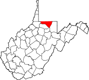
Towns CDPs Brookhaven | Cassville | Cheat Lake | Pentress
Other
localitiesArnettsville | Baker Ridge | Behler | Bertha Hill | Booth | Bowlby | Browns Chapel | Bula | Canyon | Cheat Neck | Chestnut Ridge | Clinton Furnace | Core | Crossroads | Crown | Daybrook | Dellslow | Delmar | Easton | Edna | Everettsville | Fieldcrest | Flaggy Meadow | Fort Grand | Fort Martin | Georgetown | Greer | Greystone | Gum Spring | Hagans | Halleck | Harmony Grove | Hilderbrand | Hoard | Hog Eye | Holman | Hunting Hills | Jaco | Jakes Run | Jere | Kimberly | Klondike | Laurel Point | Little Falls | Lowsville | Macdale | Maidsville | Maple | McCurdyville | McMellin | Miracle Run | Mooresville | Morgan Heights | National | New Hill | Opekiska | Osage | Osgood | Pedlar | Pierpont | Pioneer Rocks | Price | Price Hill | Pursglove | Ragtown | Randall | Richard | Ridgedale | Ringgold | Rock Forge | Rosedale | Sabraton | Saint Cloud | Saint Leo | Sandy | Smithtown | Stewartstown | Suncrest Lake | Sunset Beach | Sturgisson | The Mileground | Triune | Tyrone | Uffington | Van Voorhis | Wadestown | Wana | West Sabraton | West Van Voorhis | Worley
Categories:- Mountaineer Country geography stubs
- Populated places in Monongalia County, West Virginia
- Census-designated places in West Virginia


Wikimedia Foundation. 2010.