- Charles River Dam Bridge
-
- Not to be confused with the 1786 Charles River Bridge at the site of the current Charlestown Bridge, nor the current Charles River Dam built in 1978 at the site of the 1828 Warren Bridge.
Charles River Dam Bridge Carries six lanes of traffic (Route 28), two sidewalks Crosses Charles River at mile 1.0 Locale Boston, Massachusetts Maintained by Massachusetts Department of Conservation and Recreation ID number 160134 Design steel bascule bridge Total length 25.0 m (82.0 ft) Width 25.6 m (84.0 ft) Longest span 19.2 m (63.0 ft) Clearance below 4.6 m (15 ft) Opened 1910 Coordinates 42°22′05″N 71°04′15″W / 42.3680°N 71.0708°WCoordinates: 42°22′05″N 71°04′15″W / 42.3680°N 71.0708°W 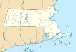

The Charles River Dam Bridge, officially the Craigie Bridge[1] , also called Craigie's Bridge or the Canal Bridge, is a six-lane bascule bridge across the Charles River, connecting Leverett Circle in downtown Boston, to Monsignor O'Brien Highway in East Cambridge, Massachusetts. The bridge, maintained by the Massachusetts Department of Conservation and Recreation (DCR, formerly the MDC), carries Route 28 next to the Green Line's Lechmere Viaduct. The bridge is fully within Boston, with the city line to the north, at the center of the original river. The Museum of Science is located on the dam and nearby piers.
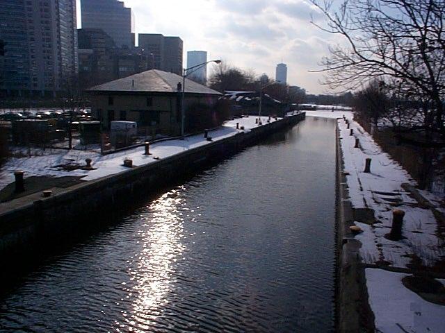
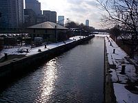 Photo of the original lock for the Charles River in Boston, Massachusetts as bordered by Nashua Street Park on the south and Charles Hayden Planetarium to the north and positioned just west of the Charles River Dam Bridge.
The original lock for the Charles River was just west of the Charles River Dam Bridge, but the lock services was relocated east to the Charles River Dam and incorporated as three parallel locks on the site of the old Warren Bridge.
The former lock at the Charles River Dam Bridge now allows water and small ships to flow freely. Taller ships require the opening of the drawbridge, operated by the Massachusetts Department of Transportation.
Contents
History
The first bridge on the site was known as the Canal Bridge, named after the Middlesex Canal which ran from the Charlestown Mill Pond to Middlesex Village in East Chelmsford Massachusetts; later p/o Lowell.[2] (It was not named after the short Lechmere Canal which is now near the Cambridge side of the bridge, but did not exist at the time.) As an investment, businessman Andrew Craigie purchased the largely undeveloped farmland on the Cambridge side around Lechmere Point from various owners (including Mary Lechmere and heirs) in preparation for building the bridge. The investors incorporated in 1807 with a charter to build a bridge from Leverett Street in the West End, Boston to the eastern end of Lechmere Point. One-third of shares were owned by the Middlesex Canal Corporation.[3]
The bridge opened in 1809, and came to be known as Craigie's Bridge. The construction of the bridge prompted the laying out of roads to the center of Cambridge (now Cambridge Street, running to Harvard Square) and Somerville/Medford (Bridge Street, now Monsignor O'Brien Highway/Massachusetts Route 28). Craigie and associates, who formed the Lechemere Point Corporation, benefited from the building boom that followed, spurred on by their efforts to expand the public street grid.[4] Residential cross streets were constructed and some were named after investors (Otis, Thorndike, and Gore)[5][6] The bridge was sold to the Hancock Free Bridge Corporation in 1846,[7] and became toll-free on January 30, 1858.[8]
The current bridge was constructed in 1910, along with the dam that turned the lower Charles River from a tidal estuary into a fresh-water basin. It was completed on June 30, and greeted with a two-hour fireworks display that Fourth of July. Thousands of people watching from the new Boston Embankment (the early Charles River Esplanade) which took the place of the former tidal flats.[9]
Construction of the Museum of Science began on the dam in 1948, and finished in 1951.
2010-2011 Construction Project
The Massachusetts Department of Transportation is engaged in a 2-year project to rehabilitate the Craigie Bridge and to completely replace the drawbridge. This project will necessitate the closure of the Boston-bound lanes from November 6, 2010 through mid December, 2010, and again from early February, 2011 through mid April, 2011, necessitating traffic detours.[10]
See also
References
- ^ U.S. Coast Pilot, volume 1, Atlantic Coast: Eastport to Cape Cod. NOAA. 2008. p. 69.
- ^ Clark, Mary Stetson; The Old Middlesex Canal; Hilltop Press, Medford MA,1974, p-42
- ^ Publications By Cambridge Historical Society (Mass.)
- ^ Publications, p. 60
- ^ [1] History of Cambridge, Massachusetts. 1630-1877 by Lucius Robinson Paige. p. 183-185.
- ^ http://books.google.com/books?id=hT0VAAAAYAAJ&pg=RA2-PA60&lpg=RA2-PA60&source=bl&ots=PEocW6Jccd&sig=9OMJUv_D4ijWbYIJJwdQWgP07mk&hl=en&ei=nE81Sp79CJuetweCpOTHCQ&sa=X&oi=book_result&ct=result&resnum=2#PRA2-PA53,M1
- ^ Publications, p. 61
- ^ History of Cambridge, p. 201-202
- ^ "100 years of celebrating the Fourth of July at Esplanade". The Boston Globe. 2010-07-04. http://www.boston.com/yourtown/cambridge/articles/2010/07/04/100_years_of_celebrating_the_fourth_of_july_at_esplanade/. Retrieved 2010-08-11.
- ^ [2] Mass DOT Craigie Dam/Craigie Bridge Project
Crossings of the Charles River Upstream
Longfellow Bridge

Charles River Dam Bridge

Downstream
Lechmere Viaduct
MBTA Green LineCategories:- Bascule bridges
- Bridges in Boston, Massachusetts
- Dams in Massachusetts
- Bridges completed in 1810
- Bridges completed in 1910
- Buildings and structures in Boston, Massachusetts
- Road bridges in Massachusetts

Wikimedia Foundation. 2010.