- Darrouzett, Texas
-
Darrouzett, Texas — Town — Location of Darrouzett, Texas
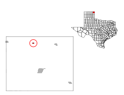
Coordinates: 36°26′40″N 100°19′35″W / 36.44444°N 100.32639°WCoordinates: 36°26′40″N 100°19′35″W / 36.44444°N 100.32639°W Country United States State Texas County Lipscomb Area – Total 0.4 sq mi (1.0 km2) – Land 0.4 sq mi (1.0 km2) – Water 0.0 sq mi (0.0 km2) Elevation 2,556 ft (779 m) Population (2000) – Total 303 – Density 809.7/sq mi (312.6/km2) Time zone Central (CST) (UTC-6) – Summer (DST) CDT (UTC-5) ZIP code 79024 Area code(s) 806 FIPS code 48-19288[1] GNIS feature ID 1355657[2] Darrouzett is a town in Lipscomb County, Texas, United States. The population was 303 at the 2000 census. The town is named for John Louis Darrouzet, a Texas state legislator who served as an attorney for the Santa Fe Railroad.
Contents
Geography
Darrouzett is located at 36°26′40″N 100°19′35″W / 36.44444°N 100.32639°W (36.444544, -100.326487)[3].
According to the United States Census Bureau, the town has a total area of 0.4 square miles (1.0 km2), all of it land.
Demographics
As of the census[1] of 2000, there were 303 people, 137 households, and 84 families residing in the town. The population density was 809.7 people per square mile (316.2/km²). There were 182 housing units at an average density of 486.3 per square mile (189.9/km²). The racial makeup of the town was 91.75% White, 0.66% African American, 0.66% Native American, 2.64% from other races, and 4.29% from two or more races. Hispanic or Latino of any race were 9.24% of the population.
There were 137 households out of which 23.4% had children under the age of 18 living with them, 54.7% were married couples living together, 3.6% had a female householder with no husband present, and 38.0% were non-families. 36.5% of all households were made up of individuals and 20.4% had someone living alone who was 65 years of age or older. The average household size was 2.21 and the average family size was 2.89.
In the town the population was spread out with 25.4% under the age of 18, 4.0% from 18 to 24, 22.4% from 25 to 44, 25.7% from 45 to 64, and 22.4% who were 65 years of age or older. The median age was 43 years. For every 100 females there were 94.2 males. For every 100 females age 18 and over, there were 100.0 males.
The median income for a household in the town was $32,625, and the median income for a family was $35,000. Males had a median income of $33,000 versus $19,063 for females. The per capita income for the town was $17,237. About 9.4% of families and 11.3% of the population were below the poverty line, including 12.0% of those under the age of eighteen and none of those sixty five or over.
Education
The Town of Darrouzett is served by the Darrouzett Independent School District.
References
- ^ a b "American FactFinder". United States Census Bureau. http://factfinder.census.gov. Retrieved 2008-01-31.
- ^ "US Board on Geographic Names". United States Geological Survey. 2007-10-25. http://geonames.usgs.gov. Retrieved 2008-01-31.
- ^ "US Gazetteer files: 2010, 2000, and 1990". United States Census Bureau. 2011-02-12. http://www.census.gov/geo/www/gazetteer/gazette.html. Retrieved 2011-04-23.
Municipalities and communities of Lipscomb County, Texas Cities 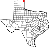
Towns Booker | Darrouzett
CDP Categories:- Populated places in Lipscomb County, Texas
- Towns in Texas


Wikimedia Foundation. 2010.