- Texas State Highway 305
Infobox TX State Highway
type=State
route=305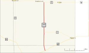
length_mi=29.408
length_ref=TxDOT|SH|305|accessdate=2008-03-14]
length_round=3
formed=by 1939
dir1=South
dir2=North
from=jct|state=TX|US|60
junction=
to=jct|state=TX|SH|15
previous_type=State
previous_route=304
next_type=State
next_route=306State Highway 305 or SH 305 is a Texas state highway that runs from just east of Darrouzett south toe Glazier in the far northeastern
Texas Panhandle . This route was designated by 1939.Route description
SH 305 begins at a junction with US 60 and FM 2758. It heads north from this junction to an intersection with SH 213. The highway continues to the north to an intersection with FM 1920. Heading towards the north, the highway continues to an intersection Spur 108 in Lipscomb. The highway continues to the north to an intersection with FM 2172. SH 305 reaches its northern terminus at SH 15.cite map|publisher=
Google Maps |title=Overview map of SH 305|accessdate=2008-03-14|url=http://maps.google.com/maps?f=d&hl=en&geocode=3163830499098855037,36.011280,-100.264010%3B12373881370595178298,36.434972,-100.275869&saddr=TX-305+%4036.011280,+-100.264010&daddr=TX-305+%4036.434972,+-100.275869&doflg=ptm&sll=36.223125,-100.2703&sspn=0.582734,1.496887&ie=UTF8&z=10]Junction list
References

Wikimedia Foundation. 2010.