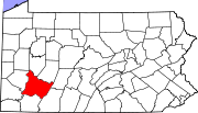
Crabtree, Pennsylvania

Crabtree, Pennsylvania
Crabtree
—  CDP  —
Crabtree is located in Pennsylvania
Crabtree
Location within the state of Pennsylvania
Coordinates: 40°21′48″N 79°28′11″W / 40.36333°N 79.46972°W / 40.36333; -79.46972Coordinates: 40°21′48″N 79°28′11″W / 40.36333°N 79.46972°W / 40.36333; -79.46972
Country United States
State Pennsylvania
County Westmoreland
Area
 – Total 0.1 sq mi (0.3 km2)
 – Land 0.1 sq mi (0.3 km2)
Population (2000)
 – Total 320
 – Density 2,762.7/sq mi (1,066.7/km2)
Time zone Eastern (EST) (UTC-5)
 – Summer (DST) EDT (UTC-4)
ZIP codes
FIPS code
GNIS feature ID

Crabtree is a census-designated place (CDP) in Salem Township, Westmoreland County, Pennsylvania, United States. The population was 320 at the 2000 census.

Geography

Crabtree is located at 40°21′48″N 79°28′11″W / 40.36333°N 79.46972°W / 40.36333; -79.46972 (40.363400, -79.469664)[1].

According to the United States Census Bureau, the CDP has a total area of 0.1 square miles (0.26 km2), all of it land.

Demographics

As of the census[2] of 2000, there were 320 people, 147 households, and 98 families residing in the CDP. The population density was 3,234.8 people per square mile (1,235.5/km²). There were 160 housing units at an average density of 1,617.4/sq mi (617.8/km²). The racial makeup of the CDP was 99.06% White and 0.94% African American.

There were 147 households out of which 19.7% had children under the age of 18 living with them, 51.0% were married couples living together, 8.8% had a female householder with no husband present, and 33.3% were non-families. 29.3% of all households were made up of individuals and 18.4% had someone living alone who was 65 years of age or older. The average household size was 2.16 and the average family size was 2.61.

In the CDP the population was spread out with 15.9% under the age of 18, 5.3% from 18 to 24, 27.2% from 25 to 44, 22.5% from 45 to 64, and 29.1% who were 65 years of age or older. The median age was 46 years. For every 100 females there were 101.3 males. For every 100 females age 18 and over, there were 100.7 males.

The median income for a household in the CDP was $28,676, and the median income for a family was $33,804. Males had a median income of $28,000 versus $17,009 for females. The per capita income for the CDP was $18,613. About 5.3% of families and 5.9% of the population were below the poverty line, including none of those under age 18 and 8.6% of those age 65 or over.

References

  1. ^ "US Gazetteer files: 2010, 2000, and 1990". United States Census Bureau. 2011-02-12. http://www.census.gov/geo/www/gazetteer/gazette.html. Retrieved 2011-04-23. 
  2. ^ "American FactFinder". United States Census Bureau. http://factfinder.census.gov. Retrieved 2008-01-31. 

Wikimedia Foundation. 2010.

Игры ⚽ Нужен реферат?

Look at other dictionaries:

  • Crabtree — ist der Familienname folgender Personen: Arthur Crabtree (1900–1975), britischer Kameramann und Filmregisseur Gerald Crabtree (* 1946), US amerikanischer Zellbiologe Herbert Grace Crabtree, englischer Biochemiker Jane Crabtree (* 1981),… …   Deutsch Wikipedia

  • Crabtree — may refer to: Contents 1 People 2 Places 3 Companies 4 Science 5 Plants …   Wikipedia

  • Crabtree — Crabtree, PA U.S. Census Designated Place in Pennsylvania Population (2000): 320 Housing Units (2000): 160 Land area (2000): 0.098925 sq. miles (0.256214 sq. km) Water area (2000): 0.000000 sq. miles (0.000000 sq. km) Total area (2000): 0.098925… …   StarDict's U.S. Gazetteer Places

  • Crabtree, PA — U.S. Census Designated Place in Pennsylvania Population (2000): 320 Housing Units (2000): 160 Land area (2000): 0.098925 sq. miles (0.256214 sq. km) Water area (2000): 0.000000 sq. miles (0.000000 sq. km) Total area (2000): 0.098925 sq. miles… …   StarDict's U.S. Gazetteer Places

  • Crabtree Creek — may refer to one of these streams: Crabtree Creek (Neuse River), in the U.S. state of North Carolina Crabtree Creek (South Santiam River), in the U.S. state of Oregon There are also streams named Crabtree Creek in the U.S. states of Arizona,… …   Wikipedia

  • List of Pennsylvania locations by per capita income — Pennsylvania locations by per capita income is a list of all incorporated areas and census designated places in Pennsylvania ranked from highest capita income to lowest per capita income. There are many communities not on the list because they… …   Wikipedia

  • Don Crabtree — (June 8, 1912 – November 16, 1980) was a flintknapper and pioneering experimental archaeologist. Known as the “Dean of American flintknappers” he was mostly self educated, however he was awarded an honorary doctorate degree by the University of… …   Wikipedia

  • Levittown, Pennsylvania — Geobox Settlement name = Levittown native name = other name = other name1 = category = Census designated place image size = image caption = Aerial view of Levittown, Pennsylvania circa 1959 flag size = symbol = symbol size = nickname = motto =… …   Wikipedia

  • National Register of Historic Places listings in Westmoreland County, Pennsylvania — Location of Westmoreland County This is a list of the National Register of Historic Places listings in Westmoreland County, Pennsylvania. This is intended to be a complete list of the properties and districts on the National Register of Historic… …   Wikipedia

  • Norvelt, Pennsylvania — Coordinates: 40°12′34″N 79°30′13″W / 40.20944°N 79.50361°W / 40.20944; 79.50361 …   Wikipedia

Share the article and excerpts

Direct link
Do a right-click on the link above
and select “Copy Link”