- Mere Brow
-
Coordinates: 53°39′45″N 2°52′48″W / 53.6625°N 2.8800°W
Mere Brow
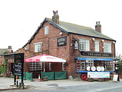
The Legh Arms public house
 Mere Brow shown within Lancashire
Population 5,350 2001 Census (Tarleton Parish) Parish Tarleton District West Lancashire Shire county Lancashire Region North West Country England Sovereign state United Kingdom Post town PRESTON Postcode district PR Police Lancashire Fire Lancashire Ambulance North West EU Parliament North West England UK Parliament South Ribble List of places: UK • England • Lancashire Mere Brow is a small village in Lancashire, England, situated between Tarleton and Banks, just off the A565 road. It is 6 miles (9 km) east of Southport and 10 miles (15 km) south west of Preston. It is administered by the West Lancashire District Council and the Tarleton parish council.[1] It is in the South Ribble parliamentary constituency. Mere Brow is the second largest village in the parish of Tarleton, the largest being Tarleton and the smallest being Holmes and Sollom.
Contents
History
Mere Brow and the neighbouring village of Holmes were part of the ancient parish of North Meols but now are part of Tarleton parish. The name Mere Brow is believed to have come from the time when it was the most northerly settlement on Martin Mere.
Economy
Like most settlements in the area, it was primarily an agricultural village thanks to the excellent soil, although there was fishing activity for many years. Production of flowers and vegetables is still common on the farms around the village.
Amenities
Facilities in the village include a pub, a smithy, the village hall, general store, animal feed merchants and the leisure lakes. The Post Office closed in 2008 and the nearest is in Banks. The village bank closed in the mid 1990s and is now a residential dwelling.
The local hospitals are Southport District General Hospital and Ormskirk District General Hospital, the nearest GP surgery is in Tarleton.[2]
Education
Mere Brow Church of England Primary School was founded in 1847 as a National school providing free education.[3] The school is associated with Holy Trinity Church in Tarleton and has been expanded on numerous occasions since it first opened to meet the increased demands as the village grew. As of 2010 the school had 52 pupils in 2010.[4] Secondary age pupils attend Tarleton High School or Bishop Rawstorne C of E Language College.
Religion
Mere Brow Methodist Church was opened in 1902. Before it was built, the tin roofed cottage next to it was used for worship.[5] St Mary's Church, Tarleton was the nearest Church of England church until Holy Trinity was opened in 1888.[6]
Community
The village has held a giant pumpkin competition in October for 16 years.[7]
Geography

Banks Hundred End Tarleton 
North Meols 
Holmes  Mere Brow

Scarisbrick Holmeswood Rufford External links
References
- ^ Local Governance, Tarleton Parish Council, http://www.tarletonpc.co.uk/page1results.asp?PCL1ID=661, retrieved 2011-03-19
- ^ Tarleton Group Practice (2006) "Home page - Welcome to Tarleton Group Practice", http://www.tarletongrouppractice.nhs.uk/
- ^ Lancashire Villages (2001-2010) "Mere Brow - Mere Brow Church of England Primary School", http://www.merebrow.com/history/earthfloors/school.html
- ^ Ofsted (2010) "Tarleton Mere Brow, Church of England Primary School", http://www.ofsted.gov.uk/oxedu_providers/full/(urn)/119574/(type)/4096,2048/(typename)/Nursery%20and%20primary%20education
- ^ Lancashire Villages, (2001-2006) "Mere Brow - Methodism in Mere Brow", http://www.merebrow.com/chapel/centenary.html
- ^ Lancashire Villages (2001-2010) "St Mary's Old Church, Tarleton", http://www.heskethbank.com/home/stmarys/index.html
- ^ Mere Brow Village, (2001-2010) "Mere Brow Giant Pumpkins", http://www.merebrow.com/home/mbgp/
Coordinates: 53°39′43″N 2°52′57″W / 53.6619°N 2.8824°W
Categories:- Villages in Lancashire
- Geography of West Lancashire
- Lancashire geography stubs
Wikimedia Foundation. 2010.


