Meythet

Meythet

Meythet

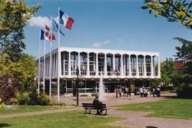
Mairie meythet A 28avril02.jpg
Vue de la mairie de Meythet
Meythet is located in France
{{{alt}}}
Meythet
Administration
Country France
Region Rhône-Alpes
Department Haute-Savoie
Arrondissement Annecy
Canton Annecy-Nord-Ouest
Intercommunality Communauté de l'agglomération d'Annecy
Mayor Sylvie Gillet de Thorey
(2008–2014)
Statistics
Elevation 411–460 m (1,348–1,510 ft)
Land area1 3.24 km2 (1.25 sq mi)
Population2 8,400  (2006)
 - Density 2,593 /km2 (6,720 /sq mi)
INSEE/Postal code 74182/ 74960
Website www.mairie-meythet.fr
1 French Land Register data, which excludes lakes, ponds, glaciers > 1 km² (0.386 sq mi or 247 acres) and river estuaries.
2 Population without double counting: residents of multiple communes (e.g., students and military personnel) only counted once.

Coordinates: 45°54′56″N 6°05′37″E / 45.9155555556°N 6.09361111111°E / 45.9155555556; 6.09361111111

Meythet is a commune in the Haute-Savoie department in the Rhône-Alpes region in south-eastern France.

Geography

The Fier forms most of the commune's south-eastern border.

See also

References


Wikimedia Foundation. 2010.

Игры ⚽ Поможем написать реферат

Look at other dictionaries:

  • Meythet — Meythet …   Deutsch Wikipedia

  • Meythet — Meythet …   Wikipedia Español

  • Meythet — 45° 54′ 56″ N 6° 05′ 37″ E / 45.9155555556, 6.09361111111 …   Wikipédia en Français

  • Meythet — Original name in latin Meythet Name in other language Meithet, Meythet State code FR Continent/City Europe/Paris longitude 45.91836 latitude 6.09422 altitude 451 Population 8538 Date 2012 01 18 …   Cities with a population over 1000 database

  • Aeroport d'Annecy - Meythet — Aéroport d Annecy Meythet 45°55′46″N 6°5′55″E / 45.92944, 6.09861 …   Wikipédia en Français

  • Aéroport d'Annecy - Meythet — 45°55′46″N 6°5′55″E / 45.92944, 6.09861 …   Wikipédia en Français

  • Société intercommunale des bus de la région annécienne — Logo de la Société intercommunale des bus de la région annécienne Création 1980 …   Wikipédia en Français

  • Sibra — Société intercommunale des bus de la région annécienne Logo de la Société intercommunale des bus de la région annécienne Création 1980 …   Wikipédia en Français

  • Societe intercommunale des bus de la region annecienne — Société intercommunale des bus de la région annécienne Logo de la Société intercommunale des bus de la région annécienne Création 1980 …   Wikipédia en Français

  • Annecy — 45° 54′ 58″ N 6° 07′ 59″ E / 45.916, 6.133 …   Wikipédia en Français

Share the article and excerpts

Direct link
Do a right-click on the link above
and select “Copy Link”