Medway Navigation

Medway Navigation
Medway Navigation
Legend
Unknown BSicon "ueGRENZE"
-- River MedwayTidal
Unknown BSicon "uLock3"
0 Allington Lock
Waterway with marina/wharf on left
Allington Marina
Continuation to left Waterway under railway bridge Continuation to right
Maidstone East Line
Waterway under major road
St Peter's Bridge-A20, Maidstone
Waterway under major road
Maidstone Bridge-A20, Maidstone
Urban straight track
College Lock (removed)
Waterway with unused branch to left
River Len
Waterway under minor road
Tovil Foot Bridge
Waterway with unused branch to left
Loose Stream
Unknown BSicon "uLock3"
7.2 Farleigh Lock
Waterway under minor road
Farleigh Bridge
Waterway under minor road
Barming Bridge
Waterway under minor road
Teston Bridge
Unknown BSicon "uLock3"
10.4 Teston Lock
Waterway under minor road
Bow Bridge, Wateringbury
Waterway with unused branch to right
Wateringbury Stream
Waterway turning from left Unknown BSicon "uABZrf"
Waterway with marina/wharf on left Urban straight track
Hampstead Marina
Unknown BSicon "uLock3" Urban straight track
15.2 Hampstead Lane Lock
Urban straight track Waterway with marina/wharf on right
Breden's Boatyard
Urban straight track Waterway with unused branch to left
River Beult
Urban straight track Waterway under minor road
Twyford Bridge, Yalding
Urban straight track Waterway with unused branch to left
River Teise
Unknown BSicon "uLIFT" Urban straight track
Urban straight track Unused waterway weir with flow ahead
5.5 Automatic Sluice
Waterway turning to left Unknown BSicon "uABZlg"
Hampstead Lane Canal
Urban straight track
Stoneham Old Lock (disused)
Continuation to left Waterway under railway bridge Continuation to right
Medway Valley Line
Waterway under major road
A228 East Peckham By-pass
Unused waterway turning from left Waterway with unused branch to right
Unused waterway under minor road Waterway under minor road
Branbridges
Unused straight waterway Unknown BSicon "uLock3"
18.8 Sluice Wier Lock
Unused waterway turning left Unknown BSicon "ueABZlg"
Waterway with unused branch to right
River Bourne
Waterway under minor road
Stilstead Bridge
Unknown BSicon "uLock3"
20.8 Oak Weir Lock
Waterway under minor road
Ford Green Bridge
Unknown BSicon "uLock3"
22.0 East Lock
Unknown BSicon "uLock3"
24.0 Porters Lock
Waterway under minor road
Hartlake Bridge
Unknown BSicon "uLock3"
25.6 Eldridge Lock
Waterway with unused branch to left Unused waterway turning from right
Botany Stream
Waterway under minor road Unused waterway under minor road
28 Cannon Bridge
Unknown BSicon "uLock3" Unused straight waterway
28 Town Lock
Waterway under major road Unused waterway under major road
Big Bridge, Tonbridge A26
Waterway with unused branch to right Unused straight waterway
Hilden Brook
Waterway turning from left Unknown BSicon "uABZrf" Unused straight waterway
Urban straight track Unknown BSicon "uWEIRr" Unused waterway turning right
Waterway turning to left Unknown BSicon "uABZlg"
Continuation to left Waterway under railway bridge Continuation to right
SE Main Line
Unused waterway turning from left Waterway with unused branch to right
Unused straight waterway Waterway under minor road
Lucifer Foot Bridge
Unused straight waterway Waterway under minor road
Sharpe's Bridge
Unknown BSicon "uexGRENZE" Unknown BSicon "uxENDEe"
31 Leigh Barrier
Unused waterway under major road Unused waterway under major road
A21(T)Tonbridge By-pass
Unused waterway turning left Unknown BSicon "uexABZlg"
-- River MedwayUpstream

The River Medway in England flows for 70 miles (113 km) from Turners Hill, in West Sussex, through Tonbridge, Maidstone and the Medway Towns conurbation in Kent, to the River Thames at Sheerness, where it shares the latter's estuary. The Medway Navigation runs from the Leigh Barrier south of Tonbridge to Allington just north of Maidstone. It is 19 miles (31 km) in length. The Environment Agency is the navigation authority responsible for the navigation.

Contents

The route

Until 1746 the river was impassable above Maidstone. To that point each village on the river had its wharf or wharves: at Halling, Snodland, New Hythe and Aylesford. Cargoes included corn, fodder, fruit, stone and timber.

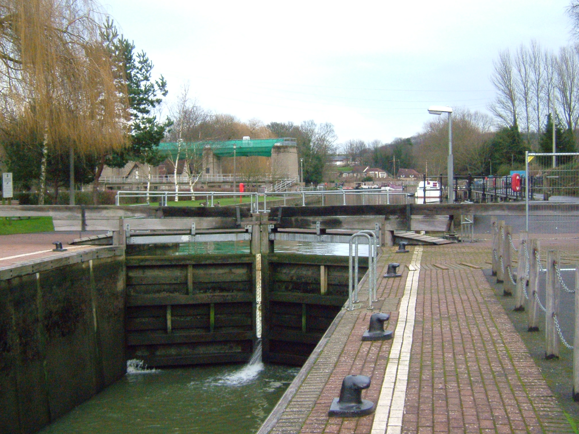
Allington Lock and Sluice, it is at this point that the river becomes tidal.

In 1746 improvements to the channel meant that barges of 40 long tons (41 t) could reach East Farleigh, Yalding and even Tonbridge. The channel was further improved to Leigh in 1828. There are eleven locks on the river. The lowest, opened in 1792, is at Allington, and is the extent of tides. The others are East Farleigh, Teston, Hampstead Lane,Stoneham Old Lock (disused), Sluice Weir Lock, Oak Wier Lock East Lock, Porter's, Eldridge's and Town Lock in Tonbridge. The locks will take craft up to 80 feet (24 m) by 18 feet (5.5 m), and vessels with a draft of 4 feet (1.2 m) can navigate the river. The shallowest point is just below Sluice Weir Lock which is prone to silting after heavy rain.[1]

See also

Moore Bridge.jpg UK Waterways portal

References

  1. ^ The Medway navigation, Leaflet,March 1991, NRA-National Rivers Authority

External links


Wikimedia Foundation. 2010.

Игры ⚽ Нужна курсовая?

Look at other dictionaries:

  • Medway (Fluss) — Medway Flüsse in Kent, mit dem Medway. DatenVorlage:Infobox Fluss/GKZ fehlt …   Deutsch Wikipedia

  • Medway Valley Walk — Joined by the Greensand Way The Twyford Bridge, Yalding, Kent Length 31 kilometres (19 mi) Location South Eastern England, U …   Wikipedia

  • Medway Viaducts — Medway Viaduct Carries Original:4 lanes of M2 plus hard shoulder Bridleway New: 4 lanes of M2 plus hard shoulder Rail: 2 tracks of High Speed 1 Crosses River Medway …   Wikipedia

  • Medway watermills (middle tributaries) — For an explanation of the various pieces of machinery mentioned, see Mill machinery. River Medway (Middle Tributaries) Legend …   Wikipedia

  • Medway watermills diagram — A diagram of the River Medway and its watermills. Due to the size of the diagram it is shown separately to the main article Medway watermills. Watermills of the River Medway and its tributaries Legend …   Wikipedia

  • Navigation authority — A navigation authority is a company or statutory body which is concerned with the management of a navigable canal or river. Contents 1 Rights of a navigation authority 2 Responsibilities of a navigation authority 3 Ownership of the waterway …   Wikipedia

  • River Medway — For similarly named rivers, see Medway River (disambiguation). Coordinates: 51°26′57″N 0°44′18″E / 51.44917°N 0.73833°E / 51.44917; 0.73833 …   Wikipedia

  • List of navigation authorities in the United Kingdom — This List of navigation authorities in the United Kingdom is a list of links to any navigation authority in the United Kingdom, relating to any navigable waterway, aqueduct, canal, navigation, river or port. These include: * narrow canals, broad… …   Wikipedia

  • Thames and Medway Canal — The Thames and Medway Canal is a disused canal in Kent, south east England, also known as the Gravesend and Rochester Canal. It was originally some 11 km (7 miles) long and cut across the neck of the Hoo peninsula, linking the River Thames at… …   Wikipedia

  • General Steam Navigation Company — Die General Steam Navigation Company (GSN) war ein 1824 gegründetes britisches Schifffahrtsunternehmen und eine der ältesten Dampfschifffahrtsgesellschaften der Welt. Sie war 150 Jahre lang Londons vorherrschende Reederei im Kurzliniendienst,… …   Deutsch Wikipedia

Share the article and excerpts

Direct link
Do a right-click on the link above
and select “Copy Link”