- Courmayeur
-
Courmayeur — Comune — Comune di Courmayeur
Commune de CourmayeurCourmayeur 
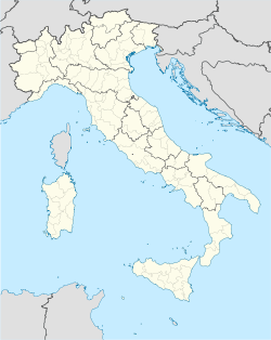
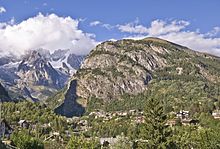
Coat of armsLocation of Courmayeur in Italy Coordinates: 45°47′N 06°58′E / 45.783°N 6.967°ECoordinates: 45°47′N 06°58′E / 45.783°N 6.967°E Country Italy Region Aosta Valley Province none Frazioni Dolonne, Entrèves, La Palud, Villair Dessous, Villair Dessus, Larzey, Entrelevie, La Villette, La Saxe Area – Total 210 km2 (81.1 sq mi) Highest elevation 4,810 m (15,781 ft) Lowest elevation 1,224 m (4,016 ft) Population (2010) – Total 2,870 – Density 13.7/km2 (35.4/sq mi) Demonym Courmayeurins Time zone CET (UTC+1) – Summer (DST) CEST (UTC+2) Postal code 11013 Dialing code 0165 Patron saint St. Pantaleo Saint day July 27 Website Official website Courmayeur is an Italian town and comune in the autonomous region of Aosta Valley, in northern Italy. It is located at the foot of Mont Blanc, the highest mountain in western Europe, in the Graian Alps range, and is crossed by the Dora Baltea. Courmayeur shares the summit of Mont Blanc with its neighboring commune of Chamonix in France, and owns the title of highest commune in Italy.
Tourism
Courmayeur’s picturesque mountain scenery and healthy mountain air make it an attractive destination year round. It is one of Europe’s most famous ski locations, and contains the Giardino Botanico Alpino Saussurea, which describes itself as Europe's highest botanical garden. In the summer months Courmayeur is a popular destination for hikers.
Transport and hiking
Courmayeur is well connected to north-western Italy (220 km from Milan). The Mont Blanc Tunnel links the region to France. Lyon is 240 km away and can be reached in a few hours, and Geneva, Switzerland, is just 100 km away. A regular airport transfer service, door-to-door from Geneva Airport to Courmayeur is operated throughout the ski season by http://www.AostaExpress.com Seats are 48 Euros, each way.
The nearby village of La Palud is the base station of the Funivie Monte Bianco, the cable car to the Pointe Helbronner linking it to the Vallée Blanche Aerial Tramway going to the Aiguille du Midi where there is a link to the Téléphérique de l'Aiguille du Midi, the cable car from Chamonix.
Dolonne, a sister-town of Courmayeur, has many residential areas and hotels, as well as a large sports centre. It is connected to Courmayeur by a bridge that straddles a tributary flowing from Mont Blanc.
Another mountain that surrounds Courmayeur is Mont Chétif. It is a hiker-friendly mountain with a statue of the Virgin Mary at the summit overlooking the town. It can be seen from practically anywhere in Courmayeur.
External links
Comuni of Aosta Valley Allein · Antey-Saint-André · Aosta · Arnad · Arvier · Avise · Ayas · Aymavilles · Bard · Bionaz · Brissogne · Brusson · Challand-Saint-Anselme · Challand-Saint-Victor · Chambave · Chamois · Champdepraz · Champorcher · Charvensod · Châtillon · Cogne · Courmayeur · Donnas · Doues · Emarèse · Etroubles · Fontainemore · Fénis · Gaby · Gignod · Gressan · Gressoney-La-Trinité · Gressoney-Saint-Jean · Hône · Introd · Issime · Issogne · Jovençan · La Magdeleine · La Salle · La Thuile · Lillianes · Montjovet · Morgex · Nus · Ollomont · Oyace · Perloz · Pollein · Pont-Saint-Martin · Pontboset · Pontey · Pré-Saint-Didier · Quart · Rhêmes-Notre-Dame · Rhêmes-Saint-Georges · Roisan · Saint-Christophe · Saint-Denis · Saint-Marcel · Saint-Nicolas · Saint-Oyen · Saint-Pierre · Saint-Rhémy-en-Bosses · Saint-Vincent · Sarre · Torgnon · Valgrisenche · Valpelline · Valsavarenche · Valtournenche · Verrayes · Verrès · VilleneuveCategories:- Cities and towns in Aosta Valley
- Communes of Aosta Valley
- Ski areas and resorts in Italy
Wikimedia Foundation. 2010.


