- California State Route 16
Infobox road
state=CA
type=SR
route=16
section=316
maint=Caltrans 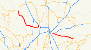
length_mi=111.17
length_ref= [http://www.dot.ca.gov/hq/structur/strmaint/brlog2.htm July 2007 California Log of Bridges on State Highways] ]
length_round=2
length_notes=(includes 28.82 mi (46.38 km) on I-5 and US 50)
established=1934 [http://cahighways.org/009-016.html#016 California Highways: State Route 16] ]
direction_a=West
terminus_a=jct|state=CA|SR|20 near Rumsey
junction=jct|state=CA|I|5 in Woodland----jct|state=CA|US|50 near Sacramento
direction_b=East
terminus_b=jct|state=CA|SR|49 near Drytown
previous_type=SR
previous_route=15
next_type=SR
next_route=17State Route 16 is a
state highway in the northern region of theU.S. state ofCalifornia that runs from Route 20 in Colusa County to Route 49 just outside Plymouth in Amador County. It is discontinuous nearSacramento , being an unsigned route that runs concurrently with both Interstate 5 and U.S. Route 50.This route is part of the
California Freeway and Expressway System [http://www.leginfo.ca.gov/cgi-bin/displaycode?section=shc&group=00001-01000&file=250-257 CA Codes (shc:250-257)] ] and is eligible for the State Scenic Highway System. [http://www.leginfo.ca.gov/cgi-bin/displaycode?section=shc&group=00001-01000&file=260-284 CA Codes (shc:260-284)] ]Route description
Western section
State Route 16 begins in Colusa County near Wilbur Springs at the junction with State Route 20. A few miles south of this terminus, SR 16 enters Yolo County and passes
Cache Creek Canyon Regional Park . SR 16 parallelsCache Creek on its routing from the county line to the end of the western segment. SR 16 then goes through Rumsey, Guinda, Brooks, Capay, Esparto, and Madison, intersecting with County Route E4 and passing by theBlue Cliffs andBald Mountain in the process. East of Madison, SR 16 interchanges with Interstate 505 before heading east toward Woodland. In Woodland, at the junction with County Route E7 southbound, SR 16 turns north and merges with Interstate 5 southbound. Although SR 16 continues on Interstate 5 south to U.S. Route 50, this concurrency is not signed or designated on most maps.Cite map | publisher=Thomas Brothers | title=California Road Atlas and Driver's Guide | year=2000 | page=32,33,39,40] Cite map | publisher = Rand McNally | title = The Road Atlas | year = 2008 | page = 12,13 ]Eastern section
The eastern segment of SR 16 begins at U.S. Route 50 east of Sacramento. SR 16 heads east through Perkins as Jackson Road. After it passes near Bridge House and Rancho Murieta, where it crosses the
Cosumnes River , SR 16 enters Amador County. SR 16 then ascends into the Sierra Nevada foothills, leaving theCentral Valley . In Amador County, SR 16 passes near Forest Home before intersecting with State Route 124 and terminating at State Route 49.History
The two ends of SR 16 were added to the state highway system by the third bond issue, passed by the state's voters in 1919: Route 50 from Lower Lake east to Rumsey and Route 54 from the Sacramento-Amador County line east to Drytown. [cite CAstat|year=1919|res=yes|ch=46|p=1520: "Rumsey to Lower Lake"; "county line near Michigan Bar via Huot's ranch to Drytown"] Each was connected to Sacramento by existing or planned paved
county highway s.Ben Blow, California Highways: A Descriptive Record of Road Development by the State and by Such Counties as Have Paved Highways, 1920 ( [http://www.archive.org/details/californiahighwa00blowrich Archive.org] or [http://books.google.com/books?id=osgNAAAAYAAJ Google Books] ), pp. 115-116, 206-207, 284-285] Although the exact alignment of Route 50 was not specified, the state Department of Engineering had already surveyed a 35-mile (56 km) route throughCache Creek Canyon pursuant to a 1915 law, which defined the Yolo and Lake Highway "following generally, the meanderings of Cache creek" but did not make it a state highway. [Department of Engineering, [http://books.google.com/books?id=Kc83AAAAIAAJ Fifth Biennial Report of the Department of Engineering of the State of California, December 1, 1914, to November 30, 1916] , 1917, pp. 185-186] [cite CAstat|year=1915|ch=283|p=478] By 1924, theCalifornia Highway Commission 's engineers had realized that building Route 50 through the canyon was impractical, and adopted a substitute plan for two highways connecting Lower Lake and Rumsey with the planned Route 15 (Tahoe-Ukiah Highway , now SR 20) to the northCalifornia Highway Advisory Committee and Arthur Hastings Breed, Report of a Study of the State Highway System of California, California State Printing Office, 1925, p. 91] in September 1925. [Oakland Tribune , Highway Commission Lays Plans for Building Lake Connection, September 6, 1925] [Fresno Bee , Route Follows Lake Shore, September 27, 1925] The western connection, to Lower Lake, became part of Route 49 (now SR 53 there), which continued south from Lower Lake to Calistoga.Each route was extended to Sacramento in 1933 over the aforementioned county highways, taking Route 50 southeast from Rumsey to Woodland near Cache Creek and then alongside the
Sacramento River to theI Street Bridge , and Route 54 west from the county line to to continue north on a bypass of Woodland instead of east to Interstate 5.Major intersections
:"Note: Except where prefixed with a letter,
postmile s were measured in 1964, based on the alignment as it existed at that time, and do not necessarily reflect current mileage. The numbers reset at county lines; the start and end postmiles in each county are given in the county column."Other names
*Stanley L. Van Vleck Memorial Highway: From Dillard Road in Sacramento County to the Amador County line. [cite book | url=http://www.dot.ca.gov/hq/tsip/hseb/products/2006_Named_Freeways.pdf | title=2006 Named Freeways, Highways, Structures and Other Appurtenances in California | publisher=
Caltrans | pages=77 | accessdate=2007-03-28]References
External links
* [http://www.westcoastroads.com/california/ca-016.html WestCoast Roads- State Route 16]
* [http://www.dot.ca.gov/hq/roadinfo/sr16 Caltrans: Route 16 highway conditions]
* [http://www.cahighways.org/009-016.html#016 California Highways: SR 16]
* [http://www.geocities.com/bennyp81/ca16.html The Big Highways Page: California Route 16]

Wikimedia Foundation. 2010.