North Tolsta

North Tolsta
Traigh Mor Tolastadh
North Tolsta
Scottish Gaelic: Tolastadh bho Thuath
Language Scottish Gaelic
English
Lieutenancy area Western Isles
Country Scotland
Sovereign state United Kingdom
Post town STORNOWAY
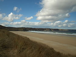
ISLE OF LEWIS
Police
Fire
Ambulance Scottish
EU Parliament Scotland
UK Parliament Na h-Eileanan an Iar
Scottish Parliament Western Isles
List of places: UK • Scotland •

North Tolsta (Scottish Gaelic: Tolastadh bho Thuath) is a village in the Scottish Outer Hebrides, on the east side of the Isle of Lewis. Tolsta is notable for its long sandy beach popular with surfers. The village of Bail' Ùr Tholastaidh (New Tolsta) is to the north and Glen Tholastaid to the south. At the end of Tolsta's long sandy beach there are 5 caves only visitable during low tide, these Caves are locally known as "The Caves of Life." There is a campsite nearby where the showers are a pound.


See also

References

External links

Coordinates: 58°20′48″N 6°12′38″W / 58.34667°N 6.21056°W / 58.34667; -6.21056


Wikimedia Foundation. 2010.

Игры ⚽ Поможем сделать НИР

Look at other dictionaries:

  • List of Sites of Special Scientific Interest in Western Isles North — The following is a list of Sites of Special Scientific Interest in the Western Isles North Area of Search; for Western Isles South see List of SSSIs in Western Isles South. For SSSIs elsewhere in Scotland, see List of SSSIs by Area of Search.*… …   Wikipedia

  • Lewis — Infobox UK place official name= Lewis gaelic name= Leòdhas map type= nomap static static image caption= Lewis shown within the Outer Hebrides | population= 18,489 latitude= 58.220163 longitude= 6.38301 country= Scotland os grid reference=… …   Wikipedia

  • Lewis (Ecosse) — Lewis (Écosse) Pour les articles homonymes, voir Lewis. 58° 11′ 30″ N 6° 36′ 08″ W …   Wikipédia en Français

  • Île de Lewis — Lewis (Écosse) Pour les articles homonymes, voir Lewis. 58° 11′ 30″ N 6° 36′ 08″ W …   Wikipédia en Français

  • List of state schools in Scotland/Council Areas S-W (excluding cities) — The following is a partial list of currently operating state schools in the unitary council areas of Scottish Borders, Shetland Islands, South Ayrshire, South Lanarkshire, Stirling, West Dunbartonshire, West Lothian and Western Isles in Scotland …   Wikipedia

  • Lewis (Écosse) — Pour les articles homonymes, voir Lewis. 58° 11′ 30″ N 6° 36′ 08″ W / …   Wikipédia en Français

  • List of community council areas in Scotland — This is a list of community council areas established in each of the council areas of Scotland.Aberdeen CityThere are 31 community council areas in the council area. Those marked with an asterisk have a community council. [… …   Wikipedia

  • Ness, Lewis — Coordinates: 58°28′N 6°15′W / 58.47°N 6.25°W / 58.47; 6.25 …   Wikipedia

  • Back, Outer Hebrides — Infobox UK place official name= Back gaelic name= Am Bac latitude= 58.28 longitude= 6.29 country= Scotland os grid reference= NB483408 post town= STORNOWAY postcode area= HS postcode district= HS2 dial code= 01851 constituency westminster= Na h… …   Wikipedia

  • Stornoway —    STORNOWAY, a burgh of barony, sea port, and parish, in the Island of Lewis, county of Ross and Cromarty, 120 miles (N. W. by W.) from Dingwall; containing, with the late quoad sacra parish of Knock or Uii, 6218 inhabitants, of whom 1354 are in …   A Topographical dictionary of Scotland

Share the article and excerpts

Direct link
Do a right-click on the link above
and select “Copy Link”