- Church of St Clement, Rodel
-
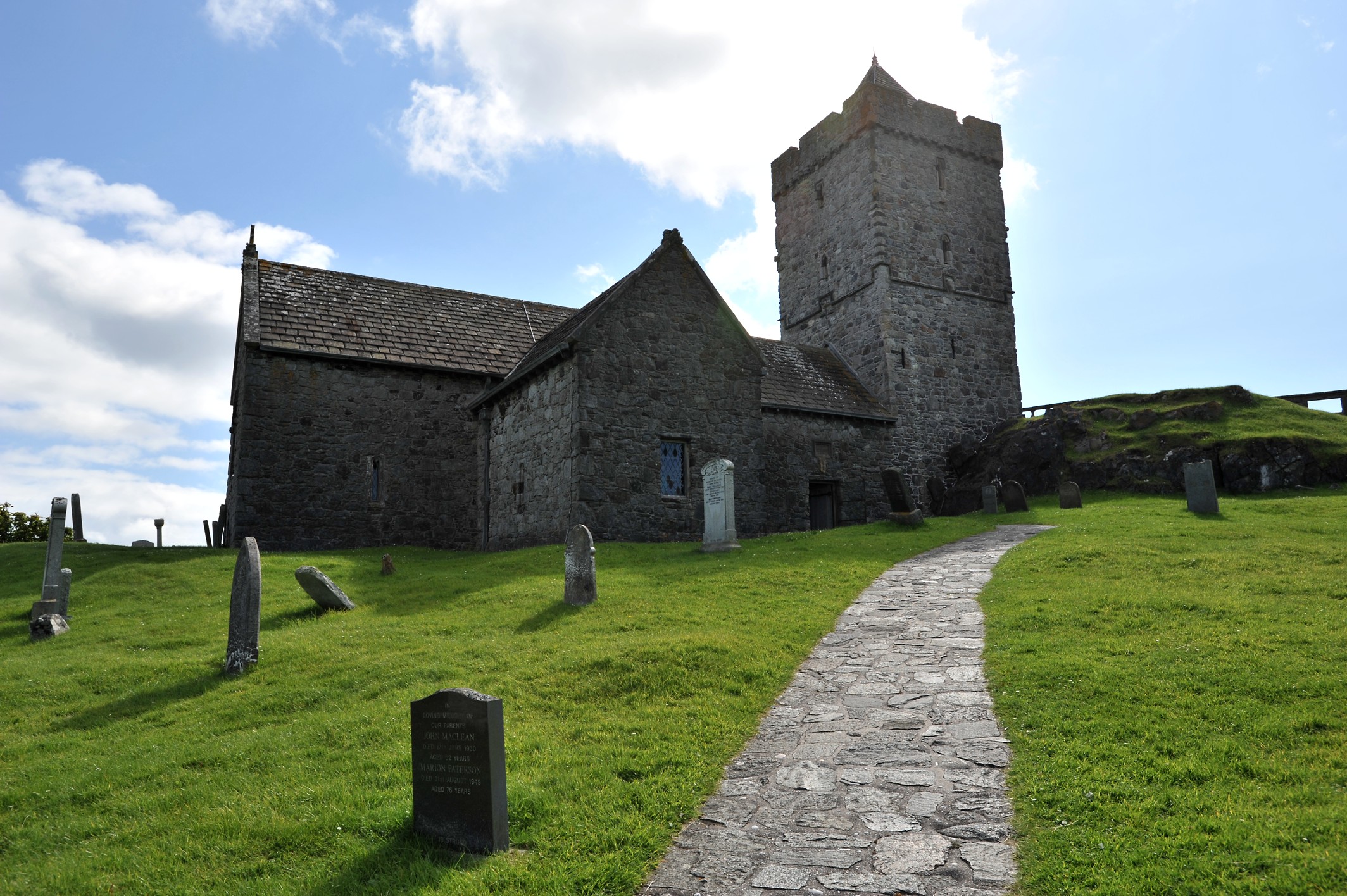
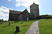 Saint Clement's church photographed from the pathway leading up to the main entrance
St Clement's Church (Scottish Gaelic: Tùr Chliamhainn, meaning Clement's Tower) is a fifteenth century church in Rodel, Harris, Scotland, built for the Chiefs of the MacLeods of Harris. It is dedicated to Pope Clement I. It is sometimes known as Eaglais Roghal or Rodal Church.
Contents
Architecture
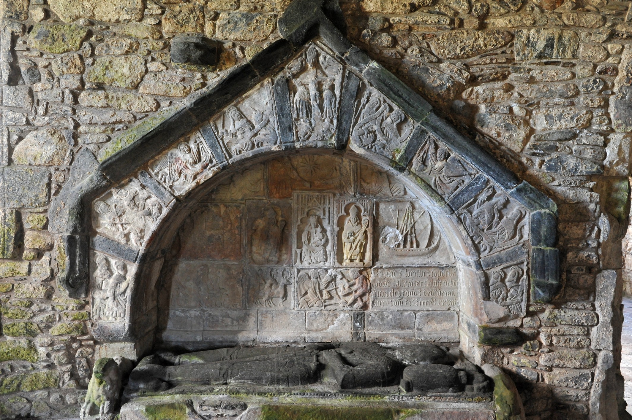
 Alasdair Crotach's wall tomb
The church was built using local Lewisian gneiss rock. Its ground plan is cruciform and there is a tower at the west end, accessible through a door at the west end of the nave and a set of stone staircases and wooden ladders. The choir and the sanctuary with the high alter, which used to be separated by the nave by a wooden screen, are located at the opposite east end of the church. In the transepts leading off from the nave on both sides, there are additional chapels, the entrance door points nord and leads to nave. The architectural style is essentially that of 1520 to 1550.
In 1528, Alasdair Crotach MacLeod, 8th Chief, prepared for himself a magnificent wall tomb on the south side of the choir - possibly the finest medieval wall tomb in Scotland, being crowned by an arch and ornated by carvings of biblical design. The 9th Chief, Alasadair or Alexander's son William, had his grave prepared in the south wall of the nave in 1539. In the south transept, there is a third grave probably belonging to John MacLeod of Minginish, the 10th Chief. There are five more grave slabs leaning against the wall of the north transept. The graveyard surrounding the church contains a number of MacLeod tombs.
History
According to Dean Donald Munro in his 1549 work about the Western Isles[1], the church was built for the Chiefs of the MacLeods of Harris, who lived in Dunvegan Castle in Skye, probably from about 1520, and is not considered the first church on the site although there is no clear evidence of an older celtic church. Munro described the church as a monastery, but as there is no evidence hinting to a monastic community, this expression is believed to refer to a minister, and with it to an important parish church. It was a Catholic church before falling into disuse shortly after its completion around 1560 as a consequence of the reformation, but the churchyard continued to be used as a MacLeod burial site. The church's decayed roof was renewed in 1784 by Captain Alexander MacLeod of Berneray, but burned down shortly after and had to be rebuilt once again in 1787. In the 19th century it was used as a cow byre before being restored by Catherine Herbert Countess of Dunmore in 1873, and in 1913, the tower was rebuilt after being damaged by a lightning stroke six years earlier. Today, the church is under the care of Historic Scotland. A notable 17th-century poetess Mary Macleod (Mairi Nighean Alasdair Ruaidh) is said to be buried here.
References
External links
- Panorama of St Clements Church (QuickTime required)
- St. Clement's Church / Tur Chliamainn, Rodel
- Feature page on undiscoveredscotland.co.uk
Coordinates: 57°44′23″N 6°57′39″W / 57.73967°N 6.960783°W
Settlements and Places of Interest in the Outer Hebrides (Na h-Eileanan Siar) on Lewis
and HarrisStornoway · Aird · Back · Balallan · Barvas · Bayble · Bragar · Breaclete (Great Bernera) · Brenish · Carloway · Garrabost · Ness · Portnaguran · Portvoller · Shawbost · Skigersta · Shulishader · Tong · Valtos/Uig
Tarbert · Leverburgh · Luskentyre · Northton · Rodel
on North Uist,
Benbecula
and South UistLochmaddy · Sollas
Lochboisdale · Balla (Eriskay) · Daliburgh · Geirinis · Howmore · Stoneybridge
Balivanich · Linaclateon Barra Places of Interest Amhuinnsuidhe Castle · An Lanntair · Arnol Blackhouse · Barra Airport · Callanish Stones · Dun Carloway · Garenin · Golden Road · Kisimul Castle · Lewis Loom Centre · Lews Castle · St. Clement's Church · St Moluag's ChurchClan MacLeod of Harris and Dunvegan and Clan MacLeod of Lewis Clan chiefs Leod · Tormod · Malcolm · Iain Ciar · William Cleireach · Iain Borb · William Dubh · Alasdair Crotach · William · Mary · Donald · Norman · William · John · Sir Rory Mor · John · Roderick · John · Roderick · Norman · John · Norman · Norman · John Norman · Norman · Norman Magnus · Sir Reginald · Dame Flora · John · Hugh MagnusMacLeod of LewisTorquil · Roderick · Torquil · Roderick · Torquil · Roderick · [Torquil] Roderick · [Torquil] DonaldCastles & buildings MacLeod of Harris and DunveganMacLeod of LewisClan heirlooms & relics MacLeod of Harris and DunveganClan battles MacLeod of Harris and DunveganBattle of Harlaw · Battle of Bloody Bay · Battle of Glendale · Battle of the Spoiling Dyke · Battle of Leckmelm · Battle of Coire Na CreicheMacLeod of LewisNames & families Related articles History of the Outer Hebrides · Highland Clearances · Olaf the Black · Páll Bálkason · Ljótólfr · Olvir Rosta · Þórkell ÞórmóðssonCategories:- 15th-century architecture
- Category A listed buildings in Scotland
- Clan Macleod
- Churches in the Outer Hebrides
- Historic Scotland properties
- Listed buildings in the Western Isles
- Listed churches in Scotland
Wikimedia Foundation. 2010.