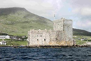
- Kisimul Castle
-
Kisimul Castle Part of Barra, Western Isles Castlebay, Scotland 
The walls and tower of the castle seen from the bay.Type Rectangular castle Coordinates 56°57′08″N 7°29′15″W / 56.95213°N 7.48744°WCoordinates: 56°57′08″N 7°29′15″W / 56.95213°N 7.48744°W Construction
materialsGranite Height 11 metres (36 ft) In use Until 1838 Current
conditionPartially restored Current
ownerClan MacNeil Open to
the publicYes Controlled by Historic Scotland Video from a boat trip around Kisimul Castle, 2011.
Kisimul (also Kiessimul or Chisimul) Castle is a small medieval castle located in the centre of Castlebay on Barra, an island of the Outer Hebrides, Scotland.
Kisimul (or Chisimul) Castle gets its name from the Gaelic words cìs (tax) and mul (mound) meaning "The place where taxes are paid".
Contents
History
The earliest documentary record of Kisimul Castle dates from the mid 16th century.[1]
Kisimul sits on a rocky islet in the bay just off the coast of Barra, and as it is completely surrounded by the sea; it can only be reached by boat making the fortification impregnable. Kisimul has its own fresh water wells. Legend has it that this has been the stronghold of the MacNeils since the 11th century.
Kisimul was abandoned in 1838 when the island was sold, and the castle's condition deteriorated. Some of its stone was used as ballast for fishing vessels, and some even ended up as paving in Glasgow. The remains of the castle, along with most of the island of Barra, were purchased by the chief of Clan MacNeill in 1937, who made efforts at restoration.
In 2001 the castle was leased by the chief of Clan MacNeil to Historic Scotland for 1000 years for the annual sum of £1 and a bottle of whisky.[2]
Archaeological survey
 Survey trenches in the courtyard of Kisimul Castle.
Archaeological investigations were carried out at Kisimul Castle by Headland Archaeology, on behalf of Historic Scotland.[3] This involved some excavation, building recording and archival research. It was hoped that the project would help clarify the date of the castle and its sequence of construction. Another aim was to establish whether or not the island had been occupied before construction of the castle.
 Gold object recovered during the excavations.
Excavation concentrated on areas of the courtyard, the basement of the tower and the bottom of a pit prison. At the east end of the courtyard there was a great deal of building rubble directly below the surface, some of which had mortar attached. This suggested that an earlier building had been demolished or collapsed, and the stone used to form a level courtyard. This happened before the building known as the kitchen was built. At the other end of the site a stone drain leading under the great hall was uncovered together with a paved stone surface. Above these was a layer containing large amounts of animal bone, shell and pottery. There were also floor surfaces within buildings that had been demolished.
During the excavation many finds were recovered. These included large quantities of animal bone and shell. Further study of these will allow us to discover more about the diet of those who lived in the castle. A large quantity of broken pottery was also found and appears to range in date from prehistoric times through the medieval period to the more recent past. A number of pieces of flint were recovered including a particularly fine flint blade. These tools together with some of the pottery show that people were using the island thousands of years before the present castle was built.
The most exciting find was recovered from one of the trenches dug within the tower. It is a fine, small gold object, shown here and in almost perfect condition. This is being looked at by specialists to discover its age and function.
See also
References
- ^ McDonald, R. Andrew (1997). The Kingdom of the Isles: Scotland's Western Seaboard c.1100-c.1336.. East Linton, East Lothian, Scotland: Tuckwell Press. pp. 236–237. ISBN 1-898-41085-2.
- ^ "Islands gifted to residents". BBC News. 2003-09-05. http://news.bbc.co.uk/1/hi/scotland/3083024.stm. Retrieved 2010-05-07.
- ^ [1]
External links
Images
Settlements and Places of Interest in the Outer Hebrides (Na h-Eileanan Siar) on Lewis
and HarrisStornoway · Aird · Back · Balallan · Barvas · Bayble · Bragar · Breaclete (Great Bernera) · Brenish · Carloway · Garrabost · Ness · Portnaguran · Portvoller · Shawbost · Skigersta · Shulishader · Tong · Valtos/Uig
Tarbert · Leverburgh · Luskentyre · Northton · Rodel
on North Uist,
Benbecula
and South UistLochmaddy · Sollas
Lochboisdale · Balla (Eriskay) · Daliburgh · Geirinis · Howmore · Stoneybridge
Balivanich · Linaclateon Barra Places of Interest Amhuinnsuidhe Castle · An Lanntair · Arnol Blackhouse · Barra Airport · Callanish Stones · Dun Carloway · Garenin · Golden Road · Kisimul Castle · Lewis Loom Centre · Lews Castle · St. Clement's Church · St Moluag's ChurchBarra Settlements Mountains and hills History, culture and economy Castlebay Community School · Clan MacNeil · Compton Mackenzie · Eriskay Pony · Isle of Barra distillery · Kisimul Castle · Whisky Galore!Transport Surrounding islands: Sound of Barra Surrounding islands: Barra Isles Categories:- Barra
- Castles in the Western Isles
- Category A listed buildings in Scotland
- Listed buildings in the Western Isles
- Listed castles in Scotland
- Clan MacNeil
- Historic Scotland properties
Wikimedia Foundation. 2010.


