- Dun Carloway
-
Coordinates: 58°16′10.35″N 6°47′38.47″W / 58.2695417°N 6.7940194°W
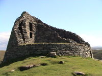
 Photo of the broch
 Photo of the broch
Dun Carloway (in Scottish Gaelic Dùn Chàrlabhaigh) is a broch situated in the district of Carloway, on the west coast of the Isle of Lewis, Scotland. It is a remarkably well preserved broch - on the east side parts of the old wall still reaches to 9 metres tall. In places there are also more modern repairs to the east wall. Dun Carloway was probably built some time in the 1st century BC, and radiocarbon dating evidence from remains found in the broch show that it was last occupied around 1300 AD. At the base the broch is around 14 to 15 metres in diameter and the walls around 3 metres thick. It has a circular plan and hollow walls and was built without mortar. It probably had wooden floors, internal partitions and a thatched roof, necessary to make it habitable, but the only remaining evidence of this are post-holes. Together with the roof, the narrow passageway presumably secured by a wooden door, were the most vulnerable points of the building, especially to fire.
External links
- Photos of Dun Carloway broch on the Ancient Scotland site
- Dun Carloway broch on the Megalithic Portal
- Panoramas of Carloway Broch (QuickTime required)
Settlements and Places of Interest in the Outer Hebrides (Na h-Eileanan Siar) on Lewis
and HarrisStornoway · Aird · Back · Balallan · Barvas · Bayble · Bragar · Breaclete (Great Bernera) · Brenish · Carloway · Garrabost · Ness · Portnaguran · Portvoller · Shawbost · Skigersta · Shulishader · Tong · Valtos/Uig
Tarbert · Leverburgh · Luskentyre · Northton · Rodel
on North Uist,
Benbecula
and South UistLochmaddy · Sollas
Lochboisdale · Balla (Eriskay) · Daliburgh · Geirinis · Howmore · Stoneybridge
Balivanich · Linaclateon Barra Places of Interest Amhuinnsuidhe Castle · An Lanntair · Arnol Blackhouse · Barra Airport · Callanish Stones · Dun Carloway · Garenin · Golden Road · Kisimul Castle · Lewis Loom Centre · Lews Castle · St. Clement's Church · St Moluag's ChurchPrehistoric Western Isles Callanish Sites Other Neolithic Sites Bronze and Iron Age Sites Brochs Shetland Orkney Hebrides Dun Carloway · Dun BeagHighlands Southern Scotland Categories:- Brochs
- Lewis
- Scheduled Ancient Monuments in Scotland
- Historic Scotland properties
- Archaeological sites in the Western Isles
- Scottish building and structure stubs
- Western Isles geography stubs
Wikimedia Foundation. 2010.
