- Österåker Municipality
-
Österåkers kommun — Municipality — 
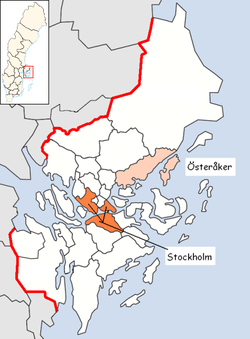
Coat of armsCountry Sweden County Stockholm County Seat Åkersberga Area[1] – Total 558.23 km2 (215.5 sq mi) – Land 310.75 km2 (120 sq mi) – Water 247.48 km2 (95.6 sq mi) Area as of January 1, 2010. Population (June 30, 2010)[2] – Total 39,335 – Density 70.5/km2 (182.5/sq mi) Time zone CET (UTC+1) – Summer (DST) CEST (UTC+2) Postal code ISO 3166 code SE Province Uppland Municipal code 0117 Website www.osteraker.se Density is calculated using land area only. Österåker Municipality (Swedish: Österåkers kommun, IPA: [ˈœstərˈoːkərs kɔˈmʉːn]) is a municipality in Stockholm County in east central Sweden. Its seat is located in the town of Åkersberga, with a population of 26,727 (2005).
From 1974 to 1982 Österåker was part of Vaxholm Municipality.
Its location by the Stockholm archipelago, in the Roslagen area, attracts both people who settles here, often commuting to Stockholm, and visiting tourists. Österåker boasts several golf courses, many possibilities for canoeing, horse riding, fishing and other nature activities.
Of the 800 islands and islets, the largest one is Ljusterö, a community of its own covering the eastern side of the mainland, and accessible by car. Easy access is granted by regular ferries, including one old steam ship from 1898. Other major islands are Finnhamn, Husarö and Ingmarsö.
Österåker also has a historical significance, with at least three notable castles from the 17th and 18th centuries, with histories tracing even further back.
Like many other municipalities making up Metropolitan Stockholm, Österåker has a significant outward-commuting mainly to Stockholm, with some 13,000 commuters.
Contents
Localities
- Rydbo
- Skärgårdsstad
- Svinninge
- Åkersberga (seat)
- Österskär
Public transportation
Österåker is served by the Stockholm public transport system through SL. There are six stops on the narrow gauge Roslagsbanan suburban railway and buses to Stockholm and Norrtälje as well as an extensive internal bus network.
External links
- Österåker Municipality - Official site
References
- ^ "Statistiska centralbyrån den 1 januari 2010" (in Swedish) (Microsoft Excel). Statistics Sweden. http://www.scb.se/Statistik/MI/MI0802/2010A01/mi0802tab3_2010.xls. Retrieved 2010-08-21.
- ^ "SCB, Befolkningsstatistik 30 juni 2010" (in Swedish). Statistics Sweden. http://www.scb.se/Pages/TableAndChart____244147.aspx. Retrieved 2010-08-19.
Municipalities and seats of Stockholm County Municipalities 
Municipal seats Localities in Österåker Municipality, Stockholm County, Sweden Localities: Åkersberga (seat) · Bammarboda · Hagbyhöjden · Norrö · Rydbo · Skärgårdsstad · Solberga · Stava · Svinninge · TäljöCategories:- Municipalities of Sweden
- Municipalities of Stockholm County
- Metropolitan Stockholm
Wikimedia Foundation. 2010.

