- Middlesex, North Carolina
-
Middlesex, North Carolina — Town — Location of Middlesex, North Carolina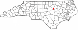
Coordinates: 35°47′23″N 78°12′12″W / 35.78972°N 78.20333°WCoordinates: 35°47′23″N 78°12′12″W / 35.78972°N 78.20333°W Country United States State North Carolina County Nash Area – Total 1.0 sq mi (2.5 km2) – Land 1.0 sq mi (2.5 km2) – Water 0.0 sq mi (0.0 km2) Elevation 262 ft (80 m) Population (2000) – Total 838 – Density 858.6/sq mi (331.5/km2) Time zone Eastern (EST) (UTC-5) – Summer (DST) EDT (UTC-4) ZIP code 27557 Area code(s) 252 FIPS code 37-42700[1] GNIS feature ID 1021436[2] Middlesex is a town in Nash County, North Carolina, United States. It is part of the Rocky Mount, North Carolina Metropolitan Statistical Area. Middlesex is about 25 miles east of Raleigh, North Carolina. The population was 838 at the 2000 census.
Contents
Geography
Middlesex is located at 35°47′23″N 78°12′12″W / 35.78972°N 78.20333°W (35.789769, -78.203428)[3].
According to the United States Census Bureau, the town has a total area of 1.0 square mile (2.6 km2), all of it land.
Demographics
As of the census[1] of 2000, there were 838 people, 381 households, and 235 families residing in the town. The population density was 858.6 people per square mile (330.2/km²). There were 426 housing units at an average density of 436.5 per square mile (167.8/km²). The racial makeup of the town was 63.25% White, 32.70% African American, 0.24% Native American, 3.58% from other races, and 0.24% from two or more races. Hispanic or Latino of any race were 7.52% of the population.
There were 381 households out of which 27.0% had children under the age of 18 living with them, 41.2% were married couples living together, 16.8% had a female householder with no husband present, and 38.1% were non-families. 34.6% of all households were made up of individuals and 18.1% had someone living alone who was 65 years of age or older. The average household size was 2.20 and the average family size was 2.81.
In the town the population was spread out with 23.3% under the age of 18, 10.3% from 18 to 24, 25.1% from 25 to 44, 23.2% from 45 to 64, and 18.3% who were 65 years of age or older. The median age was 38 years. For every 100 females there were 87.9 males. For every 100 females age 18 and over, there were 82.2 males.
The median income for a household in the town was $21,458, and the median income for a family was $26,488. Males had a median income of $23,182 versus $19,886 for females. The per capita income for the town was $13,717. About 21.4% of families and 21.8% of the population were below the poverty line, including 30.3% of those under age 18 and 23.5% of those age 65 or over.
Buildings and constructions
- Capstar Radio Tower (600 metre high guyed TV mast)
References
- ^ a b "American FactFinder". United States Census Bureau. http://factfinder.census.gov. Retrieved 2008-01-31.
- ^ "US Board on Geographic Names". United States Geological Survey. 2007-10-25. http://geonames.usgs.gov. Retrieved 2008-01-31.
- ^ "US Gazetteer files: 2010, 2000, and 1990". United States Census Bureau. 2011-02-12. http://www.census.gov/geo/www/gazetteer/gazette.html. Retrieved 2011-04-23.
Municipalities and communities of Nash County, North Carolina City 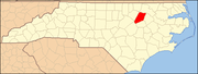
Towns Bailey | Castalia | Dortches | Middlesex | Momeyer | Nashville | Red Oak | Sharpsburg‡ | Spring Hope | Whitakers‡
Footnotes ‡This populated place also has portions in an adjacent county or counties
Categories:- Populated places in Nash County, North Carolina
- Towns in North Carolina
- Rocky Mount metropolitan area


Wikimedia Foundation. 2010.