- Drumnadrochit
-
Coordinates: 57°20′14″N 4°28′48″W / 57.3373°N 4.4800°W
Drumnadrochit Scottish Gaelic: Druim na Droichaid
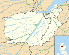
 Drumnadrochit shown within the Inverness area
Population 813 [1] (2001 census)
est. 1,020[2] (2006)OS grid reference NH507301 Council area Highland Lieutenancy area Inverness Country Scotland Sovereign state United Kingdom Post town INVERNESS Postcode district IV63 Dialling code 01456 Police Northern Fire Highlands and Islands Ambulance Scottish EU Parliament Scotland UK Parliament Inverness, Nairn, Badenoch and Strathspey Scottish Parliament Highlands and Islands Inverness East, Nairn and Lochaber List of places: UK • Scotland • Drumnadrochit (Scottish Gaelic, Druim na Droichaid) is a village in the Highland local government council area of Scotland, lying on the west shore of Loch Ness, at the foot of Glen Urquhart.
Contents
History
The settlement grew up around a bridge over the River Enrick and the name Drumnadrochit is thought to be derived from the Scottish Gaelic and mean the 'Ridge of the Bridge'. The village lies on the A82 road, near a junction with the A831, adjoining the villages of Milton[disambiguation needed
 ] to the West and Lewiston to the South. The local hill-come-tourist atraction is called Craig Monie. [3]
Historically it was within the local government county of Inverness (until 1975) and the Inverness district of the Highland local government region (1975 to 1996).
In 2006 the village hall celebrated its centenary.[4]
Drumnadrochit is served by the local Glen Urquhart High School.[5]
There is a pharmacy, the Great Glen Pharmacy, which opened recently.
The village is home to shinty team Glenurquhart Shinty Club.
Transport
There is an occasional weekday bus service to Inverness.
Agriculture and tourism
The village is popular with tourists and there are three hotels. Attractions include several Loch Ness Monster exhibitions, and the nearby Urquhart Castle which is one of the most visited sites owned by Historic Scotland. A winter event, Drums and Rockets, has also recently commenced.[6] Agriculture and forestry are also major local employers.
See also
Gallery
-
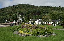
Drumnadrochit in 1998.
-
Drumnadrochit in 1998. The school is top right.[7]
-
The supermarket in Drumnadrochit during 1997.
References
- ^ "Comparative Population Profile: Drumnadrochit Locality". Scotland's Census Results Online. 2001-04-29. http://www.scrol.gov.uk/scrol/browser/profile.jsp?profile=Population&mainArea=drumnadrochit&mainLevel=Locality. Retrieved 2008-09-02.
- ^ http://www.gro-scotland.gov.uk/statistics/publications-and-data
- ^ http://www.craigmoniecentre.co.uk/index.asp?pageid=4530
- ^ Glen Urquhart Public Hall. "Village Hall". http://www.glenurquhart.info.
- ^ Redmond J. "Glen Urquhart High School". http://www.glenurquharthigh.highland.sch.uk.
- ^ Loch Ness Hogmanay Festival. "Drums and Rockets". http://www.drumsandrockets.co.uk/.
- ^ Redmond J. "Glen Urquhart High School". http://www.glenurquharthigh.highland.sch.uk.
Categories:- Populated places in Inverness committee area
- Highland geography stubs
-
Wikimedia Foundation. 2010.


