- Montour Falls, New York
-
Montour Falls, New York — Village — Downtown Montour Falls Location within the state of New York
 Montour Falls, New York
Coordinates: 42°20′57″N 76°50′47″W / 42.34917°N 76.84639°WCoordinates: 42°20′57″N 76°50′47″W / 42.34917°N 76.84639°W Country United States State New York County Schuyler Area – Total 3.0 sq mi (7.8 km2) – Land 3.0 sq mi (7.8 km2) – Water 0.0 sq mi (0.1 km2) Elevation 449 ft (137 m) Population (2000) – Total 1,797 – Density 597.7/sq mi (230.8/km2) Time zone Eastern (EST) (UTC-5) – Summer (DST) EDT (UTC-4) ZIP code 14865 Area code(s) 607 FIPS code 36-48197 GNIS feature ID 0974235 Montour Falls is a village in Schuyler County, New York, United States. The population was 1,797 at the 2000 census. A waterfall in the village gives the village its name. The name "Montour" is derived from Queen Catharine Montour of the Senecas www.schuylerhistory.org/Queen_Catharine_Montour.pdf.
The Village of Montour Falls is mostly within the Town of Montour, but a small part in within the Town of Dix. The village is north of Elmira, New York.
The New York Academy of Fire Science is located in the village.
Contents
History
The village was previously known as Queanettquaga, Catherine's Town, and finally Havana by 1788. The original native village was destroyed by the Sullivan Expedition of 1779. The current village was settled around 1790.
It was the first county seat of Schuyler County, but in 1861 the county seat was moved to Watkins Glen. The current name of Montour Falls was adopted in 1890. The village was located on the former Chemung Canal and was incorporated in 1836.
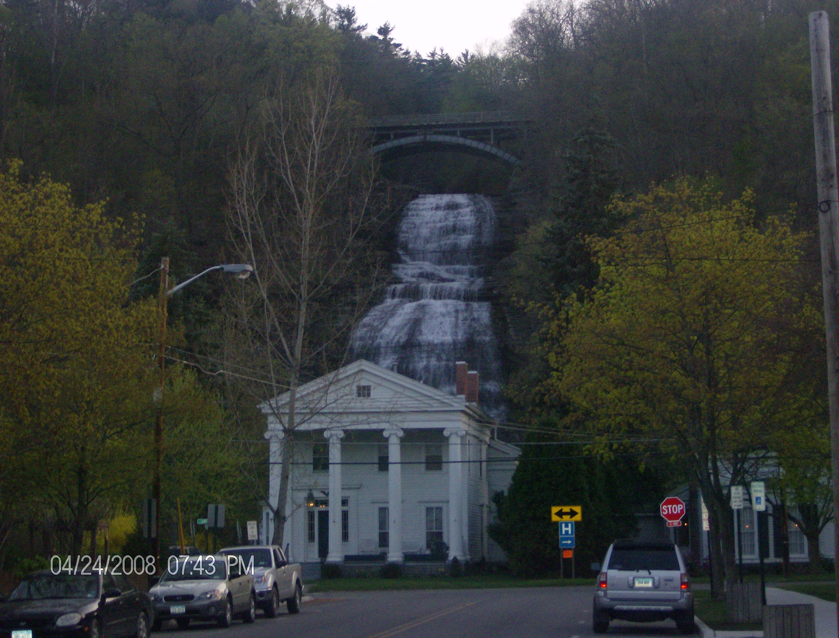
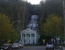 Shequaga Falls overlooks the town of Montour Falls
The main attraction is a 150' waterfall located on the west side of the village. At the base of the falls the sign spells it "She-qua-ga". On the bridge above the waterfall it's spelled "Che-qua-ga". The historian was recently asked about the difference in spelling. She claims the original spelling was "Che-qua-ga" and that apparently someone along the way began spelling it incorrectly and it stuck. In addition to the two spellings you will also see it written with the 'S' or 'C' but without the hyphens. Some may refer to the falls as simply "Montour Falls".
The former Chemung Canal passed through the village.
Geography
Montour Falls is located at 42°20′57″N 76°50′47″W / 42.34917°N 76.84639°W (42.349209, -76.846450)[1].
According to the United States Census Bureau, the village has a total area of 3.0 square miles (7.8 km2), of which, 3.0 square miles (7.8 km2) of it is land and 0.04 square miles (0.10 km2) of it (0.66%) is water.
New York State Route 14 intersects New York State Route 224 in Montour Falls.
Catharine Creek flows northward through the Catharine Creek Valley toward Seneca Lake.
Demographics
As of the census[2] of 2000, there were 1,797 people, 701 households, and 419 families residing in the village. The population density was 597.7 people per square mile (230.5/km²). There were 755 housing units at an average density of 251.1 per square mile (96.8/km²). The racial makeup of the village was 97.61% White, 1.00% African American, 0.33% Native American, 0.22% Asian, 0.17% Pacific Islander, and 0.67% from two or more races. Hispanic or Latino of any race were 0.39% of the population.
There were 701 households out of which 26.1% had children under the age of 18 living with them, 42.2% were married couples living together, 12.7% had a female householder with no husband present, and 40.1% were non-families. 33.0% of all households were made up of individuals and 20.7% had someone living alone who was 65 years of age or older. The average household size was 2.22 and the average family size was 2.79.
In the village the population was spread out with 19.1% under the age of 18, 7.6% from 18 to 24, 23.9% from 25 to 44, 21.6% from 45 to 64, and 27.7% who were 65 years of age or older. The median age was 44 years. For every 100 females there were 77.9 males. For every 100 females age 18 and over, there were 70.1 males.
The median income for a household in the village was $29,018, and the median income for a family was $36,307. Males had a median income of $31,064 versus $21,813 for females. The per capita income for the village was $15,671. About 11.5% of families and 15.3% of the population were below the poverty line, including 24.0% of those under age 18 and 7.4% of those age 65 or over.
References
- ^ "US Gazetteer files: 2010, 2000, and 1990". United States Census Bureau. 2011-02-12. http://www.census.gov/geo/www/gazetteer/gazette.html. Retrieved 2011-04-23.
- ^ "American FactFinder". United States Census Bureau. http://factfinder.census.gov. Retrieved 2008-01-31.
External links
Municipalities and communities of Schuyler County, New York Towns 
Villages Burdett | Montour Falls | Odessa | Watkins Glen
Categories:- Villages in New York
- Populated places in Schuyler County, New York


Wikimedia Foundation. 2010.