- Corfu, New York
-
For other uses, see Corfu (disambiguation).
Corfu, New York — Village — Location within the state of New York
 Corfu, New York
Coordinates: 42°57′31″N 78°24′14″W / 42.95861°N 78.40389°WCoordinates: 42°57′31″N 78°24′14″W / 42.95861°N 78.40389°W Country United States State New York County Genesee Area - Total 1.0 sq mi (2.6 km2) - Land 1.0 sq mi (2.6 km2) - Water 0.0 sq mi (0.0 km2) Elevation 863 ft (263 m) Population (2000) - Total 795 - Density 804.2/sq mi (310.5/km2) Time zone Eastern (EST) (UTC-5) - Summer (DST) EDT (UTC-4) ZIP code 14036 Area code(s) 585 FIPS code 36-18201 GNIS feature ID 0947446 Corfu is a village in Genesee County, New York, United States. The population was 795 at the 2000 census. It is named after the Island of Corfu.
The Village of Corfu lies at the south town line of the Town of Pembroke so that a small part of the village is in the Town of Darien.
Contents
History
The early community was known as Longs Corners. The name "Corfu" was adopted when a post office was established. The Village of Corfu was incorporated in 1868, setting the community off from the Towns of Pembroke and Darien.
Geography
Corfu is located at 42°57′31″N 78°24′14″W / 42.95861°N 78.40389°W (42.958662, -78.403938)[1].
According to the United States Census Bureau, the village has a total area of 1.0 square mile (2.6 km2), all of it land.
Murder Creek, a tributary of the Tonawanda Creek, flows through the village.
The village is at the intersection of Routes NY-33 and NY-77 and is north of the Darien Lake Theme Park Resort and Darien Lakes State Park. NY-77 connects the village to the New York State Thruway, a few miles to the north.
Demographics
As of the census[2] of 2000, there were 795 people, 309 households, and 211 families residing in the village. The population density was 804.2 people per square mile (310.1/km²). There were 336 housing units at an average density of 339.9 per square mile (131.0/km²). The racial makeup of the village was 96.98% White, 0.88% African American, 0.63% Native American, 0.38% from other races, and 1.13% from two or more races. Hispanic or Latino of any race were 1.38% of the population.
There were 309 households out of which 36.9% had children under the age of 18 living with them, 55.3% were married couples living together, 9.4% had a female householder with no husband present, and 31.7% were non-families. 24.3% of all households were made up of individuals and 9.7% had someone living alone who was 65 years of age or older. The average household size was 2.57 and the average family size was 3.11.
In the village the population was spread out with 28.3% under the age of 18, 7.8% from 18 to 24, 32.5% from 25 to 44, 19.7% from 45 to 64, and 11.7% who were 65 years of age or older. The median age was 35 years. For every 100 females there were 89.7 males. For every 100 females age 18 and over, there were 88.1 males.
The median income for a household in the village was $37,386, and the median income for a family was $46,667. Males had a median income of $32,917 versus $23,571 for females. The per capita income for the village was $15,909. 1.4% of families and 4.2% of the population were below the poverty line, including 2.6% of those under age 18 and 7.5% of those age 65 or over.
References
- ^ "US Gazetteer files: 2010, 2000, and 1990". United States Census Bureau. 2011-02-12. http://www.census.gov/geo/www/gazetteer/gazette.html. Retrieved 2011-04-23.
- ^ "American FactFinder". United States Census Bureau. http://factfinder.census.gov. Retrieved 2008-01-31.
External links
Municipalities and communities of Genesee County, New York County seat: Batavia City 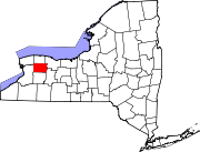
Towns Villages Hamlets Indian
reservationFootnotes ‡This populated place also has portions in an adjacent county or counties
Categories:- Villages in New York
- Populated places in Genesee County, New York


Wikimedia Foundation. 2010.