- New York State Route 239
-
NYS Route 239
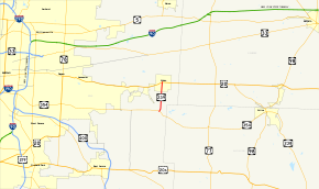
Map of the Buffalo area with NY 239 highlighted in redRoute information Maintained by NYSDOT Length: 2.92 mi[3] (4.70 km) Existed: 1930[1] – September 25, 1980[2] Major junctions South end:  NY 354 in Marilla
North end:  US 20 in Alden
Location Counties: Erie Highway system Numbered highways in New York
Interstate • U.S. • N.Y. (former) • Reference • County←  NY 238
NY 240  →
→New York State Route 239 (NY 239) was a state highway in eastern Erie County, New York, United States. The southern terminus of the route was at an intersection with NY 354 in Marilla. Its northern terminus was at a junction with U.S. Route 20 (US 20) in the village of Alden. NY 239 was about 3 miles (5 km) in length and named Exchange Street.
When NY 239 was assigned as part of the 1930 renumbering of state highways in New York, it extended eastward to the Wyoming County village of Attica. NY 239 was truncated to Marilla in the late 1940s, then removed from the state highway system completely in September 1980 as a result of a highway maintenance swap between the state of New York and Erie County earlier that year. The roadway is now County Route 578 (CR 578).
Contents
Route description
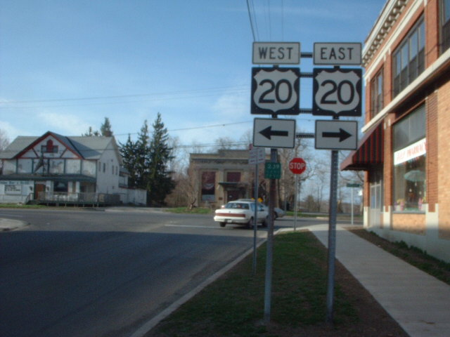
 Northern terminus of NY 239 as it appeared in 2003. A reference marker for NY 239 is still posted below the sign assembly.
NY 239 began at an intersection with NY 354 just west of the Erie–Wyoming county line in the town of Marilla. The route then traveled to the northeast, climbing in elevation as it proceeded onward. It then made a turn to the north, descending in elevation. Running at about a height of 900 feet (270 m) above sea level, NY 239 crossed into the town of Alden and continued toward downtown.[4] NY 239 continued northward, passing nearby Henskee Road, a connector between NY 239 and County Line Road, which ran parallel to NY 239 along the Erie–Genesee county line. The route dipped further in elevation, entering the village of Alden. Inside the village, it passed the Buffalo Water Filtration Plant to the west and crossed the Conrail-owned Buffalo Line. NY 239 passed through a primarily residential area of the village just before terminating at US 20 in the village center.[5]
History
NY 239 as part of the 1930 renumbering of state highways in New York to an alignment extending from NY 35 in the village of Alden to NY 98 in the village of Attica by way of the hamlet of Cowlesville. The east–west road linking NY 239 near Cowlesville to Two Rod Road (then NY 358) north of Marilla was initially unnumbered.[1] It became part of a realigned NY 354 ca. 1935.[6][7] NY 354 was extended eastward in the late 1940s over NY 239's alignment to a new terminus in Attica. As a result, NY 239 was truncated to its junction with NY 354 in the town of Marilla.[8][9]
On April 1, 1980, ownership and maintenance of NY 239 was transferred from the state of New York to Erie County as part of a larger highway maintenance swap between the two levels of government.[10] The NY 239 designation was removed on September 25 of that year.[2] The highway is now designated by Erie County as CR 578.[11]
Major intersections
The entire route was in Erie County.
Location Mile[3] Destinations Notes Marilla 0.00 NY 354Village of Alden 2.92 US 201.000 mi = 1.609 km; 1.000 km = 0.621 mi References
- ^ a b Standard Oil Company of New York (1930). Road Map of New York (Map). Cartography by General Drafting.
- ^ a b New York State Department of Transportation (January 2009) (PDF). Official Description of Highway Touring Routes, Bicycling Touring Routes, Scenic Byways, & Commemorative/Memorial Designations in New York State. https://www.nysdot.gov/divisions/operating/oom/transportation-systems/repository/2009%20tour-bk.pdf. Retrieved May 22, 2009.
- ^ a b "Erie County Highway Pavement Condition Assessment Report" (PDF). Erie County Department of Public Works. October 2001. p. 39. http://www.erie.gov/assessment.pdf. Retrieved May 22, 2009.
- ^ United States Geological Survey (1949). Cowlesville Quadrangle – New York (Map). 1:24,000. 7.5 Minute Series (Topographic). http://www.nysgis.state.ny.us/gisdata/quads/drg24/usgspreview/index.cfm?code=o42078g4. Retrieved May 22, 2009.
- ^ United States Geological Survey (1984). Corfu – New York (Map). 1:25,000. 7.5 x 15 Minute Series (Topographic). http://www.nysgis.state.ny.us/gisdata/quads/drg24/usgspreview/index.cfm?code=k42078h3. Retrieved May 22, 2009.
- ^ Texas Oil Company (1934). Road Map of New York (Map). Cartography by Rand McNally and Company.
- ^ Sun Oil Company (1935). Road Map & Historical Guide – New York (Map). Cartography by Rand McNally and Company.
- ^ State of New York Department of Public Works. Official Highway Map of New York State (Map). Cartography by General Drafting (1947–48 ed.).
- ^ Esso (1949). New York (Map). Cartography by General Drafting (1950 ed.).
- ^ New York State Legislature. "Highway Law, Article 12, Section 341". http://public.leginfo.state.ny.us/menugetf.cgi?COMMONQUERY=LAWS. Retrieved May 22, 2009.
- ^ New York State Department of Transportation (1998). Cowlesville Digital Raster Quadrangle (Map). 1:24,000. http://www.nysgis.state.ny.us/gisdata/quads/drg24/dotpreview/index.cfm?code=r11. Retrieved May 22, 2009.
External links
Categories:- Former state highways in New York
- Transportation in Erie County, New York


Wikimedia Foundation. 2010.