- Mandarmani
-
Mandarmani — village — Mandarmani Sea Beach Coordinates 21°41′N 87°33′E / 21.68°N 87.55°ECoordinates: 21°41′N 87°33′E / 21.68°N 87.55°E Country India State West Bengal District(s) Purba Medinipur Population
• Density
12,307 (2011[update])
• 406 /km2 (1,052 /sq mi)
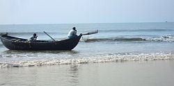
Sex ratio 976 ♂/♀ Time zone IST (UTC+05:30) Website [http://Mandarmani website Mandarmani website] Mandarmani is a large and fast developing seaside resort village in the state of West Bengal, India. It lies in East Midnapore district and at the northern end of the Bay of Bengal. Mandarmani is connected to Kolkata/Howrah by a highway. It is argued to be the longest driveable beach in India. Geomorphologically, this area has relatively low waves than nearer tourist beach of Digha. However still this beach is deposition with formation of neo dunes in several areas specially around Dadanpatrabar.
From Contai this can be travelled through a place called Chaulkhola.
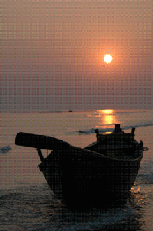
Mandarmani boasts of a 13 km long motorable beach, probably the longest motorable beach road in India. This is a drive-in beach. The beach is characterized by hard sand which makes it very appropriate for driving. People have been known to travel to Mandarmani from Digha, using the beachway. The main attraction of Mandarmani lies in the fact that it is still not as popularized and publicized as the other prominent beaches along the Bay of Bengal, and therefore is very serene and desolate. Even on common holidays, it seems as if you are the only one enjoying the view. It is an ideal place to relax, far away from the hustle and bustle of Kolkata. The sunrise and sunset are a treat to the eyes. The peaceful atmosphere brings a sense of relief to one's soul. Although this phenomenon was not that evident around 2 years ago, the sea has started encroaching on Mandarmani like it has done all along the Bay of Bengal coastline.In the evening, during the high tide, water moves forward more than 50 meters inland, effectively banging the concrete bases of the resorts that populate the otherwise empty shoreline. While the shores had to be reinforced with concrete along the Digha coastline due to the damage sea water was doing to the town, Mandarmani had to suddenly start tackling this issue due to water encroachment. As the place is still underdeveloped and doesn't have a dedicated electricity connection, the resorts usually work on generators making the place a bit more expensive than other favorite haunts near Kolkata. The best way of reaching Mandarmani is to take any bus from the Esplanade or the Howrah bus depot, that is going towards Digha. On the way, after crossing Contai, there is a stoppage named Chaulkhola. Once there, the tourist must avail a motored van to take him to Mandarmani. The place is also approchable by train through Contai, but the journey must be breaked as the only way to enter Mandarmani is through Chaulkhola.
See also
- Digha
- Shankarpur
External Links
Purba Medinipur district topics General Subdivisions Territories Locations
other than cities and townsMunicipalities Community development blocks Tamluk subdivision Nandakumar • Moyna • Tamluk • Sahid Matangini • Panskura I • Panskura II • Chandipur Haldia subdivision Mahisadal • Nandigram I • Nandigram II • Sutahata • Haldia Egra subdivision Bhagabanpur I • Bhagabanpur II • Egra I • Egra II • Patashpur I • Patashpur II Contai subdivision Contai I • Contai II • Contai III • Khejuri I • Khejuri II • Ramnagar I • Ramnagar IIRivers Transport Lok Sabha constituencies Vidhan Sabha constituencies Tamluk • Panskura Purba • Panskura Paschim • Moyna • Nandakumar • Mahisadal • Haldia • Nandigram • Chandipur • Patashpur • Kanthi Uttar • Bhagabanpur • Khejuri • Kanthi Dakshin • Ramnagar • EgraFormer Vidhan Sabha constituencies See also Cities and towns in Purba Medinipur district • People from Purba Medinipur district • Villages in Purba Medinipur district • Damodar ValleyOther districts in West Bengal Bankura • Bardhaman • Birbhum • Cooch Behar • Dakshin Dinajpur • Darjeeling • Hooghly · Howrah • Jalpaiguri • Kolkata • Malda • Murshidabad · Nadia • North 24 Parganas • Paschim Medinipur • Purulia • South 24 Parganas • Uttar DinajpurSurrounding areas outside West Bengal Categories:- Beaches of West Bengal
- Villages in Purba Medinipur district
- West Bengal geography stubs
Wikimedia Foundation. 2010.


