- Dexter, New Mexico
-
Dexter, New Mexico — Town — Location of Dexter, New Mexico
Coordinates: 33°11′46″N 104°22′13″W / 33.19611°N 104.37028°WCoordinates: 33°11′46″N 104°22′13″W / 33.19611°N 104.37028°W Country United States State New Mexico County Chaves Area – Total 0.8 sq mi (2.1 km2) – Land 0.7 sq mi (1.9 km2) – Water 0.1 sq mi (0.2 km2) Elevation 3,465 ft (1,056 m) Population (2000) – Total 1,235 – Density 1,681.2/sq mi (649.1/km2) Time zone Mountain (MST) (UTC-7) – Summer (DST) MDT (UTC-6) ZIP code 88230 Area code(s) 575 FIPS code 35-20620 GNIS feature ID 0888359 Dexter is a town in Chaves County, New Mexico, United States. The population was 1,235 at the 2000 census. This town is also known, as Midway.[1]
Contents
Geography
Dexter is located at 33°11′46″N 104°22′13″W / 33.19611°N 104.37028°W (33.196062, -104.370222)[2].
According to the United States Census Bureau, the town has a total area of 0.8 square miles (2.1 km2), of which, 0.7 square miles (1.8 km2) of it is land and 0.1 square miles (0.26 km2) of it (7.59%) is water.
Demographics
As of the census[3] of 2000, there were 1,235 people, 390 households, and 333 families residing in the town. The population density was 1,681.2 people per square mile (653.2/km²). There were 434 housing units at an average density of 590.8 per square mile (229.5/km²). The racial makeup of the town was 60.00% White, 0.24% African American, 0.73% Native American, 35.47% from other races, and 3.56% from two or more races. Hispanic or Latino of any race were 71.17% of the population.
There were 390 households out of which 47.9% had children under the age of 18 living with them, 62.3% were married couples living together, 17.7% had a female householder with no husband present, and 14.6% were non-families. 11.5% of all households were made up of individuals and 4.9% had someone living alone who was 65 years of age or older. The average household size was 3.17 and the average family size was 3.39.
In the town the population was spread out with 35.3% under the age of 18, 9.9% from 18 to 24, 27.4% from 25 to 44, 17.1% from 45 to 64, and 10.3% who were 65 years of age or older. The median age was 30 years. For every 100 females there were 94.8 males. For every 100 females age 18 and over, there were 86.7 males.
The median income for a household in the town was $30,707, and the median income for a family was $31,316. Males had a median income of $23,950 versus $16,591 for females. The per capita income for the town was $10,239. About 14.8% of families and 14.9% of the population were below the poverty line, including 16.2% of those under age 18 and 31.5% of those age 65 or over.
References
- ^ "DEXTER, NM". Zip-Codes.com. http://www.zip-codes.com/city/NM-DEXTER.asp. Retrieved 15 July 2011.
- ^ "US Gazetteer files: 2010, 2000, and 1990". United States Census Bureau. 2011-02-12. http://www.census.gov/geo/www/gazetteer/gazette.html. Retrieved 2011-04-23.
- ^ "American FactFinder". United States Census Bureau. http://factfinder.census.gov. Retrieved 2008-01-31.
External links
- [1] A view of Dexter from the air.
Municipalities and communities of Chaves County, New Mexico City 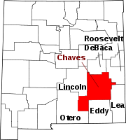
Towns Dexter | Hagerman | Lake Arthur
Ghost town Categories:- Populated places in Chaves County, New Mexico
- Towns in New Mexico


Wikimedia Foundation. 2010.