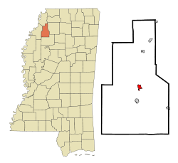
- Marks, Mississippi
-
Marks, Mississippi — City — Location of Marks, Mississippi Coordinates: 34°15′18″N 90°16′22″W / 34.255°N 90.27278°WCoordinates: 34°15′18″N 90°16′22″W / 34.255°N 90.27278°W Country United States State Mississippi County Quitman Area – Total 1.0 sq mi (2.7 km2) – Land 1.0 sq mi (2.7 km2) – Water 0.0 sq mi (0.0 km2) Elevation 161 ft (49 m) Population (2000) – Total 1,551 – Density 1,509.9/sq mi (583.0/km2) Time zone Central (CST) (UTC-6) – Summer (DST) CDT (UTC-5) ZIP code 38646 Area code(s) 662 FIPS code 28-45240 GNIS feature ID 0673138 Marks is a city in Quitman County, Mississippi, United States. As of the 2000 census, the city population was 1,551. It is the county seat of Quitman County[1]. Marks was named for Leopold Marks, a Jewish immigrant trader of the late 19th century whose market became one of the earliest centers of business in the area.[citation needed]
Contents
Geography
Marks is located at 34°15′18″N 90°16′22″W / 34.255°N 90.27278°W (34.254918, -90.272784)[2].
According to the United States Census Bureau, the city has a total area of 1.0 square mile (2.6 km2), all land.
History
Marks is notable for being the starting point of Dr. Martin Luther King Jr's Poor People's Campaign in 1968.[3]
The town of Marks was named after Leopold Marks (born 1851 - died 1910) who left Germany to avoid conscription by the German army. He landed in New York in 1868. He knew no English and arrived with only 27 cents in his pockets.
Nonetheless, Leopold Marks was Quitman County's first representative to the state legislature and served in that capacity for eight years. In 1875 he married; his wife, Pauline Marks, was born in 1852 but her year of death is unknown.
Leopold Marks realized the potential of the Coldwater River region and the dense forests and the fertile banks of Cassidy's Bayou when he bought a small trading boat and peddled goods up and down the river area. He opened his store and began to buy land at $0.40 per acre. He also peddled jewelry across the county until he reached Friars Point, Mississippi.
Prejudice at first kept him from obtaining the land grant that he sought. He was shot at several times. (Source: page 77-78 "Jews of Early Mississippi" published by University Press of Mississippi) He skirted the issue by forming the Marks Townsite Company and did manage to get the grant.
He encouraged the Yazoo and Mississippi Valley Railroad to come into the area by giving the railroad company, without cost, the right-of-way through his plantation plus 10 acres (40,000 m2) of land. Leopold Marks' son, Henry Marks, donated land to the town of Marks to be used as a cemetery.
The official "founding" of the town is considered to be May 12, 1907; on May 12, 2007, the town celebrated its centennial.
Demographics
As of the census[4] of 2000, there were 1,551 people, 579 households, and 387 families residing in the city. The population density was 1,509.9 people per square mile (581.4/km²). There were 643 housing units at an average density of 625.9 per square mile (241.0/km²). The racial makeup of the city was 34.62% White, 64.67% African American, 0.06% Native American, 0.19% Asian, and 0.45% from two or more races. Hispanic or Latino of any race were 0.39% of the population.
There were 579 households out of which 33.0% had children under the age of 18 living with them, 32.0% were married couples living together, 29.2% had a female householder with no husband present, and 33.0% were non-families. 29.7% of all households were made up of individuals and 13.0% had someone living alone who was 65 years of age or older. The average household size was 2.55 and the average family size was 3.16.
In the city the population was spread out with 28.7% under the age of 18, 8.4% from 18 to 24, 26.8% from 25 to 44, 16.7% from 45 to 64, and 19.3% who were 65 years of age or older. The median age was 35 years. For every 100 females there were 81.6 males. For every 100 females age 18 and over, there were 73.1 males.
The median income for a household in the city was $20,521, and the median income for a family was $27,153. Males had a median income of $25,100 versus $16,985 for females. The per capita income for the city was $11,104. About 26.1% of families and 30.3% of the population were below the poverty line, including 39.9% of those under age 18 and 27.7% of those age 65 or over.
Education
The City of Marks is served by the Quitman County School District.
References
- ^ "Find a County". National Association of Counties. http://www.naco.org/Counties/Pages/FindACounty.aspx. Retrieved 2011-06-07.
- ^ "US Gazetteer files: 2010, 2000, and 1990". United States Census Bureau. 2011-02-12. http://www.census.gov/geo/www/gazetteer/gazette.html. Retrieved 2011-04-23.
- ^ http://poorpeoplescampaignppc.org/
- ^ "American FactFinder". United States Census Bureau. http://factfinder.census.gov. Retrieved 2008-01-31.
External links
- Re-enactment of anti-poverty march to begin in Marks -- Clarksdale Press Register, Aug 1 '03[dead link]
Municipalities and communities of Quitman County, Mississippi City Marks
Towns Unincorporated
communitiesAllen | Barksdale | Belen | Birdie | Bobo | Chancy | Darling | Denton | Essex | Hinchcliff | Locke Station‡ | Longstreet | Oliverfried | Riverview | Sabino | Vance‡ | Walnut | West Marks | Yarbrough
Former settlement Ingram‡
Footnotes ‡This populated place also has portions in an adjacent county or counties
Categories:- Cities in Mississippi
- Populated places in Quitman County, Mississippi
- County seats in Mississippi
- Populated places in Mississippi with African American majority populations
Wikimedia Foundation. 2010.


