- Credit River Township, Scott County, Minnesota
-
Credit River Township, Minnesota — Township — Location within the state of Minnesota
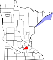
 Credit River Township, Minnesota
Coordinates: 44°41′23″N 93°21′24″W / 44.68972°N 93.35667°WCoordinates: 44°41′23″N 93°21′24″W / 44.68972°N 93.35667°W Country United States State Minnesota County Scott Area – Total 23.9 sq mi (61.8 km2) – Land 23.4 sq mi (60.7 km2) – Water 0.4 sq mi (1.1 km2) Elevation 984 ft (300 m) Population (2000) – Total 3,895 – Density 166.1/sq mi (64.1/km2) Time zone Central (CST) (UTC-6) – Summer (DST) CDT (UTC-5) FIPS code 27-13726[1] GNIS feature ID 0663886[2] Credit River Township is a township in Scott County, Minnesota, United States. The population was 3,895 at the 2000 census. The Credit River flows northwardly through the township.[3]
Contents
Geography
According to the United States Census Bureau, the township has a total area of 23.9 square miles (62 km2), of which, 23.5 square miles (61 km2) of it is land and 0.4 square miles (1.0 km2) of it (1.72%) is water.
Demographics
As of the census[1] of 2000, there were 3,895 people, 1,242 households, and 1,105 families residing in the township. The population density was 166.1 people per square mile (64.1/km²). There were 1,252 housing units at an average density of 53.4/sq mi (20.6/km²). The racial makeup of the township was 98.18% White, 0.28% African American, 0.28% Native American, 0.74% Asian, 0.10% from other races, and 0.41% from two or more races. Hispanic or Latino of any race were 0.56% of the population.
There were 1,242 households out of which 48.3% had children under the age of 18 living with them, 81.7% were married couples living together, 3.7% had a female householder with no husband present, and 11.0% were non-families. 7.7% of all households were made up of individuals and 1.0% had someone living alone who was 65 years of age or older. The average household size was 3.13 and the average family size was 3.29.
In the township the population was spread out with 31.6% under the age of 18, 6.0% from 18 to 24, 31.0% from 25 to 44, 27.4% from 45 to 64, and 4.0% who were 65 years of age or older. The median age was 37 years. For every 100 females there were 103.2 males. For every 100 females age 18 and over, there were 106.7 males.
The median income for a household in the township was $78,501, and the median income for a family was $79,852. Males had a median income of $55,739 versus $38,000 for females. The per capita income for the township was $29,567. About 2.2% of families and 3.1% of the population were below the poverty line, including 5.7% of those under age 18 and 2.6% of those age 65 or over.
See also
- Credit River Case - a court case named after this township
References
- ^ a b "American FactFinder". United States Census Bureau. http://factfinder.census.gov. Retrieved 2008-01-31.
- ^ "US Board on Geographic Names". United States Geological Survey. 2007-10-25. http://geonames.usgs.gov. Retrieved 2008-01-31.
- ^ Minnesota Atlas & Gazetteer. Yarmouth, Me.: DeLorme. 1994. pp. 33. ISBN 0-89933-222-6.
External links
Municipalities and communities of Scott County, Minnesota Cities Belle Plaine | Elko New Market | Jordan | New Prague‡ | Prior Lake | Savage | Shakopee
Townships Belle Plaine | Blakeley | Cedar Lake | Credit River | Helena | Jackson | Louisville | New Market | Sand Creek | Spring Lake | St. Lawrence
Unincorporated
communitiesSpring Lake | Union Hill
Indian
reservationFootnotes ‡This populated place also has portions in an adjacent county or counties
Categories:- Townships in Scott County, Minnesota


Wikimedia Foundation. 2010.