- Donaldson, Minnesota
-
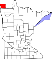
Donaldson, Minnesota — City — Location of Donaldson, Minnesota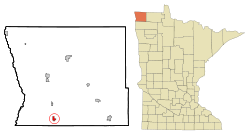
Coordinates: 48°34′21″N 96°53′44″W / 48.5725°N 96.89556°W Country United States State Minnesota County Kittson Area – Total 0.8 sq mi (2.1 km2) – Land 0.8 sq mi (2.1 km2) – Water 0.0 sq mi (0.0 km2) Elevation 827 ft (252 m) Population (2010)[1] – Total 42 – Density 52.5/sq mi (20.0/km2) Time zone Central (CST) (UTC-6) – Summer (DST) CDT (UTC-5) ZIP code 56720 Area code(s) 218 FIPS code 27-16030[2] GNIS feature ID 0642883[3] Donaldson is a city in Kittson County, Minnesota, USA. The population was 42 at the 2010 census.[1]
U.S. Route 75 and Minnesota State Highway 11 are two of the main arterial routes in the community.
Geography
According to the United States Census Bureau, the city has a total area of 0.8 square miles (2.1 km2), all of it land.
Demographics
Historical populations Census Pop. %± 1910 132 — 1920 167 26.5% 1930 133 −20.4% 1940 120 −9.8% 1950 128 6.7% 1960 64 −50.0% 1970 69 7.8% 1980 84 21.7% 1990 57 −32.1% 2000 41 −28.1% 2010 42 2.4% U.S. Decennial Census As of the census[2] of 2000, there were 41 people, 18 households, and 10 families residing in the city. The population density was 49.6 people per square mile (19.1/km²). There were 22 housing units at an average density of 26.6 per square mile (10.2/km²). The racial makeup of the city was 97.56% White, and 2.44% from two or more races. Hispanic or Latino of any race were 2.44% of the population.
There were 18 households out of which 27.8% had children under the age of 18 living with them, 38.9% were married couples living together, 11.1% had a female householder with no husband present, and 38.9% were non-families. 38.9% of all households were made up of individuals and 11.1% had someone living alone who was 65 years of age or older. The average household size was 2.28 and the average family size was 3.00.
In the city the population was spread out with 26.8% under the age of 18, 4.9% from 18 to 24, 34.1% from 25 to 44, 29.3% from 45 to 64, and 4.9% who were 65 years of age or older. The median age was 39 years. For every 100 females there were 141.2 males. For every 100 females age 18 and over, there were 172.7 males.
The median income for a household in the city was $26,875, and the median income for a family was $34,375. Males had a median income of $31,250 versus $16,250 for females. The per capita income for the city was $11,637. There are 18.2% of families living below the poverty line and 7.7% of the population, including no under eighteens and none of those over 64.
References
- ^ a b "2010 Census Redistricting Data (Public Law 94-171) Summary File". American FactFinder. U.S. Census Bureau, 2010 Census. http://factfinder2.census.gov/faces/tableservices/jsf/pages/productview.xhtml?pid=DEC_10_PL_GCTPL2.ST13&prodType=table. Retrieved 23 April 2011.
- ^ a b "American FactFinder". United States Census Bureau. http://factfinder.census.gov. Retrieved 2008-01-31.
- ^ "US Board on Geographic Names". United States Geological Survey. 2007-10-25. http://geonames.usgs.gov. Retrieved 2008-01-31.
Municipalities and communities of Kittson County, Minnesota Cities Donaldson | Hallock | Halma | Humboldt | Karlstad | Kennedy | Lake Bronson | Lancaster | St. Vincent
Townships Unorganized
territoriesUnincorporated
communityGhost towns Coordinates: 48°34′20″N 96°53′47″W / 48.57222°N 96.89639°W
Categories:- Cities in Minnesota
- Populated places in Kittson County, Minnesota


Wikimedia Foundation. 2010.