- Diamond Lake (Oregon)
-
Diamond Lake 
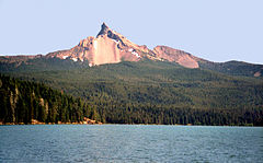
Lake with Mt. Thielsen in the background Location Douglas County, Oregon, USA Coordinates 43°09′31″N 122°09′03″W / 43.15861°N 122.15083°W Basin countries United States Max. length 3.5 mi (5.6 km) Max. width 1.5 mi (2.4 km) Surface area 2,824 acres (11.43 km2) Max. depth 52.5 ft (16.0 m) Surface elevation 5,183 ft (1,580 m) Diamond Lake is a lake in the southern part of the U.S. state of Oregon. It lies near the junction of Oregon Route 138 and Oregon Route 230 in the Umpqua National Forest in Douglas County. It is located between Mount Bailey to the west and Mount Thielsen to the east; it is just north of Crater Lake National Park.
The outlet of the lake is at its north end. From there, water flows via Lake Creek into the North Umpqua River and ultimately to the Pacific Ocean.[1]
Diamond Lake was named for John Diamond, for whom Diamond Peak is also named.[2] He discovered the lake in 1852 while on the summit of Diamond Peak.[2] Diamond was a pioneer settler of Coburg, Oregon who was part of a party that was opening a road between the Middle Fork Willamette River and Idaho as an immigration route.[2]
The post office of Diamond Lake, Oregon was established in 1925 and ran until 1956, when it was changed to a summer-only office.[2]
Contents
Invasive species
Diamond Lake has been known as one of the most desired fishing lakes in Southern Oregon, famous for its large rainbow trout, although the species is not native to the lake.[3] In 1992, another non-native species tui chub were detected in the lake. These fish, presumed to have been introduced illegally as bait for the trout,[citation needed] grew quickly in population, and had a strong negative impact on the lake's ecology. In what once was a "showcase trout fishery", the lake's water became murky,[citation needed] trout declined, and the insect population dropped dramatically. This had also happened at the lake in 1954.[3]
The Oregon Department of Fish and Wildlife poisoned the lake with Rotenone[4] in 2006 to kill off the tui chub and restore balance to the ecosystem. The project was more successful than anticipated; in 2007 dramatic improvements were noted.[5]
While monitoring current fish populations in 2008 the Oregon Department of Fish and Wildlife discovered a population of golden shiners which is an invasive species to the lake. Through electrofishing 639 fish have been removed so far. The Oregon State Police is currently investigating how the fish were introduced into the lake.[6]
Fishing
Fishing on Diamond Lake is best on the shallow waters of the south end near Silent Creek[7][8] as well as in the deep water areas of the north end of the lake. Bank fishing is also productive accessible by several trails around the lake. Bank fishing opportunities can also be found around the Diamond Lake Resort, near Lake Creek and along the US Forest Service campgrounds.[9] Fishing is good throughout the seaseon with some of the best fishing being reported from the end of April through May and in the fall around the time the fishing season closes.
There are five boat ramps around the lake, all of which have paved access. The speed limit on the lake is 10 mph. Trolling for rainbow trout using rooster tails, crocodiles and super dupers are some of the most productive methods reported on Diamond Lake.[9] Anglers have used a variety of spinners and lures. Anchored near Silent Creek or Lake Creek fishing is reportedly effective by use of woolly-buggers and black ants or PowerBait.[9] As with other freshwater fisheries, the use of live fish is banned on Diamond Lake.
Hiking
Some of the trails around Diamond Lake lead to hiking to the summits of nearby Mt Bailey and Mt Thielsen. The Pacific Crest trail and Crater Lake are also near the lake.[9] Wildlife viewing and birdwatching are productive around the lake and the surrounding mountains. One of the trails around the lake has a paved bike route 11 miles long. The US Forest Service permits snowmobiling and backcountry skiing through the winter months. The Joseph H. Stewart State Recreation Area is the closest state park to Diamond Lake.
Campgrounds and resorts
The United States Forest Service currently operates three campgrounds in the area surrounding Diamond Lake: the original campground, Diamond Lake, and two newer additions, Thielsen View Campground and Broken Arrow Campground.[10]
Private owners constructed the Diamond Lake Resort in the early twentieth century and it is still operating today. The north shore resort consists of a motel, cabins, restaurant, boat house and a small store selling grocery items and gift items. On the south shore of the lake there is another small store and a pizza parlor, South Shore Pizza.[11]
The Diamond Lake Resort sees its busiest times of year in the winter and summer. Winter activities include snowmobiling, snow skiing,and iceskating. Summer activities include fishing, swimming, horseback riding and camping.[11]
References
- ^ U.S. Geological Survey topographic maps
- ^ a b c d McArthur, Lewis A.; Lewis L. McArthur (2003) [1928]. Oregon Geographic Names (Seventh Edition ed.). Portland, Oregon: Oregon Historical Society Press. pp. 288, 289. ISBN 0-87595-277-1.
- ^ a b Oregon Department of Fish and Wildlife
- ^ DFW Diamond Lake page
- ^ Associated Press (October 29, 2007). "Oregon anglers flock back to revived lake". The Seattle Times. http://seattletimes.nwsource.com/html/outdoors/2003981187_weboregonlake29.html.
- ^ [1]
- ^ "How To Fish Diamond Lake". How-To-Fish.com. http://www.how-to-fish.com/how_to_fish_diamond_lake.htm. Retrieved 29 July 2011.
- ^ "DIAMOND LAKE FISHING REPORT". DiamondLake.net Fishing Reports. http://www.diamondlake.net/fishingreport.html. Retrieved 29 July 2011.
- ^ a b c d "Diamond Lake". Oregon Department of Fish and Wildlife. http://www.dfw.state.or.us/fish/easy_angling/southwest/diamondlake.asp. Retrieved 29 July 2011.
- ^ US Forest Service Website
- ^ a b Diamond Lake Resort Homepage
External links
- Diamond Lake FAQ from Douglas County website
 Media related to Diamond Lake at Wikimedia CommonsCategories:
- Lakes of Oregon
- Landforms of Douglas County, Oregon
Wikimedia Foundation. 2010.

