- Meadow, South Dakota
-
Meadow, South Dakota — Township — Coordinates: 45°30′10″N 102°15′35″W / 45.50278°N 102.25972°WCoordinates: 45°30′10″N 102°15′35″W / 45.50278°N 102.25972°W Country United States State South Dakota County Perkins Area – Total 35.8 sq mi (92.8 km2) – Land 35.6 sq mi (92.1 km2) – Water 0.3 sq mi (0.7 km2) Elevation 2,703 ft (824 m) Population (2000) – Total 35 – Density 1.0/sq mi (0.4/km2) Time zone Mountain (MST) (UTC-7) – Summer (DST) MDT (UTC-6) ZIP code 57644 Area code(s) 605 FIPS code 46-41660[1] GNIS feature ID 1269126[2] Meadow is an unincorporated community in Perkins County, South Dakota, United States. Meadow is twelve miles east of Bison and two miles from the junction of South Dakota Highways 20 and 73. Although not tracked by the Census Bureau, Meadow has been assigned the ZIP code of 57644. There is a post office located within the town of Meadow. The surrounding area is farming and ranching land.
Meadow is located approximately 25 kilometres to the west from the farthest point from any McDonald’s restaurant in the contiguous United States 45°27′34″N 101°54′49″W / 45.45955°N 101.91356°W[3]. Along with Glad Valley, South Dakota, Meadow is one of the nearest communities to that point.
References
- ^ "American FactFinder". United States Census Bureau. http://factfinder.census.gov. Retrieved 2008-01-31.
- ^ "US Board on Geographic Names". United States Geological Survey. 2007-10-25. http://geonames.usgs.gov. Retrieved 2008-01-31.
- ^ Von Worley, Stephen. "Where The Buffalo Roamed". Weather Sealed. http://www.weathersealed.com/2009/09/22/where-the-buffalo-roamed/. Retrieved September 23, 2009.
Municipalities and communities of Perkins County, South Dakota City 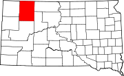
Town Townships Ada | Anderson | Antelope | Barrett | Beck-Highland | Bison | Burdick | Cash | Castle Butte | Chaudoin | Clark | De Witt | Duell | Englewood | Flat Creek | Flint Rock | Foster | Fredlund | Glendo | Grand River | Hall | Horse Creek | Liberty | Lincoln | Lodgepole | Lone Tree | Maltby | Marshfield | Meadow | Moreau | Plateau | Rainbow | Rockford | Scotch Cap | Sidney | Strool | Trail | Vail | Vickers | Viking | Vrooman | Wells | White Butte | Wilson
Unincorporated
communitiesChance | Coal Springs | Date | Imogene | Lodgepole | Meadow | Prairie City | Shadehill | Sorum | Strool | Summerville | Usta | White Butte | Zeona
Categories:- Populated places in Perkins County, South Dakota
- Unincorporated communities in South Dakota
- South Dakota geography stubs

Wikimedia Foundation. 2010.