- Atarot Airport
-
Atarot Airport
Jerusalem International Airport (CLOSED)
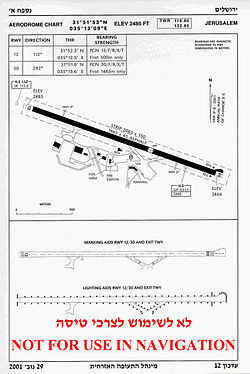
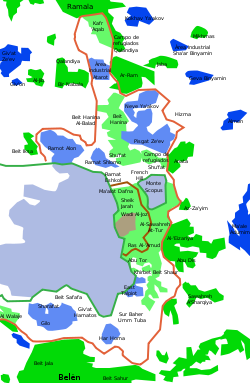
שדה התעופה ירושליםIATA: JRS – ICAO: LLJR, OJJR Summary Airport type Military/Public Operator Israel Defense Forces Location Jerusalem Elevation AMSL 2,485 ft / 757 m Coordinates 31°51′53″N 35°13′09″E / 31.86472°N 35.21917°E Runways Direction Length Surface ft m 12/30 6,447 1,965 Asphalt Atarot Airport (IATA: JRS, ICAO: LLJR, OJJR), (also Kalandia Airport) is a small airport located between Jerusalem and Ramallah. It was the first airport in Mandate Palestine. It has been closed since the Second Intifada.[1]
Contents
History
Until 1930, the airfield in Kalandia was the only airport in Palestine. It was used by the British military authorities and prominent guests bound for Jerusalem. [2]
The airport was located near Atarot, a Jewish village captured and destroyed by the Jordanian Arab Legion during the 1948 Arab-Israeli War, and to the Arab village of Kalandia (after 1948, also a refugee camp of the same name). Both had at different times, and under different political circumstances, given their name to the airport.
The airport was controlled by Jordanian troops from 1948 until the Six-Day War in June 1967, after which it was unilaterally incorporated into the Greater Jerusalem municipal area.
In the 1970s and early 1980s the Israeli authorities invested considerable resources in upgrading the airport and creating the infrastructure for a full-fledged international airport, which was intended to become the equal of Israel's Ben Gurion Airport. However, such efforts run afoul of the area's disputed international position. International bodies in general and international aviation authorities in particular proved unwilling to recognize it as part of Israel - its ambiguous situation reflected in having two divergent ICAO codes (see below).
As a result, the landing of international airplanes at Atarot was considered a controversial political act which established airlines shied away from, and were actively pressured by their governments not to take. Therefore, the airport was only used sparsely by occasional charter flights and domestic Israeli ones, which did not provide an economic justification for its operation. For some years, it was operated at a considerable loss, borne by the government for purely political reasons.
Its position was further undermined by the First Intifada of 1987, giving the area - thickly populated by Palestinians in nearby Ramallah and various villages, towns and neighborhoods - a "dangerous" reputation and making Israeli Jerusalemites prefer Ben Gurion Airport even for domestic flights.
The Second Intifada of 2000 delivered the coup de grace. As noted at the time by journalist Larry Derfner (see external link below), in the early months of the Intifada the airport's runaways became covered with "thousands of stones" thrown by Palestinians, an obvious grave hazard to any air traffic.
In 2001, the Israel Defense Forces closed the airport to civilian air traffic and took it over for military use - not by the Israeli Air Force but rather as a base for ground troops involved in confrontations with the Palestinians.[3]
In maps presented by Israel at the Camp David talks in the summer of 2000, Atarot was included in the Israeli built-up area of Jerusalem.[4] This was firmly rejected by the Palestinian delegation, which claimed the place as the future Palestinian National Airport, to serve Palestinian East Jerusalem and the whole of the West Bank. This was one aspect of the disagreements which caused the Camp David talks' collapse and the descent into violence and bloodshed.
Yossi Beilin, at the time an Israeli government minister and senior negotiatiator, later a peace activist and founder of the Geneva Initiative, proposed that the airport be used jointly by Israel and Palestine, as part of an overall sharing of Jerusalem. Beilin cited the successful model of Geneva International Airport, which is used by both Switzerland and France. While Palestinians did not reject this idea out of hand, the Israeli governments headed by Sharon, Olmert and Netanyahu were all cool to it.
On 29 December 2009 the Palestinian Authority cabinet under Salam Fayyad announced its intentition to claim the Kalandia Airport for the future State of Palestine, which Fayyad aims to bring into being by 2011.[5]
A future new revenant Jewish neighbourhood has been suggested on the land of the current airport.
ICAO codes
The airport is sometimes shown with two different ICAO codes. The LL designator is used by ICAO for airports in Israel and OJ is the code for Jordan.
See also
References
- ^ Larry Derfner (2001-01-23). "An Intifada Casualty Named Atarot". The Jewish Journal of Greater Los Angeles. http://www.jewishjournal.com/home/preview.php?id=6648. Retrieved 2007-11-07 An Intifada Casualty Named Atarot.
- ^ An Empire in the Holy Land: Historical Geography of the British Administration of Palestine, 1917-1929 Gideon Biger, St. Martin's Press and Magnes Press, New York & Jerusalem, 1994, p. 152
- ^ Atarot Airport handed over to the IDF
- ^ Atarot and the fate of the Jerusalem airport
- ^ PA cabinet discusses airport location
Airports Border Terminals Egypt: Nitzana · Taba
Gaza Strip: Karni · Kerem Shalom
Jordan: Allenby Bridge · Arava · Jordan RiverDefunct/Former Properties  Israeli airports
Italics indicate airports located in the Israeli-occupied territories. International Domestic Bar Yehuda · Be'er Sheva · Eilat · Ein Yahav · Fik · Haifa · Herzliya · Megiddo · Mitzpe Ramon · Rosh Pina Ben Ya'akov · Sde Dov · Yotvata
Military Former Jerusalem Atarot · Kiryat Shmona

This geography of the Palestinian territories article is a stub. You can help Wikipedia by expanding it.


