- Yasser Arafat International Airport
Infobox Airport
name = Yasser Arafat International Airport (CLOSED)
nativename =
nativename-a = مطار ياسر عرفات الدولي
nativename-r =
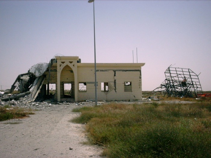
image-width =
caption =
IATA = GZA
ICAO = LVGZ
type = Public
owner =
operator = Yaser Arafat International Airport
city-served =
location = Gaza Strip
elevation-f = 320
elevation-m = 98
coordinates = Coord|31|14|47|N|34|16|34|E|type:airport|display=inline,title
website =
metric-elev =
metric-rwy =
r1-number = 01/19
r1-length-f = 10,091
r1-length-m = 3,076
r1-surface =Asphalt
stat-year =
stat1-header =
stat1-data =
stat2-header =
stat2-data =
footnotes =Yasser Arafat International Airport ( _ar. مطار ياسر عرفات الدولي; transliterated: Matar Yasir 'Arafat ad-Dowaly) airport codes|GZA|LVGZ, formerly Gaza International Airport and Dahaniya International Airport, is located in the
Gaza Strip , inRafah close to theEgypt ian border.It is owned, and was operated, by the
Palestinian Authority , and served as the home airport forPalestinian Airlines . The airport was able to handle 700,000 passengers per year and operated 24 hours and 364 days a year (closed on Yom Kippur). The airport opened in 1998, but it closed in 2001 after being severely damaged byIsrael i military forces.History
The airport was built with funding from
Japan ,Egypt ,Saudi Arabia ,Spain , andGermany and designed byMoroccan architect s (modeled after Casablanca airport) and engineers funded by Morocco'sKing Hassan II . The total cost was $86 million. After a year of construction, it opened on24 November ,1998 ; attendees at the opening ceremony includedYasser Arafat and US PresidentBill Clinton . At the time, the opening of the airport was described as evidence of progress toward Palestinian statehood. [Palestinians cheer airport as first step to statehood,Associated Press , November 25, 1998.] The airport was twinned withMohammed V International Airport , inCasablanca ,Morocco .The radar station and control tower were destroyed by
Israel Defense Forces aircraft in 2001 after the start of theal-Aqsa Intifada , and bulldozers cut the runway apart in January 2002. [ [http://msnbc.msn.com/id/7900217/ Grounded in Gaza, but hoping to fly again] ,MSNBC , May 19 2005, Retrieved on July 2nd 2006] [http://news.bbc.co.uk/1/hi/world/middle_east/4449461.stm Years of delays at Gaza airport] , Johnston, Alan. "BBC News ", April 15 2005, Retrieved on July 2nd 2006] The Israeli attack on the airport was motivated by Israeli concerns that they could not control what thePalestinian Authority transported in or out of the Gaza Strip, such as weapons, and to punish Arafat's government for its support of terrorism. [Mitch Potter, Gaza yearns to fly again, "The Toronto Star", January 23, 2005.]From 2001 to 2006, airport staff still manned the ticket counters and baggage areas, though no aircraft flew into or out of the airport during that period. The closest airport in the area is
El Arish International Airport inEgypt .Runways
The airport has one runway of 3080 m x 60 m, but it is no longer operational due to extensive damage to the north and middle sections of the runway. Some of the taxiways are damaged, but the apron did not sustain heavy damage.
Buildings and Terminal
The main terminal building is a two story 4,000 square metre Arab Islamic designed building and decorated with Moroccan tile, glass windows framed by arches and has state-of-the-art equipment. A control tower faces the runway and apron.
The airport was staffed by a total of 400 personnel.
There were no ramps for passengers to disembark directly to the terminal. Stairs were brought out to the planes parked on the apron.
Facilities within the terminal building included:
* VIP Lounge
* Baggage Area
* Customs and Immigration
* 2 Restaurants
* Medical Facilities
* First Aid Clinic
* Bank
* Post office
* Tourist Office
* Security OfficeThere were 19 other buildings at the airport including:
* Fuel Stations - Palestinian Petroleum Corporation
* Aircraft Hangars
* ATS Communication Tower - destroyed
* Passenger Services
* Cargo Terminals
* Airline Operations (Ground Services)
* Fire and Rescue
* Parking Lot
* Maintenance Workshop
* 28 Metres ATC watchtowerGround transportation
The airport was linked by buses and taxis to the rest of the
Gaza Strip .Airlines
A list of airlines once operating at the airport:
*
Egypt Air
*Palestinian Airlines
*Royal Air Maroc
*Royal Jordanian
*Royal Wings
*Rusavia
*Tarom Air Traffic Control
Locally Air Traffic Control at YAIA was maintained by the Palestinian Authority Civil Aviation Authority, but traffic to and from was also under the jurisdiction of the
Israel South Control .References
External links
* [http://www.arafat-airport.ps Yasser Arafat International Airport Official website]
* [http://maps.google.com/maps?f=q&hl=en&geocode=&time=&date=&ttype=&ie=UTF8&ll=31.242086,34.271593&spn=0.032069,0.058365&t=k&z=14&om=1 Google Maps aerial photograph]
Wikimedia Foundation. 2010.