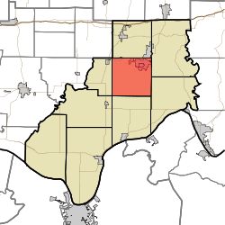
- Clay Township, Spencer County, Indiana
-
Clay Township — Township — Coordinates: 38°04′25″N 86°57′16″W / 38.07361°N 86.95444°WCoordinates: 38°04′25″N 86°57′16″W / 38.07361°N 86.95444°W Country United States State Indiana County Spencer Government - Type Indiana township Area - Total 37.27 sq mi (96.54 km2) - Land 36.69 sq mi (95.04 km2) - Water 0.58 sq mi (1.5 km2) Elevation[1] 449 ft (137 m) Population (2000) - Total 2,494 - Density 67.97/sq mi (26.24/km2) FIPS code 18-13240[2] GNIS feature ID 453219 Clay Township is one of nine townships in Spencer County, Indiana. As of the 2000 census, its population was 2,494.
References
- ^ "US Board on Geographic Names". United States Geological Survey. 2007-10-25. http://geonames.usgs.gov. Retrieved 2008-01-31.
- ^ "American FactFinder". United States Census Bureau. http://factfinder.census.gov. Retrieved 2008-01-31.
External links
Municipalities and communities of Spencer County, Indiana County seat: Rockport City Towns Chrisney | Dale | Gentryville | Grandview | Richland City | Santa Claus
Townships Unincorporated
communitiesAfrica | Bloomfield | Buffaloville | Centerville | Clay City | Enterprise | Eureka | Evanston | Fulda | Hatfield | Huffman | Kennedy | Lake Mill | Lamar | Liberal | Lincoln City | Mariah Hill | Maxville | Midway | New Boston | Newtonville | Patronville | Pueblo | Reo | Rock Hill | Rockport Junction | Saint Meinrad | Sand Ridge | Santa Fe | Schley | Silverdale
Categories:- Townships in Spencer County, Indiana
- Southern Indiana geography stubs
Wikimedia Foundation. 2010.

