- Grandview, Indiana
Infobox Settlement
official_name = Town of Grandview, Indiana
settlement_type =Town
nickname =
mapsize = 250x200px
imagesize =
image_caption =
imagesize =
image_caption =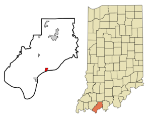
map_caption = Location in the state ofIndiana
mapsize1 =
map_caption1 =
subdivision_type = Country
subdivision_name =United States
area_footnotes =
unit_pref = Imperial
subdivision_type1 = State
subdivision_name1 =Indiana
subdivision_type2 = County
subdivision_name2 = Spencer
subdivision_type3 = Township
subdivision_name3 = Hammond
government_type =
leader_title =
leader_name =
established_date =
area_magnitude = 1 E6
area_total_km2 = 2.5
area_land_km2 = 2.5
area_water_km2 = 0.0
population_as_of = 2000
population_note =
population_total = 696
population_density_km2 = 279.9
timezone = CST
utc_offset = -6
timezone_DST = CDT
utc_offset_DST = -5
area_total_sq_mi = 1.0
area_land_sq_mi = 1.0
area_water_sq_mi = 0.0
elevation_m = 120
elevation_ft = 394
latd = 37 |latm = 56 |lats = 8 |latNS = N
longd = 86 |longm = 59 |longs = 5 |longEW = W
postal_code_type =ZIP code
postal_code = 47615
area_code = 812
blank_name = FIPS code
blank_info = 18-28692GR|2
blank1_name = GNIS feature ID
blank1_info = 0449661GR|3
footnotes =
website =Grandview is a town in Hammond Township, Spencer County,
Indiana , along theOhio River . The population was 696 at the 2000 census.The town received its name because of the "grand view" of the Ohio River.
Geography
Grandview is located at coor dms|37|56|8|N|86|59|5|W|city (37.935659, -86.984743)GR|1.
According to the
United States Census Bureau , the town has a total area of 1.0square mile s (2.5km² ), all of it land.Demographics
As of the
census GR|2 of 2000, there were 696 people, 266 households, and 194 families residing in the town. Thepopulation density was 727.5 people per square mile (279.9/km²). There were 296 housing units at an average density of 309.4/sq mi (119.0/km²). The racial makeup of the town was 96.84% White, 1.87% African American, 0.43% Native American, 0.43% Asian, and 0.43% from two or more races. Hispanic or Latino of any race were 0.14% of the population.There were 266 households out of which 36.5% had children under the age of 18 living with them, 57.9% were married couples living together, 12.0% had a female householder with no husband present, and 26.7% were non-families. 22.6% of all households were made up of individuals and 10.2% had someone living alone who was 65 years of age or older. The average household size was 2.62 and the average family size was 3.08.
In the town the population was spread out with 27.4% under the age of 18, 9.1% from 18 to 24, 30.2% from 25 to 44, 22.0% from 45 to 64, and 11.4% who were 65 years of age or older. The median age was 35 years. For every 100 females there were 100.0 males. For every 100 females age 18 and over, there were 89.1 males.
The median income for a household in the town was $35,417, and the median income for a family was $42,727. Males had a median income of $29,732 versus $20,500 for females. The
per capita income for the town was $13,928. About 9.4% of families and 12.0% of the population were below thepoverty line , including 20.0% of those under age 18 and 1.8% of those age 65 or over.ee also
*
List of cities and towns along the Ohio River References
External links
Wikimedia Foundation. 2010.