- Mirboo North, Victoria
-
Mirboo North
Victoria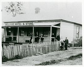
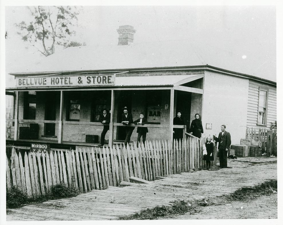
The Mirboo Bellevue Hotel, Store and Post Office ca. 1885-1899
 Mirboo North
Population: 2,688 (2006)[1] Postcode: 3871 Location: LGA: South Gippsland Shire County: Buln Buln State District: Gippsland South Federal Division: Gippsland Localities around Mirboo North: Yarragon Thorpdale Yinnar Korumburra Mirboo North Boolarra Leongatha Foster Mirboo Mirboo North is a town in Victoria, Australia, located 155 kilometres (96 mi) east of Melbourne, with a population of 2688[2]. It is in the South Gippsland Shire local government area.
The town is at the start of the Grand Ridge Rail Trail, which travels for 13km through temperate rainforest and dry sclerophyll forest in the Strzelecki Ranges.
Contents
History
The Mirboo area was settled by timber getters in the late 1870s, attracted particularly by the Mountain Ash. The original railway branch line from Morwell to Mirboo North was completed on 7 January 1886, with the last train being run on 22 June 1974. The railway was constructed through difficult hilly terrain requiring construction of massive embankments and numerous bridges. The convoluted history of the Post Office below demonstrates the attempts to form a viable Mirboo township, culminating in the township of Mirboo North at the railway station becoming predominant.
- 8/1/1879 Mirboo (1) opened
- 22/11/1879 Tarwin (1) opened
- 6/4/1881 Mirboo North (1) renamed from Mirboo, Mirboo (2) renamed from Tarwin
- 29/6/1885 Mirboo South (1) renamed from Mirboo, Mirboo (3) opened
- 1/4/1886 Baromi renamed from Mirboo North (closed 1892), Mirboo North (2) renamed from Mirboo (remains open), Mirboo (4) renamed from Mirboo South (closed 1972)
- 1/5/1888 Mirboo Central opened (closed 1895)
- c.1902 Russell's (Mirboo South) opened (closed c.1904)
Mirboo North became the focus of Victorian media on 10 August 2005, when about 15cm of snow fell. The snow lay around for days.
The Town today
Mirboo North sits on the Grand Ridge Road, a scenic route running from Seaview (near Warragul) to Carrajung (near Traralgon).
The town has two schools. Mirboo North Secondary College (~450 students) and Mirboo North Primary School.
The town has an Australian Rules football team competing in the Mid Gippsland Football League and a cricket team competing in the Central Gippsland Cricket Association.
Golfers play at the course of the Mirboo North Golf Club on Galvins Road.[4]
Notable people and animals
- Belinda Snell (professional basketball player), currently competing in the WNBA for the Phoenix Mercury and a member of the Australian team that won silver at the Beijing Olympics in 2008.
- Sam the Koala found in the forests of Mirboo North, Victoria.
References
- ^ Australian Bureau of Statistics (25 October 2007). "Mirboo North (State Suburb)". 2006 Census QuickStats. http://www.censusdata.abs.gov.au/ABSNavigation/prenav/LocationSearch?collection=Census&period=2006&areacode=SSC26179&producttype=QuickStats&breadcrumb=PL&action=401. Retrieved 2007-10-01.
- ^ Mirboo North profile, accessed 20 July 2007
- ^ Premier Postal History, Post Office List, https://www.premierpostal.com/cgi-bin/wsProd.sh/Viewpocdwrapper.p?SortBy=VIC&country=, retrieved 2008-04-11
- ^ Golf Select, Mirboo North, http://www.golfselect.com.au/armchair/courseView.aspx?course_id=297, retrieved 2009-05-11
Coordinates: 38°24′S 146°09′E / 38.4°S 146.15°E
Towns in the South Gippsland Shire Agnes • Bena • Buffalo • Dumbalk • Fish Creek • Foster • Jumbunna • Kongwak • Koonwarra • Korumburra • Leongatha • Loch • Meeniyan • Mirboo North • Nyora • Poowong • Port Franklin • Port Welshpool • Sandy Point • Stony Creek • Tarwin Lower • Toora • Venus Bay • Walkerville • Waratah Bay • Welshpool • Yanakie •
Categories:- Towns in Victoria (Australia)
- Gippsland

Wikimedia Foundation. 2010.