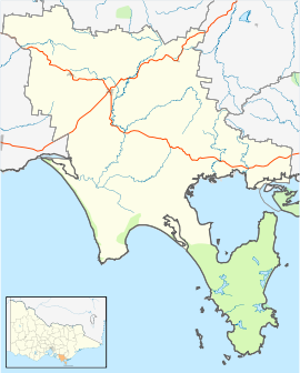
- Meeniyan, Victoria
-
Meeniyan
VictoriaPopulation: 1040 (2006)[1] Postcode: 3956 LGA: South Gippsland Shire County: Buln Buln State District: Gippsland South Federal Division: Gippsland Meeniyan is a small country town on the South Gippsland Highway between Leongatha and Foster.
Contents
History
The Post Office opened on 16 August 1890 shortly before the railway arrived.[2]
The Town today
The town centre is marked by a wide tree-lined median strip [3] and a number of craft and antique shops along both sides.
An annual art and craft show takes place in November, each year.
The town also has a golf course, the Meeniyan Golf Club on Buffalo Road.[4]
Meeniyan is also now known for the filming of Bed of Roses a mini-series on ABC1.
The town in conjunction with neighbouring township Dumbalk has an Australian Rules football team competing in the Alberton Football League.[5]
See also
References
- ^ Australian Bureau of Statistics (25 October 2007). "Meeniyan (State Suburb)". 2006 Census QuickStats. http://www.censusdata.abs.gov.au/ABSNavigation/prenav/LocationSearch?collection=Census&period=2006&areacode=SSC26123&&producttype=QuickStats&breadcrumb=PL&action=401. Retrieved 2008-09-01.
- ^ Premier Postal History, Post Office List, https://www.premierpostal.com/cgi-bin/wsProd.sh/Viewpocdwrapper.p?SortBy=VIC&country=, retrieved 2008-04-11
- ^ Google Street View, tree-lined median strip, http://maps.google.com/maps?q=-38.577095,146.019095&ie=UTF8&ll=-38.577095,146.019095&spn=0.031947,0.053816&z=14&layer=c&cbll=-38.577095,146.019095&panoid=GiuVwGyDDKNwxejuBgGuGw&cbp=1,44.35126646829309,,0,7.419159989179645, retrieved 2008-09-10
- ^ Golf Select, Meeniyan, http://www.golfselect.com.au/armchair/courseView.aspx?course_id=1025, retrieved 2009-05-11
- ^ Full Points Footy, Meeniyan-Dumbalk United, http://www.fullpointsfooty.net/m'yan-dumbalk_utd.htm, retrieved 2008-07-25
External links
References
- ^ Australian Bureau of Statistics (25 October 2007). "Meeniyan (State Suburb)". 2006 Census QuickStats. http://www.censusdata.abs.gov.au/ABSNavigation/prenav/LocationSearch?collection=Census&period=2006&areacode=SSC26123&&producttype=QuickStats&breadcrumb=PL&action=401. Retrieved 2008-09-01.
- ^ Premier Postal History, Post Office List, https://www.premierpostal.com/cgi-bin/wsProd.sh/Viewpocdwrapper.p?SortBy=VIC&country=, retrieved 2008-04-11
- ^ Google Street View, tree-lined median strip, http://maps.google.com/maps?q=-38.577095,146.019095&ie=UTF8&ll=-38.577095,146.019095&spn=0.031947,0.053816&z=14&layer=c&cbll=-38.577095,146.019095&panoid=GiuVwGyDDKNwxejuBgGuGw&cbp=1,44.35126646829309,,0,7.419159989179645, retrieved 2008-09-10
- ^ Golf Select, Meeniyan, http://www.golfselect.com.au/armchair/courseView.aspx?course_id=1025, retrieved 2009-05-11
- ^ Full Points Footy, Meeniyan-Dumbalk United, http://www.fullpointsfooty.net/m'yan-dumbalk_utd.htm, retrieved 2008-07-25
Towns in the South Gippsland Shire Agnes • Bena • Buffalo • Dumbalk • Fish Creek • Foster • Jumbunna • Kongwak • Koonwarra • Korumburra • Leongatha • Loch • Meeniyan • Mirboo North • Nyora • Poowong • Port Franklin • Port Welshpool • Sandy Point • Stony Creek • Tarwin Lower • Toora • Venus Bay • Walkerville • Waratah Bay • Welshpool • Yanakie •
Coordinates: 38°35′S 146°01′E / 38.583°S 146.017°E

This article about a location in Gippsland is a stub. You can help Wikipedia by expanding it.

