- Clifton Heights, St. Louis
-
Clifton Heights
Neighborhoods of St. Louis, Missouri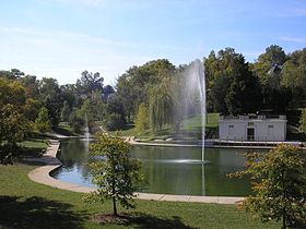
Clifton Heights Lake. Government Country United States State Missouri City St. Louis Wards 23, 24 Statistics Total area 0.48 sq mi (1.2 km2) Population (2010) 3,074[1] Density 6,404 /sq mi (2,473 /km2) Miscellaneous ZIP code(s) Part of 63116 Area code(s) 314 Website http://stlouis.missouri.org/cliftonheights/ Location 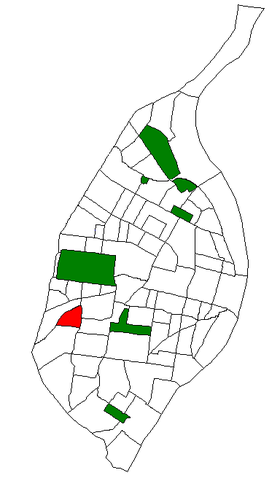
Location of Clifton Heights within St. Louis. Clifton Heights is a neighborhood of St. Louis, Missouri, located along the southwest border of the city and highlighted by a park—Clifton Park (38°36′51″N 90°17′30″W / 38.6143°N 90.2916°W)—with a playground and a lake.
The neighborhood is mostly residential, with a history dating back to the early 19th century and houses of varying architectural styles, including some Victorians and numerous Arts and Crafts homes. The curving streets surrounding the park and the hills that slope downward toward I-44 are somewhat unusual for St. Louis City, and give the neighborhood a distinctive feeling.[citation needed] Bounded on the north and west by I-44, on the east by Hampton Ave., and on the south by Arsenal St., Clifton Heights is located in southwest St. Louis.
Clifton Heights is home to Mason School [2] - an elementary school in the St. Louis Public School System. The neighborhood is in the 24th ward of the City of St. Louis, currently represented by Alderman Scott Ogilvie.[3] The neighborhood holds an annual "Party in the Park" in the fall of each year that features games, crafts, and other family activities. Clifton Heights also features numerous small businesses, a VFW post, and a Drury Inn and Suites at the corner of I-44 and Hampton Avenue that was the subject of much neighborhood controversy regarding the demolition of homes and the placement of a large hotel next to small houses.[4]
References
- ^ Census Summary By Neighborhoods
- ^ St. Louis Public School Services
- ^ City of St. Louis Board of Aldermen: Ward 24 Alderman Scott Ogilvie
- ^ Shawn Clubb, "Hotel developer seeks reprieve from building houses." Southwest City Journal, Nov. 16, 2005. Posted to Urban St. Louis, retrieved June 08, 2009.
Coordinates: 38°36′43″N 90°17′42″W / 38.612°N 90.295°W
Categories:- Neighborhoods in St. Louis, Missouri
- Saint Louis City, Missouri geography stubs


Wikimedia Foundation. 2010.