- New York, Westchester and Boston Railway
-
New York, Westchester and Boston Railway Reporting mark NYWB Locale Bronx, NY to White Plains, NY and Port Chester, New York Dates of operation 1912–1937 Successor New York City Transit Authority (IRT Dyre Avenue Line) Track gauge 4 ft 8 1⁄2 in (1,435 mm) (standard gauge) Headquarters Bronx, New York The New York, Westchester and Boston Railway Company (NYW&BRwy), known to its riders as "the Westchester" and colloquially as the "Boston-Westchester", operated as an electric commuter railroad in the Bronx and Westchester County, New York from 1912 to 1937. It ran from the southernmost part of the Bronx, near the Harlem River to Mount Vernon with a branch north to White Plains and a branch east to Port Chester. From 1906, construction and operation was under the control of the New York, New Haven and Hartford Railroad (the "New Haven") until its bankruptcy in 1935.
A 4-mile (6.4 km) section of this line survives to this day as the IRT Dyre Avenue Line in the New York City Subway system.
Contents
Precursors and origins
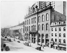 Tammany Hall on East 17th Street, NYC, between Third Avenue and Irving Place

In 1871 the Southern Westchester Railroad was incorporated to run from what was then the southern edge of Westchester County (now the Bronx) at the Harlem River to the Westchester county seat, White Plains, along the same general route to be taken by the NYW&BRwy. By 1875, this enterprise went into foreclosure and was liquidated in 1881. In 1872, the New York, Westchester and Boston Railway Company (NYW&BRwy) was incorporated[1] to run from the Harlem River to Port Chester, New York, to Elmsford, New York west of White Plains, and to Throgs Neck, now in the Bronx. The panic of 1873 denied this venture the financing for construction. It entered receivership on March 20, 1875, not emerging until January 14, 1904.[2]
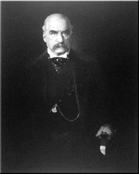
Starting in 1874 portions of Westchester County were made part of New York City, a process that was complete by 1898, with the Bronx in its current configuration. This put much of the NYW&BRwy franchise under the control of the City of New York — meaning the New York Democratic organization, Tammany Hall. In 1901, while the NYW&BRwy still in receivership, the New York and Port Chester Railroad Company (NY&P) was incorporated to build a route from the Harlem River to Port Chester, parallel to the NYW&BRwy route — and the New Haven main line. Meanwhile the NYW&BRwy emerged from receivership on January 14, 1904 and began acquiring additional real estate rights for its route. In 1906 bankers Oakleigh Thorne and Marsden J. Perry bought the stock of the NYW&BRwy on behalf of the Millbrook Company, a holding entity. After the Panic of 1907, the assets of the Millbrook Company were transferred over to the New York, New Haven and Hartford Railroad for $11 million, becoming a part of that company's emerging consolidated monopoly on rail and water transportation in southern New England. A lawsuit between the NY&P and the NYW&BRwy was settled with the NY&P franchise being acquired by the NYW&BRwy in early 1909 and the NY&P being consolidated into the NYW&BRwy the following year. On January 18, 1910, the reorganized entity was consolidated under the control of the New Haven, but inheriting the business arrangements made while under direct control of financier J.P. Morgan.
Construction
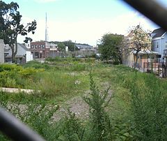
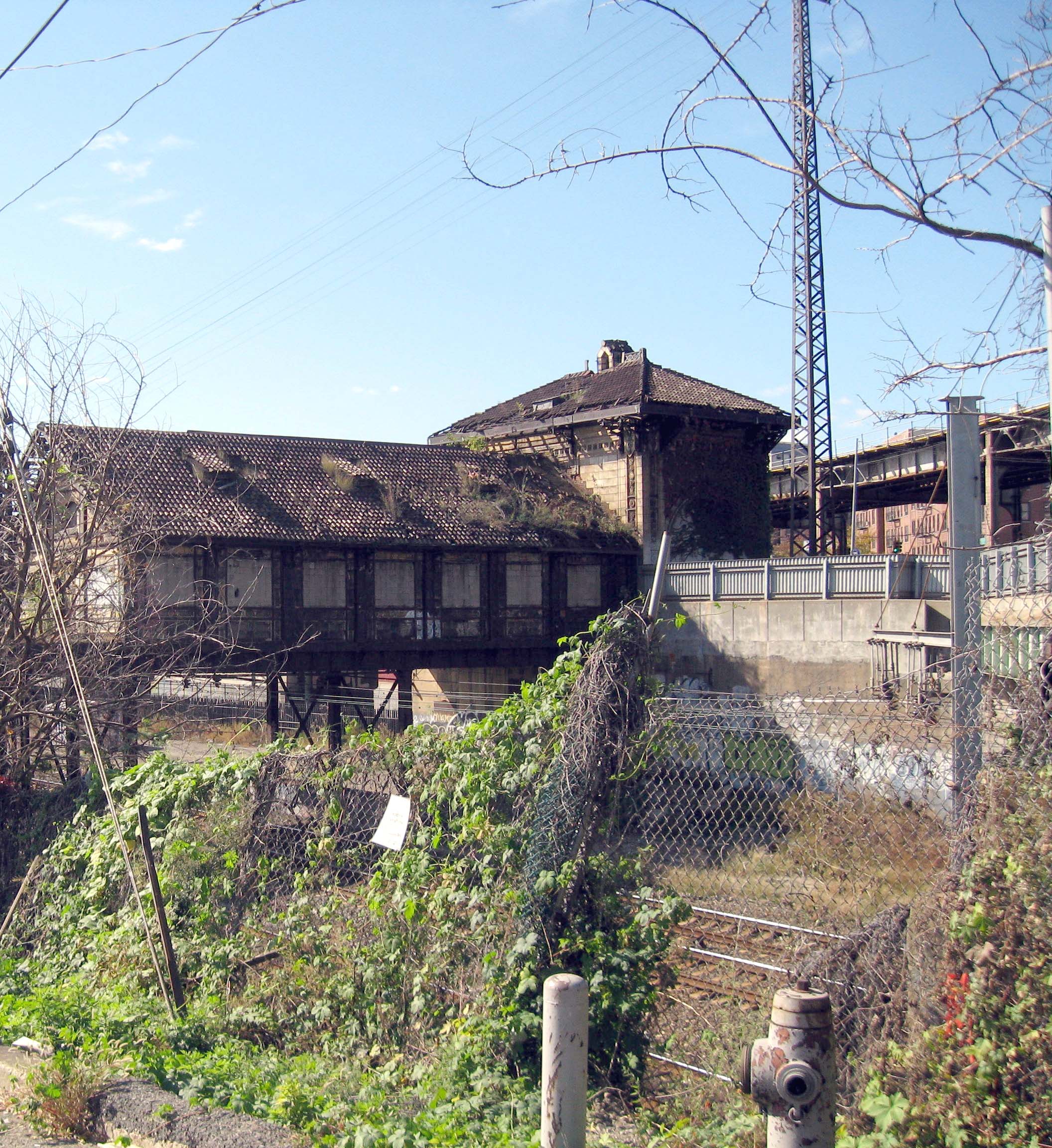
 Abandoned Westchester Avenue station
Construction of the railroad began in 1909. The construction standard to which the NYW&BRwy was built was exceptional from 180th Street to White Plains and through Pelham. Construction (excluding the cost of the NYW&BRR stock) and rolling stock cost more than $1.2 million per mile, an extraordinary amount in 1910. Rails were 90 lb/yd (45 kg/m). Grades were modest, exceeding 1% only to link to the New Haven right of way south of 180th Street. Curves were gentle, exceeding 6 degrees for express tracks only at one location in Mount Vernon which had an 8-degree curve.
The stations along railway were of very attractive cast concrete with marble interiors, and using high platforms for faster passenger loading and unloading. No public roads crossed at grade, which resulted in the construction of many costly bridges, tunnels, and viaducts. From 180th Street to Columbus Avenue the line was four tracks, then double-track to White Plains and Port Chester. Two stations on the White Plains line were four-track stations, although express-train operation using the four-track stations did not prove to be warranted by the traffic volume.
The line extension from New Rochelle to Port Chester was built to a much more economical standard, as exemplified by the wooden platforms and more modest stations. The line was completed as far as Larchmont in 1921, Mamaroneck in 1926, Harrison in 1927, Rye in 1928, and Port Chester in December 1929. An additional station was constructed in White Plains at Ridgeway in 1929 to serve the growing residential area in that neighborhood. Consisting of two side platforms, the wooden construction mimicked what could be found on the Port Chester extension.
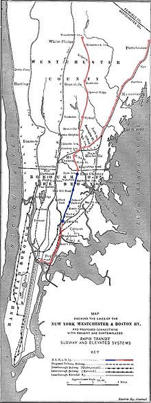
Stations and route
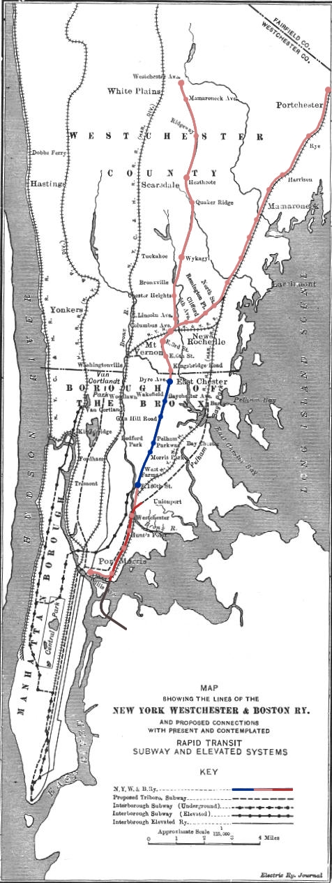
The NYW&BRwy route began at its Harlem River station, located at 132nd Street and Willis Avenue, where an elevated shuttle and later a covered walkway linked it to connected it to the Second and Third Avenue elevated trains of the New York City Transit System and later to the IRT subway line. The NYW&BRwy's tracks ran parallel to the New Haven's tracks, serving four stations also served by New Haven commuter service, to just south of 180th Street, which was the site of the company's headquarters, shops, and yard. 180th Street station was also a major transfer point for passengers taking the New York City Subway. From 180th Street the railroad ran on its own four-track right of way, serving six stations in the Bronx and three in Mount Vernon before its routes divided at Columbus Avenue.
From the Columbus Avenue junction, one line ran north, with one more station in Mount Vernon and stations at Chester Heights in eastern Eastchester, Wykagyl and Quaker Ridge in northern New Rochelle, Heathcote at the border of northern New Rochelle and eastern Scarsdale, Ridgeway, Gedney Way and the Mamaroneck Avenue stations in White Plains, and the White Plains terminal on the eastern edge of downtown at Westchester Avenue and Bloomingdale Road.
The other line went east with the Fifth Avenue station in North Pelham, the Pelhamwood station on New Rochelle/ Pelham border, and the Remington, North Avenue and Pine Brook stations located in central New Rochelle. The route ran on its own tracks located on the New Haven right-of-way from New Rochelle just east of the New Haven's New Rochelle station. The line served the same stations as the New Haven between New Rochelle and Port Chester as well as the Larchmont Gardens station in Larchmont, and the West Street station in Harrison.
Station listing
Milepost City Station Tracks Platform Opening date Connections and notes 0.0 Bronx Harlem River 5 5 High 1912 NYNH&H Harlem River Branch (through 1930)
New York City IRT Third Avenue el0.91 Bronx Port Morris 2 2 Low 1912 NYNH&H Harlem Branch (through 1930) 1.90 Bronx Casenova 2 2 Low 1912 NYNH&H Harlem Branch (through 1930) 2.57 Bronx Hunt's Point 2 2 Low 1912 NYNH&H Harlem Branch (through 1930) 3.19 Bronx Westchester Avenue 2 2 Low 1912 NYNH&H Harlem Branch (through 1930) 4.37 Bronx East 180th Street 4 4 High 1912 New York City IRT White Plains Road Line 5.50 Bronx Morris Park 4 2 High 1912 ? 5.90 Bronx Pelham Parkway 4 4 High 1912 ? 6.74 Bronx Gun Hill Road 4 2 High 1912 ? 7.56 Bronx Baychester Avenue 4 2 High 1912 ? 8.33 Bronx Dyre Avenue 4 2 High 1912 ? 8.63 Mount Vernon Kingsbridge Road 4 2 High 1912 ? 9.24 Mount Vernon East Sixth Street 4 2 High 1912 ? 9.79 Mount Vernon East Third Street 4 4 High 1912 ? 10.27 Mount Vernon Columbus Avenue 4 2 High 1912 NYNH&H at Mount Vernon East 10.66 Mount Vernon East Lincoln Avenue 2 2 High 1912 ? 11.63 Eastchester Chester Heights 2 2 High 1912 ? 13.01 New Rochelle Wykagyl 4 4 High 1912 ? 15.09 New Rochelle Quaker Ridge 2 2 High 1912 ? 15.95 New Rochelle/Scarsdale Heathcote 4 4 High 1912 ? 17.51 White Plains Ridgeway 2 2 High 1912 ? 18.26 White Plains Gedney Way 2 2 High 1912 ? 18.89 White Plains Mamaroneck Avenue 2 2 High 1912 ? 19.50 White Plains Westchester Avenue 4 4 High 1912 Connecting local trolley service 10.95 Pelham Fifth Avenue 2 2 High 1912 ? 11.27 Pelham / New Rochelle Pelhamwood 2 2 High 1912 ? 11.67 New Rochelle Remington (Webster Avenue) 2 2 High 1912 ? 12.17 New Rochelle North Avenue 2 2 High 1921 ? 13.02 New Rochelle Pine Brook 2 2 High 1921 ? 14.03 Larchmont Larchmont (Chatsworth Avenue) 2 2 High 1921 NYNH&H at Larchmont 14.78 Larchmont Larchmont Gardens 2 2 High 1921-6 ? 15.83 Mamaroneck Mamaroneck 2 2 High 1926 NYNH&H at Mamaroneck 16.82 Harrison West Street 2 2 High 1927 ? 17.60 Harrison Harrison 2 2 High 1927 NYNH&H at Harrison 19.44 Rye Rye 2 2 High 1928 NYNH&H at Rye 20.90 Port Chester Port Chester 2 2 High 1929 NYNH&H at Port Chester Proposed extensions
Another New Haven interests company, the Westchester Northern Railroad ("WN"), was chartered in 1910 to build a northward extension of the NYW&BRwy from White Plains to Pound Ridge, with one branch to Danbury, Connecticut and one to Brewster, New York. The NYW&BRwy White Plains terminal was built with this extension in mind. The WN was consolidated with the NYW&BRwy on June 8, 1915. Most activity was limited to acquiring real estate for the right of way, on which no significant construction seems to have taken place. The WN project was officially cancelled by 1925 and the property gradually sold off.
The Harlem Board of Commerce proposed a new connection be built to extend the NYW&BRwy from its Harlem River terminal underground through a new tunnel under the Harlem River and 125th Street, connecting to the Eighth Avenue Line of the Independent Subway ("IND") then under construction. Nothing ever came of this proposal.
The NYW&BRwy crossed the New Haven at a joint station at Columbus Avenue in Mount Vernon. A ramp to the New Haven would have permitted NYW&BRwy trains to run directly to Grand Central. Provisions for such a ramp were designed into the overpass, but no active track connection was ever constructed. The New Haven would have discouraged running trains into Grand Central, since they paid a rental fee to the New York Central for each movement into the terminal.
Competition
With the death of J. P. Morgan in 1913 competition between the New Haven and the New York Central became less restrained. The The NYW&BRwy's White Plains line ran about two miles (3 km) east of route of the Harlem Division of the New York Central. The Harlem Division served the settled towns and villages along the Bronx River. The Harlem Division's commuter trains enjoyed the advantage of running directly into Manhattan. The Port Chester line was on New Haven right of way for more than half of its length and was only two miles west of the New Haven's Harlem River Branch for the balance. Although the New Haven's Harlem Branch trains also terminated at the Harlem River terminal, regular NH commuter trains ran into Grand Central. When the New Haven's bankruptcy led to the separation of ownership of the NYW&BRwy from the New Haven, the New Haven's trustee was able to terminate the NYW&BRwy's lease of its right of way from New Rochelle to Portchester.
The rise of the automobile denied commuter railroads such as the NYW&B the revenue benefits from the growth of the suburbs to whose growth they had contributed. Even the rapid transit connections available at Harlem River and E180th Street were inconvenient compared to the direct service offered by the NYC and the NH to Grand Central Terminal. The great postwar construction boom and explosion of the suburbs would come too late to benefit the Westchester, which shut down in 1937.
Equipment and power
NYW&BRwy was an electric railway that powered its equipment from overhead lines carrying 11,000 volts of alternating current at 25 Hz, the same as the New Haven. The New Haven's Cos Cob plant generated the power, which the NYW&BRwy received at New Rochelle.[3]
The principal rolling stock for the NYW&B were 95 motorized coaches, designed by L. B. Stillwell and built by the Pressed Steel Car Company, with center doors for high-platform use only and end doors that could accommodate low platforms. They were governed to a maximum speed of 57 miles per hour and a maximum acceleration of one mile per hour per second. The 11,000 volt overhead power was stepped down to 250 volts for the operation of the motors.
The NYW&B had a single 655 hp (488 kW) locomotive for freight and utility use.
Operation
Passenger service began 29 May 1912. Franchises required the NYW&BRwy to operate trains at a minimum frequency of two per hour, but it ran up to three times that frequency during rush hours. Trains were from one to six cars in length. Traffic grew from 2.9 million passengers per yer in 1913 to 14.1 million in 1928. The completion of the Port Chester branch in 1929 allowed the New Haven to terminate passenger service on its Harlem River branch in 1930. Freight traffic on the line was very limited. The cost savings of not paying the high costs of using Grand Central Station were offset by the lower fares that the NYW&BRwy was able to charge. In no year of its operation was it able to cover the interest on its bonds, which had been guaranteed by the New Haven.
Liquidation
The New Haven had been making up any shortfall in the ability of the NYW&B to meet its debt obligations. Thus, when the New Haven entered bankruptcy in 1935, the NYW&B did as well. Former New Haven General Manager Clinton L. Bardo was appointed as Trustee to try to turn around the fortunes of the ailing Westchester. But the trustees of the New Haven bankruptcy and the trustees of the NYW&B bankruptcy were responsible to different groups of creditors. The liquidation brought them into conflict. The NYW&B was forced to cease operating on the Port Chester line to enhance the revenues of the New Haven from its parallel service. The loss of revenue could not be offset by lower costs. If the Westchester had been left intact, it would have required the New Haven to pay off a bond issue that was due in 1946. Total liquidation was the only answer. Bardo died of a heart attack in August 1937, before the full effect of his policies could be realized. The NYW&B ceased operations 31 December 1937.
There were legislative and legal efforts to restore service on the route in the ensuing years. A bill to create the Bronx-Westchester Railroad Authority to purchase and operate the Westchester for public benefit made it all the way to New York State Governor Herbert H. Lehman's office before he was pressured by New York City Mayor LaGuardia to veto the bill. The only successful effort was the purchase by the New York City Transit Authority of the track, stations, and right-of-way between 180th Street and Dyre Avenue. After the installation of a third-rail system it began operations as a shuttle service. With the construction of connecting trackage at 180th Street, it commenced operations as the IRT Dyre Avenue Line, which continue.
The rails, metal bridges, and electrical distribution system was dismantled to provide steel for the war effort in 1942. The sale of other assets, principally real estate, was complete by 1946, bringing the final end to the corporate entity.
During World War II, the Original Stilwell MU cars where acquired for the war effort, they had their pantographs removed and were hauled by a steam locomotive to bring workers from the city of Houston, to the Shipyards in Pasadena to build liberty ships. Train was called locally the "shuttle train" and operated until the end of the war.
Remnants
 Wyatt Street, Bronx
Numerous traces of stations and the right-of-way remain, including:
Bronx:
- The portion of the railway in the Bronx north of the East 180th Street station is now used as the IRT Dyre Avenue Line, carrying 5 trains from East 180th Street to Eastchester – Dyre Avenue.
- The former NYW&B offices at 180th Street and Morris Park Road in the Bronx houses offices of the New York City Transit Authority
- Between the area just north of E. 141st Street and E. 132nd Street[clarification needed] in the Bronx, the ROW is pretty well preserved. There is only one track in place, but most of the bridge plates / bridges over the roadways, and the catenary structures are still there.
- The former Larchmont gardens station now houses a Girl Scouts facility.
- A large concrete abutement can be seen in the bushes just north of the southbound Mamaroneck station platform.
- The extended catenary structures used in locations where the New Haven and NYW&B shared ROW space still exists in many places, though the catenary tower stub for the outermost track is long gone in most areas. The location of the station houses in Mamaroneck and Harrison similarly show space for the old NYW&B ROW.
- Large concrete bridge abutments remain at Hutchinson Road in Willson's Woods Park in Mount Vernon.
- The East Third Street Station building in Mount Vernon at N. Fulton Street remains.[4] Today it's the home of a granite suppier.[5]
- Remains of the Columbus Avenue station in Mt. Vernon - including the abutment on the opposite side of the New Haven ROW - are still in place.
New Rochelle:
- The former Quaker Ridge station house, at Stratton and Kewanee Roads, is now a privately owned residence surrounded by woodlands. The house still retains the two main train platforms.
- Some traces of right of way through the northwestern edge of Ward Acres Park near Broadfield Road in New Rochelle can be seen.
- The former Wykagyl station is part of a shopping center on the east side of North Avenue near Quaker Ridge Road in New Rochelle.
- Wykagyl's commercial and retail area is located entirely on property and railbeds along the former NY&WB right-of-way, running under the Wykagyl Station to the east.
- The former Remington Station on Webster Avenue in New Rochelle remains and is now used by retail stores.
- The southbound I95 exit and entrance ramps at Cedar Street in New Rochelle and the adjacent Memorial Highway access roads were built on former railroad beds of the NYW&B's North Avenue station. The station's concrete foundations were re-purposed as the base supporting the Memorial Highway / North Avenue roadway and overpass.
- The Heathcote Bypass of a major intersection of three roads at the New Rochelle-Scarsdale border, locally called The Five Corners, runs from Weaver Street to Secor Road, both of which are signed NY 125, runs for 1.13 miles (1.82 km) on the right of way of the NYW&B.
- An over-grown, abandoned overpass over Highbrook Ave. just south of Lincoln Ave. in Pelham remains.
- The former terminal in Port Chester, once served as a car dealership, is now a church
- The former Heathcote station, on street level at the Five Corners, now houses Engel & Voelkers Real Estate.[6]
- Much of the right of way three blocks east of and roughly parallel to Old Mamaroneck Road in White Plains south of the former Mamaroneck Avenue station to the city border with Scarsdale is a pedestrian trail.
Footnotes
- ^ Both Bang (2004) and Arcara (1983) report the entity incorporated on March 20, 1872 as the "New York, Westchester & Boston Railroad Company". Electric Railway Journal. Vol. XXXIX, No. 20, May 25, 1912 "The New York, Westchester & Boston Railway" (facsimile in Arcara (1964) and Arcara (1985)) refers the entity incorporated on that date as the "New York, Westchester & Boston Railway Company". S&P and Moody's refer to it as the Railway.
- ^ Moody's Manual, 1921
- ^ Energy Distribution on the New York, Westchester & Boston Railway, Electric Railway Journal, Vol. XXXIX, No. 24, June 13, 1912, in Arcara (1985) and Arcara (1964)
- ^ NYW&B Station Information
- ^ Rock Solid International Inc. (Google Maps)
- ^ http://www.engelvoelkers.com/scarsdale
See also
References
- Arcara, Roger (1985). Westchester's Forgotten Railway, 1912-1937: The story of a short-lived short line which was at once America's finest railway and its poorest: The New York, Westchester & Boston Railway. I & T Pub..
- Arcara, Roger (1964). When the Westchester was new: A supplement to Westchester's Forgotten Railway Jornal and Railway Age Gazette. Consisting of reproductions of seven articles about the New York, Westchester & Boston Railway Company from 1912 issues of Electric Railway. Electric Railroaders' Association.
- Bang, Robert A. (2004). The New York, Westchester & Boston Railway, 1906-1946. R.A. Bang.
External links
- Additional NYWBRwy information from nywbrwy.com
- Franchise History of NYWBRwy facsimile article from NYCSubway.org
- NYPress article on NYW&BRwy
- Existingstations.com has some details on NYW&BRwy station
New Rochelle, New York History First Presbyterian Church • Fort Slocum • Jacob Leisler • Knickerbocker Press Building • Leland Castle • Lispenard-Rodman-Davenport House • New York, Westchester and Boston Railway • Pioneer Building • St. John's Wilmot Church • Thomas Paine Cottage • Thomas Paine National Historical Association • Trinity-St. Paul's Church • Wildcliff
Areas Bonnie Crest • WykagylDowntown Education Recreation City Park Stadium • Glen Island Park • Mazzella Field • Hynes Center • The New York Athletic Club • Wykagyl Country ClubIslands Columbia Island • Davids' Island • Execution Rocks • Huckleberry Island • Neptune Island • The Pelham IslandsThe arts Categories:- Defunct New York railroads
- History of the Bronx
- Interurban railways in New York
- Transportation in Westchester County, New York
- Standard gauge railways in the United States
- Railway companies established in 1912
- Railway companies disestablished in 1937


Wikimedia Foundation. 2010.