- Outer Ring Road System
-
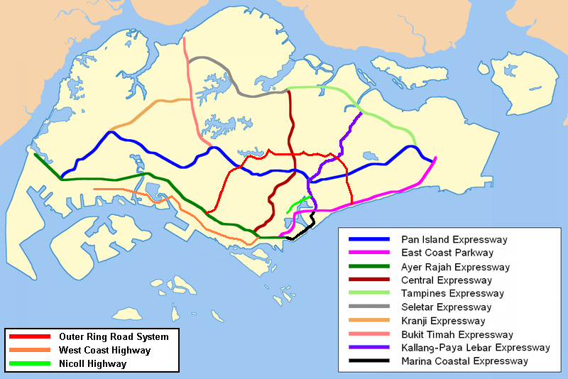
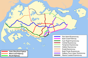 The Outer Ring Road System is coloured red in this map.
The Outer Ring Road System, or more commonly known as ORRS, is a network of major arterial roads in Singapore that forms a 'ring' along the towns outside the city. The ORRS is a semi-expressway, just like the West Coast Highway. Since 1994, roads along the ORRS have been upgraded in stages to provide a smoother route to travel across the island. Construction currently in progress includes Paya Lebar Viaduct and MacRitchie Viaduct.
Contents
Benefit
Once the ORRS is completed, traffic volume on city-bound roads will be reduced. It also provides an alternative route for motorists to travel between the east and west of Singapore without going through the city. Since ORRS is extensively linked to expressways and other arterial roads, such as Bukit Timah Road, motorists can get from one traffic route to another easily. It also serve as alternative bypass routes in the East-West corridor for motorists to travel without going through the city centre.
Upgrading project
The first upgrading stage started in 1994. Two junctions along Farrer Road were the first to be upgraded. The upgrading project had to be carried out in stages in order to minimise disruption to traffic. The completion of the Portsdown Flyover, Queensway Flyover and Queensway Underpass marks another milestone in the realisation of the ORRS. The Farrer Road section of the upgrading project is expected to be completed by 2009.
Route
The ORRS starts from Still Road South and it connects with East Coast Parkway. It then goes north to Still Road and Jalan Eunos, where it links with Pan Island Expressway. It then continues to go north to Eunos Link and Hougang Avenue 3. From here, a left turn is made at Hougang Avenue 3 and the route continues west to Bartley Road, Braddell Road and Lornie Road. A connection is made to the Central Expressway during this stretch. The route then continues south to Adam Road, Farrer Road, Queensway and Portsdown Avenue. During this stretch, a connection is made to the Pan Island Expressway. The ORRS ends at Ayer Rajah Expressway, with the connection with Portsdown Avenue.
Interchange along ORRS
Road name Interchange with1 Type Remarks Name of interchange Still Road South East Coast Parkway Trumpet, Parclo Start of ORRS leading westbound; end of ORRS leading eastbound Marine Parade Flyover Marine Parade Road Box - - Still Road East Coast Road Box - - Koon Seng Road & Lorong J Telok Kurau Box - - Joo Chiat Place Box - - Jalan Eunos Changi Road Box Changi Road travels westbound - Sims Avenue & Sims Avenue East Box Sims Avenue & Sims Avenue East travels eastbound only - Eunos Cresent 3-way - - Pan Island Expressway SPUI - Eunos Flyover Eunos Link Bedok Reservoir Road 3-way - - Ubi Avenue 2 & Kaki Bukit Avenue 1 Box - - Hougang Avenue 3 Airport Road Box - - Bartley Road SPUI From Hougang Avenue 3, the ORRS turns left towards Bartley Road and the ORRS continues from there. Paya Lebar Viaduct Bartley Road Upper Paya Lebar Road Box - - Serangoon Avenue 1 3-way - - Braddell Road Upper Serangoon Road 3-Level Diamond To go from Bartley Road to Braddell Road without stopping, one can drive through Bartley Underpass. This interchange is Singapore's first four-tier interchange, with, from highest to lowest, Upper Serangoon Viaduct, Upper Serangoon Road, Bartley Underpass and NEL tunnel. Bartley Underpass, Upper Serangoon Viaduct Central Expressway, Lorong Chuan 3-Level SPUI Braddell Underpass (along Braddell Road) offers a non-stop drive through this interchange, Braddell Flyover (along CTE) Braddell Underpass, Braddell Flyover Lorong 8 Toa Payoh Slip lane Lorong 8 Toa Payoh only allows traffic to travel westbound only. Vehicles are not permitted to leave the ORRS here. - Bishan Street 11 LILO Can only be accessed by traffic travelling eastbound. - Lorong 6 Toa Payoh Trumpet - Toa Payoh North Flyover Bishan Road Semi-directional T Bishan Flyover (along Braddell Road) offers a non-stop drive through this interchange. Bishan Flyover Thomson Road To go from Braddell Road to Lornie Road (passing Marymount Road's flyover and Thomson Road) without stopping, one can drive on MacRitchie Viaduct. Marymount Flyover, MacRitchie Viaduct Lornie Road To go from Lornie Road to Adam Road without stopping, one can drive on Adam Flyover. Adam Flyover Adam Road Pan Island Expressway Parclo - Adam Flyover Dunearn Road 3-Level Diamond Dunearn Road travels east bound only, Farrer Flyover (from Adam Road to Farrer Road), Dunearn Underpass (along Dunearn Road). Farrer Flyover, Dunearn Underpass Farrer Road Bukit Timah Road 3-Level Diamond Bukit Timah Road travels west wards only, Farrer Flyover, Bukit Timah Underpass (along Bukit Timah Road). Farrer Flyover, Bukit Timah Underpass Holland Road 3-Level Diamond To go from Farrer Road to Queensway without stopping, one can drive through Farrer Underpass, Holland Flyover (along Holland Road) Farrer Underpass, Holland Flyover Queensway Commonwealth Drive LILO Can only be accessed by traffic travelling eastbound. - Margaret Drive LILO Can only be accessed by traffic travelling westbound. - Commonwealth Avenue SPUI Queensway Underpass (along Queensway) offers a non-stop drive through this interchange. Queensway Underpass Portsdown Avenue Queensway 3-way From Queensway, it goes straight towards Portsdown Avenue and the ORRS continues from there. Queensway Flyover Ayer Rajah Expressway SPUI Start of ORRS going eastbound; end of ORRS going westbound Portsdown Flyover ^Note 1 : Only Expressways, Arterial roads and major roads, such as Pan Island Expressway, Bartley Road and Lorong 6 Toa Payoh, will be mentioned. Minor roads, such as Mount Vernon Road, will not be mentioned.
See also
References
- Outer Ring Road System (ORRS)
- Opening Of Extension Of Queensway To The AYE And Queensway/Commonwealth Avenue Interchange
- Speech by Mrs Lim Hwee Hua, Minister of State for Transport and Finance, at the opening of the extension of Queensway to Ayer Rajah Expressway and Queensway Underpass on Saturday, 13 August 2005, 9.15 am
- Braddell Road/Thomson Road/Lornie Road Flyover to open in July
Expressways and semi-expressways of Singapore Expressways Ayer Rajah Expressway · Bukit Timah Expressway · Central Expressway · East Coast Parkway · Kallang–Paya Lebar Expressway · Kranji Expressway · Marina Coastal Expressway (U/C) · North–South Expressway (planned) · Pan Island Expressway · Seletar Expressway · Tampines Expressway
Semi-expressways Major roads in Singapore Alexandra Road · Ang Mo Kio Avenue 6 · Balestier Road · Bartley Road · Beach Road · Boundary Road · Bras Basah Road · Bukit Batok Road · Bukit Panjang Road · Bukit Timah Road · Changi Road · Choa Chu Kang Road · Clementi Road · Commonwealth Avenue · Dunearn Road · East Coast Road · Eu Tong Sen Street · Geylang Road · Holland Road · Jalan Ahmad Ibrahim · Jalan Besar · Jalan Boon Lay · Jalan Bukit Merah · Jalan Kayu · Jurong Island Highway · Jurong Road · Jurong West Avenue 2 · Kallang Bahru · Kallang Road · Kallang Way · Lentor Avenue · Lim Chu Kang Road · Lorong Chuan · Loyang Avenue · Mandai Road · Marine Parade Road · New Bridge Road · New Upper Changi Road · Nicoll Highway · North Bridge Road · Orchard Road · Outer Ring Road System · Pasir Panjang Road · Pasir Ris Drive 3 · Paya Lebar Road · Punggol Road · Queensway · River Valley Road · Robinson Road · Scotts Road · Sembawang Road · Serangoon Road · Shenton Way · Simei Avenue · Sims Avenue · South Bridge Road · Sungei Road · Tampines Avenue 5 · Tampines Road · Telok Blangah Road · Thomson Road · Upper Changi Road East · Victoria Street · West Coast Road · West Coast Highway · Woodlands Road · Woodlands Avenue 3 · Yishun Avenue 2 · Yio Chu Kang Road
 Categories:
- Roads in Singapore
- Bedok
- Paya Lebar
- Serangoon
- Toa Payoh
- Bishan
- Orbital roads
Wikimedia Foundation. 2010.