- Carroll, Iowa
-
Carroll, Iowa — City — Location of Carroll, Iowa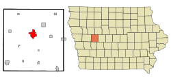
Coordinates: 42°4′10″N 94°51′59″W / 42.06944°N 94.86639°WCoordinates: 42°4′10″N 94°51′59″W / 42.06944°N 94.86639°W Country  United States
State  Iowa
IowaCounty Carroll Area – Total 5.5 sq mi (14.4 km2) – Land 5.5 sq mi (14.4 km2) – Water 0.0 sq mi (0.0 km2) Elevation 1,270 ft (387 m) Population (2010)[1] – Total 10,103 – Density 1,836.9/sq mi (709.2/km2) Time zone Central (CST) (UTC-6) – Summer (DST) CDT (UTC-5) ZIP code 51401 Area code(s) 712 FIPS code 19-11080 GNIS feature ID 0455182 Website City pf Caroll Carroll is a city in and the county seat of Carroll County, Iowa, United States,[2] located along the Middle Raccoon River. The population was 10,103 in the 2010 census, a decline of 3 people from the 10,106 population in the 2000 census.[1][3]
Contents
History
Carroll County is named in honor of Charles Carroll of Carrollton, Maryland. He was the only Roman Catholic to sign the Declaration of Independence, and the longest living signatory.[citation needed]
In 1855 a county government was set up in the town of Carrollton. Three years later a courthouse was constructed at a cost of approximately $3,000. Construction was begun by Nelson Moore, but he died with only one floor completed. The second story was completed by L. J. Hampton.[4]
In 1869 the centrally located railroad town of Carroll City was selected as the county seat, replacing, with some protest, Carrollton. The Chicago and Northwestern Railroad laid out the town and built its first building, a warehouse. Later a $4,000 courthouse was constructed on the town square. This building was used until it burned to the ground in 1886. The vaults and records were undamaged, however, and moved to temporary housing in the Joyce Building and Drees' Music Hall.
The following winter a $40,000 bond issue was approved toward the construction of a new, permanent courthouse. The impressive building was built on the northwest corner of the square (the parking lot of the current courthouse). The stone and brick building, complete with a clock tower, was used for more than three-quarters of a century. It was replaced by a modern-looking building in 1965.
A $750,000 bond issue was used to construct and equip the new courthouse. This building was officially dedicated on September 24, 1966. The highlight of the dedication ceremony was the opening of the boxes sealed in the cornerstone of the old courthouse. The bell from the previous courthouse clock tower sits on the courthouse grounds. Source: Marie Hackett, Curator of the Carroll County Historical Museum, 1991
Geography
Carroll is located at 42°4′10″N 94°51′59″W / 42.06944°N 94.86639°W (42.069544, -94.866361)[5].
According to the United States Census Bureau, the city has a total area of 5.5 square miles (14 km2), all of it land.
Demographics
Carroll
Population HistoryCensus Pop. %± 1870 384 — 1880 1,385 260.7% 1890 2,448 76.8% 1900 2,882 17.7% 1910 3,546 23.0% 1920 4,254 20.0% 1930 4,691 10.3% 1940 5,389 14.9% 1950 6,231 15.6% 1960 7,682 23.3% 1970 8,716 13.5% 1980 9,705 11.3% 1990 9,579 −1.3% 2000 10,106 5.5% 2010 10,103 0% Iowa Data Center [3] 2010 census
The 2010 census recorded a population of 10,103 in the city, with a population density of 1,837/sq mi (709/km2). There were 4,698 housing units, of which 4,357 were occupied.[1]
The racial makeup of the city in the 2010 census was 96.0% White American, 0.6% African American, 0.1% Native Americans in the United States, 0.7% Asian American, 0.0% Native Hawaiians or Pacific Islander American, 1.5% other races and 1.3% were from two or more races. Of those 2.4% were Hispanic and Latino Americans.[6]
2000 census
As of the census[7] of 2000, there were 10,106 people, 4,173 households, and 2,649 families residing in the city. The population density was 1,823.2 people per square mile (704.3/km²). There were 4,431 housing units at an average density of 799.4 per square mile (308.8/km²). The racial makeup of the city was 98.57% White, 0.18% African American, 0.10% Native American, 0.51% Asian, 0.28% from other races, and 0.37% from two or more races. Hispanic or Latino of any race were 0.57% of the population.
There were 4,173 households out of which 31.8% had children under the age of 18 living with them, 51.7% were married couples living together, 8.9% had a female householder with no husband present, and 36.5% were non-families. 31.9% of all households were made up of individuals and 16.2% had someone living alone who was 65 years of age or older. The average household size was 2.36 and the average family size was 2.99.
Population spread: 25.9% under the age of 18, 8.0% from 18 to 24, 26.0% from 25 to 44, 20.4% from 45 to 64, and 19.7% who were 65 years of age or older. The median age was 39 years. For every 100 females there were 89.5 males. For every 100 females age 18 and over, there were 85.1 males.
The median income for a household in the city was $39,854, and the median income for a family was $51,020. Males had a median income of $31,124 versus $22,215 for females. The per capita income for the city was $20,442. About 3.4% of families and 5.2% of the population were below the poverty line, including 3.8% of those under age 18 and 7.4% of those age 65 or over.
Notable people
- Lance Cade, Professional Wrestler
- Adam Haluska, professional basketball player
- Ken Henderson (born 1946) Major League Baseball player from 1965–1980
- Mary Lundby (1948–2009) Former Iowa State Senator District 18
- Nick Nurse, basketball coach for the Iowa Energy
- Everett Rogers communication scholar
- Joe Slade White, Democratic media consultant
References
- ^ a b c "Population & Housing Occupancy Status 2010". United States Census Bureau American FactFinder. http://factfinder2.census.gov/faces/tableservices/jsf/pages/productview.xhtml?pid=DEC_10_PL_GCTPL2.ST13&prodType=table. Retrieved 2011-08-06.
- ^ "Find a County". National Association of Counties. http://www.naco.org/Counties/Pages/FindACounty.aspx. Retrieved 2011-06-07.
- ^ a b "Data from the 2010 Census". State Data Center of Iowa. http://www.iowadatacenter.org/archive/2011/02/feb10. Retrieved 2011-08-06.
- ^ http://www.co.carroll.ia.us/history.htm
- ^ "US Gazetteer files: 2010, 2000, and 1990". United States Census Bureau. 2011-02-12. http://www.census.gov/geo/www/gazetteer/gazette.html. Retrieved 2011-04-23.
- ^ "Race and Hispanic or Latino Origin in Iowa's Incorporated Places: 2010". State Data Center of Iowa. http://www.iowadatacenter.org/archive/2011/02/cityrace.pdf. Retrieved 2011-08-06.
- ^ "American FactFinder". United States Census Bureau. http://factfinder.census.gov. Retrieved 2008-01-31.
External links
- Official Carroll Web Site
- Carroll Chamber of Commerce
- City Data Detailed Statistical Data and more about Carroll, Iowa
Municipalities and communities of Carroll County, Iowa Cities 
Townships Footnotes ‡This populated place also has portions in an adjacent county or counties
Categories:- Populated places in Carroll County, Iowa
- Cities in Iowa
- County seats in Iowa

Wikimedia Foundation. 2010.