- Mangaroa Railway Station
-
Mangaroa
New Zealand Government Railways (NZGR)
regional rail
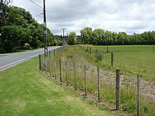
The sole remnant of the station, its loading bank.Station statistics Address Flux Road, Mangaroa. Coordinates 41°7′16.58″S 175°6′37.48″E / 41.1212722°S 175.1104111°E Lines Wairarapa Line Platforms Single Other information Opened 1 January 1878 Closed 30 October 1955 Owned by Railways Department Formerly Mungaroa  Looking north-east of the station, to the foothills where the line started its climb to Kaitoke.
Mangaroa railway station was a single-platform rural railway station on the Wairarapa Line between Upper Hutt and Featherston in the Wellington region of New Zealand’s North Island, on the section that was replaced by the Rimutaka Deviation in 1955. It served the small rural settlement of Mangaroa, in the Mangaroa Valley, east of Upper Hutt.
Contents
History
Mangaroa station was not originally built prior to the opening of Kaitoke station as part of the Mungaroa Contract.
 Looking south-west of the station, at the site of the Flux Road level crossing and in the direction of the Mangaroa River.
In 1876–1877, a privately-owned 43-wagon capacity siding was laid several chains to the north of Cruickshanks Tunnel to serve a timber mill that was owned, constructed and operated by James Cruickshanks, a member of the Wellington Provincial Council. His siding handled only timber traffic, but also became a stopping place for main line trains, and was known as Cruickshanks. He later built a second mill about half a mile closer to Mangaroa station, but the first remained in use until 1889 when the siding was lifted. The second mill operated its own tramway between the mill and station yard where timber was transferred to railway wagons.
During the construction of the Rimutaka Tunnel, a siding was laid from the eastern end of the Mangaroa Valley and several chains north-east of Mangaroa station to the new Maymorn Station yard. This was to enable work trains to bring lengths of welded rail, other supplies and equipment from the Hutt Workshops directly to the construction site. Once the tunnel and deviation opened, this siding, along with the rest of the old section, was lifted in 1956.
A military siding was established at Mangaroa in World War II to service RNZAF No. 2 Stores Depot that was later used by the Army. The depot opened in 1942 after being moved from the RNZAF station at Rongotai and was used until after the war. After the war the depot was a disposal site for surplus stores until RNZAF use ceased in July 1949, at which time it is assumed that the site was transferred to the NZ Army for their use.
Proposals
Prior to the construction of the Rimutaka Tunnel, several proposals for a tunnel under the Rimutaka Ranges to bypass the Incline section involved tunnels with a western portal to the north-east of Mangaroa station.
In 1898 a survey was completed for a 5-mile (8.0 km) tunnel between Mangaroa and Cross Creek. The idea received a great deal of attention, but ultimately went nowhere as such a tunnel could not be contemplated at the time.
In 1921–1922, a feasibility study was conducted which again considered the possibility of a Mangaroa to Cross Creek tunnel. This would involve an improved gradient from Upper Hutt, followed by a 5-mile-18-chain (8.4 km) tunnel on a maximum gradient of 1 in 132. Again, the Public Works Department did no further work on the idea.
In 1936 the Government announced its intention to proceed with a Mangaroa to Cross Creek tunnel. Though new surveys were conducted in 1938–1939, the project was delayed once more, this time by war conditions. After the war when work restarted on a tunnel through the Rimutaka Ranges, it followed an alignment that bypassed Mangaroa altogether.
Today
Very little of the old railway formation remains between the west and east sides of the Mangaroa Valley. Cruickshanks Tunnel still exists, though there is no formal access to it and the status of public access is uncertain. The only remains of the old Mangaroa River bridge are a few wooden bridge piles. There is still a noticeable hump in Flux Road just before the T-intersection with Leonards Road, the site of a level crossing just before the station.
Of the station itself only the loading bank remains, at the side of Flux Road.
See also
References
- Cameron, Walter Norman (1976). A Line Of Railway: The Railway Conquest of the Rimutakas. Wellington: New Zealand Railway and Locomotive Society. ISBN 0-908573-00-6.
- Quail Map Company (1993). New Zealand Railway and Tramway Atlas (4th edition ed.). England: The Quail Map Company. ISBN 0-900609-92-3.
- Ross, J. M. S.. Royal New Zealand Air Force. Historical Publications Branch. http://www.nzetc.org/tm/scholarly/tei-WH2AirF-c20-3.html#n317.
External links
- Rimutaka Incline Railway. Newsletter #8, Connection to heritage route at Maymorn for a plan view and brief description of the siding that linked the old and new lines during the construction of the Rimutaka Tunnel.
- Cruickshanks Tunnel.
Stations on the Wairarapa Line Original route Te Aro • Lambton • Kaiwarra • Ngahauranga • Petone • Lower Hutt • Melling • Belmont • Andrews • Pitcaithly's • Haywards • Silverstream Bridge • Silverstream • Heretaunga • Trentham • Wallaceville • Upper Hutt • Mangaroa • Kaitoke • Summit • Cross Creek • Pigeon Bush • Featherston • Fernside • Woodside Junction • Matarawa • Dalefield • Carterton • Clareville • Middleton • Waingawa • Solway • Renall Street • Masterton • Opaki • Kopuaranga • Mauriceville • Mangamahoe • Eketahuna • Newman • Hukanui • Mangamaire • Konini • Pahiatua • Mangatainoka • Ngawapurua • WoodvilleCurrent route Wellington • Kaiwharawhara • Ngauranga • Petone • Ava • Woburn • Waterloo • Epuni • Naenae • Wingate • Taita • Pomare • Manor Park • Silverstream • Heretaunga • Trentham • Wallaceville • Upper Hutt • Maymorn • Featherston • Fernside • Woodside • Matarawa • Dalefield • Carterton • Clareville • Middleton • Waingawa • Solway • Renall Street • Masterton • Opaki • Kopuaranga • Mauriceville • Mangamahoe • Eketahuna • Newman • Hukanui • Mangamaire • Konini • Pahiatua • Mangatainoka • Ngawapurua • WoodvilleBold indicates stations at which the Wairarapa Connection stops • Italics indicates stations that have closed to passengers Categories:- Rail transport in Wellington
- Defunct railway stations in New Zealand
- Railway stations opened in 1878
- Railway stations closed in 1955
- Buildings and structures in Upper Hutt


Wikimedia Foundation. 2010.