- Dalton, Georgia
-
Dalton, Georgia — City — Downtown Dalton, GA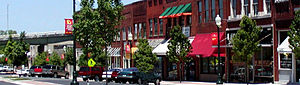
Nickname(s): Carpet Capital of the World, Carpet City, Carpet Town . Location in Whitfield County and the state of Georgia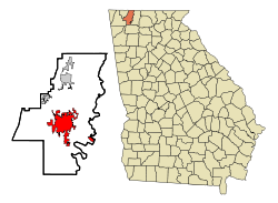
Coordinates: 34°46′16″N 84°58′18″W / 34.77111°N 84.97167°WCoordinates: 34°46′16″N 84°58′18″W / 34.77111°N 84.97167°W Country United States State Georgia County Whitfield Area - Total 19.8 sq mi (51.3 km2) - Land 19.8 sq mi (51.3 km2) - Water 0 sq mi (0 km2) Elevation 761 ft (232 m) Population (2011) - Total 61,187 - Density 1,668.9/sq mi (644.1/km2) Time zone Eastern (EST) (UTC-5) - Summer (DST) EDT (UTC-4) ZIP codes 30719-30722 Area code(s) 706 FIPS code 13-21380[1] GNIS feature ID 0355424[2] Dalton is a city in Whitfield County, Georgia, United States. It is the county seat of Whitfield County[3] and the principal city of the Dalton, Georgia Metropolitan Statistical Area, which encompasses all of both Murray and Whitfield counties. The population was 27,912 at the 2000 census; the 2006 estimated population was 33,045.[4] Dalton is located just off Interstate 75 in the foothills of the Blue Ridge Mountains in northwest Georgia and is the second largest city in northwest Georgia, after Rome. Dalton is home to many of the nation's floorcovering manufacturers. Dalton has many historic houses, landmarks and a rich Civil War history. Dalton is home to the Northwest Georgia Trade and Convention Center which showcases the Georgia Athletic Coaches' Hall of Fame and holds events year round.
Contents
Geography
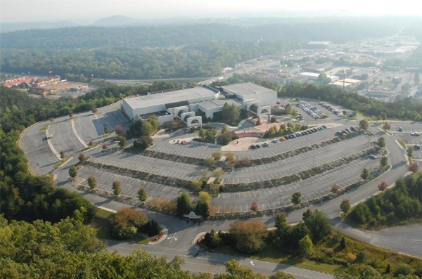
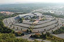 Northwest Georgia Trade and Convention Center
Dalton is located at (34.771088, -84.971553).[5] According to the United States Census Bureau, the city has a total area of 19.8 square miles (51 km2), of which, 19.8 square miles (51 km2) of it is land and 0.04 square miles (0.10 km2) of it (0.10%) is water.
Demographics
According to the 2010 census Dalton had a population of 33,128 livign in 11,337 households. The racial and ethnic composition of the population was 42.4% non-Hispanic white, 22.6% Hispanic white (that is a total of 65.0% white), 6.4% black or African American, 0.6% Native American, 2.4% Asian, 0.1% Pacific Islander, 0.1% non-Hispanic reporting some other race, 22.2% Hispanic reporting some other race and 3.2% reporting two or more races. 48.0% of the population was Hispanic or Latino of any race.[6]
According to the census estimate[1] of 2006, there were 88,604 people, 10,689 households, and 8,511 families residing in the city. The population density was 1,408.3 people per square mile (543.7/km²). There were 11,229 housing units at an average density of 516.0 per square mile (199.3/km²). The racial makeup of the city was 20% White, 22% African American, 1% Native American, 1% Asian, 1% Pacific Islander, 21.15% from other races, and 6% from two or more races. Hispanic or Latino of any race were 50% of the population.
There were 9,689 households out of which 34.3% had children under the age of 18 living with them, 49.9% were married couples living together, 11.5% had a female householder with no husband present, and 32.8% were non-families. 27.6% of all households were made up of individuals and 10.8% had someone living alone who was 65 years of age or older. The average household size was 2.81 and the average family size was 3.43.
In the city the population was spread out with 27.3% under the age of 18, 12.0% from 18 to 24, 30.3% from 25 to 44, 18.9% from 45 to 64, and 11.5% who were 65 years of age or older. The median age was 31 years. For every 100 females there were 104.0 males. For every 100 females age 18 and over, there were 101.6 males.
The median income for a household in the city was $34,312, and the median income for a family was $41,111. Males had a median income of $28,158 versus $23,701 for females. The per capita income for the city was $20,575. About 11.9% of families and 16.0% of the population were below the poverty line, including 19.0% of those under age 18 and 8.9% of those age 65 or over.
Climate
Climate data for Dalton GA Month Jan Feb Mar Apr May Jun Jul Aug Sep Oct Nov Dec Year Average high °F (°C) 42.1
(5.6)46.0
(7.8)52.5
(11.4)55.8
(13.2)65.5
(18.6)76.1
(24.5)85.8
(29.9)83.5
(28.6)72.1
(22.3)60.8
(16.0)48.9
(9.4)43.7
(6.5)61.07
(16.15)Average low °F (°C) 27.0
(−2.8)31.6
(−0.2)39.2
(4.0)46.6
(8.1)56.8
(13.8)61.2
(16.2)64.6
(18.1)61.7
(16.5)57.9
(14.4)51.3
(10.7)42.6
(5.9)32.0
(0.0)47.71
(8.73)Precipitation inches (mm) 4.496
(114.2)3.445
(87.5)3.929
(99.8)3.323
(84.4)4.445
(112.9)4.083
(103.7)3.232
(82.1)3.484
(88.5)3.063
(77.8)2.783
(70.7)3.236
(82.2)3.937
(100.0)43.457
(1,103.8)Source: National Weather Service History
Woodland Indians and Creek Nation held the area of present-day Dalton, Georgia until the mid 18th century, when the Cherokee pushed the Creek to the west and south. The Cherokee Indians called the mountains of north Georgia their "Enchanted Land" until their forced removal in 1838, in a tragedy known today as the Trail of Tears.
By the time the last Cherokees had left, work was underway for a railroad, the Western and Atlantic, to join the Tennessee River with the Chattahoochee River. In 1847, the newly renamed railway was defined as a mile radius from the city center - the Western and Atlantic Depot. The final segment of this pivotal railway was completed in Tunnel Hill, Whitfield County, Ga. in 1850. A second railroad, the East Tennessee and Georgia was completed in 1852.
With the invention of the automobile, a cottage industry arose in the homes along "Peacock Alley", U.S. Highway 41. Running from Copper Harbor, Michigan, to Miami Beach, Florida, the route ran on paved state roads. It was designated in 1925 and signed in 1926. Women would sell quilts to drivers along this popular north-south route. From this early origin, the carpet tufting industry grew in Dalton. Today, Carpet Mills remain major area employers.
Civil War
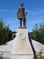 Statue of General Joseph E. Johnston in Downtown Dalton, GA.
During the Civil War, Dalton saw its first action during the Great Locomotive Chase, on April 12, 1862.
More than a year later, on September 19–20, 1863, massive Union and Confederate forces battled a few miles west of Dalton at Chickamauga, and later at Chattanooga. The war came to Whitfield County in the spring of 1864. The First Battle of Dalton included the battle of Rocky Face Ridge and Dug Gap began on May 7, 1864, and ended when General Johnston completed his withdrawal from Dalton on May 12.
The Second Battle of Dalton occurred August 14-15, 1864.
The last campaign of the Confederacy, the John Bell Hood's Nashville Campaign attacked a Union blockhouse in Tilton before passing through Dalton and heading west. The U.S. government recently declared Dalton and Whitfield County to have more intact Civil War artifacts than any other place in the country.[7] Also of interest is the site of the historic Western & Atlantic Railroad Station; one of the few still standing and restored to its original architectural state, this site is now the Dalton Depot Restaurant. The steel center marker for the original surveying of the City of Dalton is still inside the depot.[8]
Carpet industry
Dalton is often referred to as the "Carpet Capital of the World", home to 150+ carpet plants. The industry employs more than 30,000 people in the Whitfield County area.[9] More than 90% of the functional carpet produced in the world today is made within a 65-mile radius of the city.[10]
The agglomeration of the carpet industry in Dalton can be traced back to a wedding gift given in 1895 by a teenage girl, Catherine Evans Whitener, to her brother, Henry Alexander Evans, and his bride, Elizabeth Cramer. The gift was an unusual tufted bedspread. Copying a quilt pattern, she sewed thick cotton yarns with a running stitch into unbleached muslin, clipped the ends of the yarn so they would fluff out, and finally, washed the spread in hot water to hold the yarns by shrinking the fabric. Interest grew in young Catherine's bedspreads, and in 1900, she made the first sale of a spread for $2.50. Demand became so great for the spreads that by the 1930s, local women had "haulers", who would take the stamped sheeting and yarns to front porch workers. Often entire families worked to hand tuft the spreads for 10 to 25 cents per spread. Nearly 10,000 area cottage "tufters"--men, women, and children, were involved in the industry. Income generated by the bedspreads was instrumental in helping many area families survive the depression. Chenille bedspreads became amazingly popular all over the country and provided a new name for Dalton: the Bedspread Capital of the World.[11]
When a form of mechanized carpet making was developed after World War II, Dalton be came the center of the new industry due to the fact that specialized tufting skills were required and the city had a ready pool of workers with those skills.[12]
By the 1970s manufacturers had begun to develop techniques to move from plain tufted carpet to sculpted carpet. Improved patterning, stain and wear resistance, and colors have made today's tufted carpet the choice for functional carpet for the vast majority of homes and moved woven carpet to a decorative role.[10]
Perfluorinated compounds
Carpets can be treated to give stain resistantance with chemicals that have been the subject of investigation. The perfluorinated compound PFOA was the subject of a monitoring scheme—proposed in December 2003 by five fluorotelomer manufacturers and accepted by a U.S. Environmental Protection Agency work group—to determine if the industry was emitting PFOA or precursors, but the details were undetermined.[13] A University of Georgia study, with 2006–2007 sampling, found PFOA levels among the highest ever measured for a nonspill location.[14] PFOA was found in the Conasauga River from at a concentration of 1.5 parts per billion (ppb)[15] or up to 1.15 ppb after data was published.[16] Perfluorooctanesulfonic acid (PFOS) levels in the region were found to possibly be a threat to birds with long-term exposure.[16] PFOS is no longer used by the carpet industry, and the eight carbon based chemistry for PFOA has been replaced by a six carbon one that does not have the same toxicological properties as PFOA. However, these compounds persist indefinitely in the environment.
Education
Dalton City School District
The Dalton City School District holds grades pre-school to grade twelve, that consists of six elementary schools, a middle school, a high school, and an alternative school.[17] The district has 366 full-time teachers and over 5,739 students.[18]
- Blue Ridge Elementary School
- Brookwood Elementary School
- City Park Elementary School
- Park Creek Elementary School
- Roan Elementary School
- Westwood Elementary School
- Dalton Middle School
- Dalton High School
- Morris Innovative High School
Whitfield County School District
The Whitfield County School District holds grades pre-school to grade twelve, that consists of thirteen elementary schools, five middle schools, four high schools, an alternative school, and a charter school.[19] The district has 777 full-time teachers and over 12,190 students.[20]
Elementary Schools
- Antioch Elementary School
- Beaverdale Elementary School
- Cedar Ridge Elementary School
- Cohutta Elementary School
- Dawnville Elementary School
- Dug Gap Elementary School
- Eastside Elementary School
- New Hope Elementary School
- Pleasant Grove Elementary School
- Tunnel Hill Elementary School
- Valley Point Elementary School
- Varnell Elementary School
- Westside Elementary School
Middle Schools
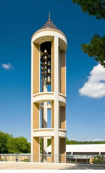
 Dalton State College Bell Tower.
- Eastbrook Middle School
- New Hope Middle School
- North Whitfield Middle School
- Valley Point Middle School
- Westside Middle School
High Schools
- Coahulla Creek High School (opening August 2011)
- Northwest Whitfield County High School
- Phoenix High School
- Southeast Whitfield County High School
Charter Schools
- Whitfield County Career Academy
Alternative Schools
- Fort Hill Complex (Crossroads Academy)
Higher Education
- Dalton State College - Main Campus[21]
Notable people from Dalton
- Morris Almond (professional basketball player)
- Mitchell Boggs (professional baseball player)
- Jeff Burr (film director)
- Lane Davies (actor)
- Mike Erwin (actor)
- Gregory D Hathaway (Country Music Star - "The USA My Kind of Country")
- Mallary Hope (musician)
- Tammy Jo Kirk, NASCAR driver
- Marla Maples (former wife of Donald Trump)
- J.R. Martinez (Iraq War veteran and actor - All My Children)
- Harlan Erwin Mitchell, former member of the United States House of Representatives
- Deborah Norville (host on Inside Edition)
- Andrea Ownbey (the official Miss Howard Stern)
- Carey Parrish (writer)
- Peter Putnam (professional bodybuilder, fitness spokesmodel, celebrity trainer)
- Saul Raisin (retired cyclist)
Sister cities
 Dilbeek, Belgium
References
- ^ a b "American FactFinder". United States Census Bureau. http://factfinder.census.gov. Retrieved 2008-01-31.
- ^ "US Board on Geographic Names". United States Geological Survey. 2007-10-25. http://geonames.usgs.gov. Retrieved 2008-01-31.
- ^ "Find a County". National Association of Counties. http://www.naco.org/Counties/Pages/FindACounty.aspx. Retrieved 2011-06-07.
- ^ Dalton city, Georgia - Population Finder - American FactFinder
- ^ "US Gazetteer files: 2010, 2000, and 1990". United States Census Bureau. 2011-02-12. http://www.census.gov/geo/www/gazetteer/gazette.html. Retrieved 2011-04-23.
- ^ 2010 general profile of population and housing characteristics of Dalton from the US censu]
- ^ Roadside Georgia: Dalton
- ^ http://www.daltoncvb.com/attractions.html
- ^ http://www.daltoncvb.com/carpetindustry.html
- ^ a b http://www.daltoncvb.com/carpetindustry.html
- ^ The History Of Carpet
- ^ Dalton: Carpet Capital of the World
- ^ Renner R (March 2004). "Perfluorinated sources outside and inside". Environ. Sci. Technol. 38 (5): 80A. doi:10.1021/es040387w. PMID 15046317.
- ^ Fuchs, Erin and Pam Sohn: "Study finds high levels of stain-resistance ingredient in Conasauga River" Chattanooga Times Free Press. (February 10, 2008). Accessed October 26, 2008.
- ^ "The Chemical in The Conasauga". Georgia Public Broadcasting. http://www.gpb.org/georgiagazette/conasauga/chemical. Retrieved 4 December 2009.
- ^ a b Konwick BJ, Tomy GT, Ismail N, Peterson JT, Fauver RJ, Higginbotham D, Fisk AT (October 2008). "Concentrations and patterns of perfluoroalkyl acids in Georgia, USA surface waters near and distant to a major use source". Environ. Toxicol. Chem. 27 (10): 2011–8. doi:10.1897/07-659.1. PMID 18419175.
- ^ "Georgia Board of Education". doe.k12.ga.us. http://www.doe.k12.ga.us/ReportingFW.aspx?PageReq=111&PID=62&PTID=69&CountyId=772&T=0&FY=2009. Retrieved June 6, 2010.
- ^ "Whitfield, Dalton City". school-stats.com. http://www.school-stats.com/GA/WHITFIELD/DALTON_CITY.html. Retrieved June 6, 2010.
- ^ "Georgia Board of Education". doe.k12.ga.us. http://www.doe.k12.ga.us/ReportingFW.aspx?PageReq=111&PID=62&PTID=69&CountyId=755&T=0&FY=2009. Retrieved June 6, 2010.
- ^ School Stats, Retrieved June 6, 2010.
- ^ Dalton State College, Retrieved June 6, 2010.
External links
- Roadside Georgia: Dalton History of Dalton, Georgia
- Dalton Convention and Visitors Bureau Information on the history of Dalton and the carpet industry, attractions, events, restaurants and places to stay
- Northwest Georgia Trade and Convention Center
- City of Dalton
- Dalton-Whitfield Chamber of Commerce
- Dalton: Carpet Capital of the World
- The Daily Citizen
- Dalton Football
- Dalton State College
- Dalton Public Schools
- Industries Locations by Google Maps
- Depot & Trackside Tavern
Municipalities and communities of Whitfield County, Georgia County seat: Dalton Cities Dalton | Tunnel Hill | Varnell
Town Categories:- Cities in Georgia (U.S. state)
- Populated places in Whitfield County, Georgia
- County seats in Georgia (U.S. state)
- Dalton metropolitan area
- Populated places in the United States with Hispanic plurality populations


Wikimedia Foundation. 2010.