- Brown Clee Hill
-
Brown Clee Hill 
Brown Clee Hill, looking towards Abdon BurfElevation 540 m (1,772 ft) Prominence 373 m (1,224 ft) Parent peak Plynlimon Listing Marilyn, County Top Location Location Shropshire, England Topo map OS Landranger 138 OS grid SO593865 Brown Clee Hill is the highest hill in the rural English county of Shropshire, at 540 metres above sea level. It is one of the Clee Hills, and is in the Shropshire Hills Area of Outstanding Natural Beauty.
Contents
Geography
Brown Clee Hill lies five miles north of its sister and neighbour, Titterstone Clee Hill. The highest peak of the hill is Abdon Burf, at 540 metres high with Clee Burf at 510m.
Much more of Brown Clee Hill is private land than on Titterstone Clee, and large areas are covered with coniferous plantations. The eastern expanse of the hill is in possession of the Burwarton Estate under ownership of Viscount Boyne, whilst the western fringes of the hill are owned by various private land owners and the parish of Clee St. Margaret.
The common land features the remains of where an Iron Age hill fort once stood (See Below).
Nearby towns are Ludlow, Cleobury Mortimer, Church Stretton, Broseley, Bridgnorth and Much Wenlock.[1]
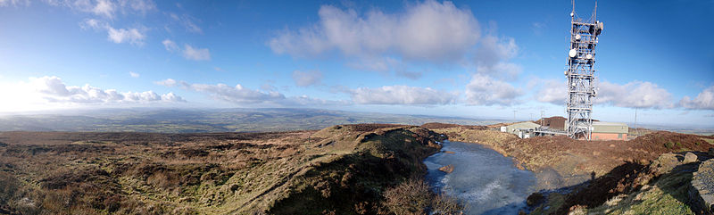
Several air traffic control radar masts on the summit of the hill can be seen for many miles around. They, along with the ones on top of Titterstone Clee Hill build up a picture of all the aircraft in a hundred mile radius.
A toposcope (recently built) points out local landmarks and is sited at the summit.
History
Several hill forts are dotted around the Clee Hills. Nordy Bank is the last intact survivor of three Iron Age hill forts on Brown Clee. The other two, at Abdon Burf and Clee Burf, have been largely lost to quarrying activity. Nordy Bank occupies a sloping ridge top site and its ramparts are up to three metres high. It was built some time in the British Iron Age first Millennium BC and gives a commanding view of the local countryside.
Quarrying was for long the main income of the area, and it was widely known as a dangerous and gruelling job. People would walk to the Abdon Quarry on Brown Clee Hill from as far as Bridgnorth and Ludlow, and often they would tend to at least one other job. They were quarrying for Dhustone (Dolerite), a very hard and challenging material to extract.
The Abdon Clee quarries closed in 1936, and by this time the area had become almost industrial, with a concrete plant, tarmac plant in Ditton Priors, plus a small railway to move the stone - and the quarries themselves. If the wind was coming down over the hill it was apparently possible to hear the stone crusher at the top crunching away, even down in Cleehill village.
After the quarries closed, a lot of the quarrymen went to work at the Cockshutford quarries on the other side of Brown Clee. But the dhustone there wasn't as good quality and durable as over on the Abdon side and that quarry failed to after a short period. Many of the men returned and worked at the naval ammunition depot set up at Ditton Priors at the start of the war. The quarries totally finished in the 1930s and 40s.
Whilst the radar facilities of the Clee Hills protect aircraft, both hills were once a hazard to aircraft, and a memorial commemorates the 23 Allied and German airmen killed here when their planes crashed into Brown Clee during World War II. The first aircraft to crash into Brown Clee was a German Junkers 88, on 1 April 1941. Two Wellington Bombers, a Hawker Typhoon and at least two Avro Ansons also crashed here. It is now thought that there were more wartime crashes on Brown Clee than any other hill in Britain. The engine and other parts of one of the Wellington Bombers are said to rest on the bottom of Boyne Water, Brown Clee.
Views
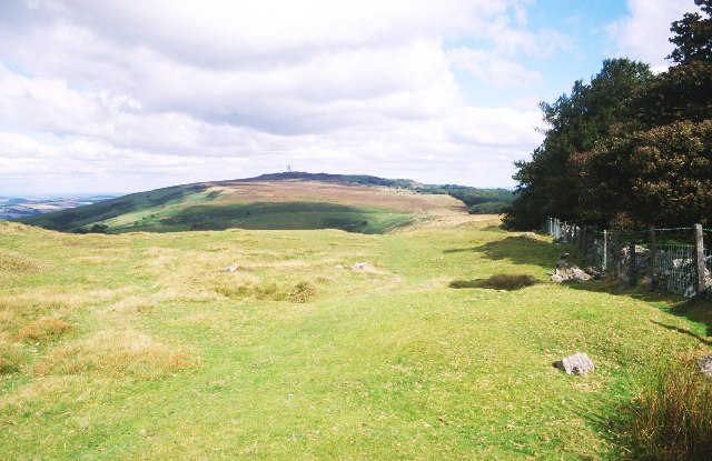
 View to the west from Abdon Burf
See also
- List of places in Shropshire
- List of hill forts in England
- List of hill forts in Scotland
- List of hill forts in Wales
References
External links
- BBC Shropshire Clee Hills photo gallery
- Geology of Shropshire - Brown Clee
- Brown Clee Hill Computer Generated Summit Panorama
Coordinates: 52°28′30″N 2°36′02″W / 52.47490°N 2.60063°W
Ceremonial county of Shropshire Boroughs or districts Major settlements Rivers Topics - Geology
- Settlements
- History
- Museums
- Parliamentary constituencies
- Railways
Categories:- Hills of Shropshire
- Marilyns of England
- Extremities of Shropshire
- Iron Age sites in England
- Buildings and structures in Shropshire
- Hill forts in Shropshire
- Archaeological sites in Shropshire

Wikimedia Foundation. 2010.