- Titterstone Clee Hill
-
Titterstone Clee Hill 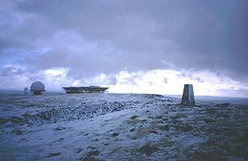
The summit under snow, with radar station beyond.Elevation 533 m (1,749 ft) Prominence 232 m (761 ft) Parent peak Brown Clee Hill Listing Marilyn Location Location Shropshire,  England
Range Shropshire Hills Topo map OS Landrangers 137, 138 OS grid SO591779 Titterstone Clee Hill, sometimes referred to as Clee Hill or Titterstone Clee, is a hill in the rural English county of Shropshire, rising at the summit to 533 m above sea level.
It is in the Clee Hills, in the Shropshire Hills Area of Outstanding Natural Beauty. The nearest town to the hill is Ludlow.
Contents
Geography
Titterstone Clee is the third-highest hill in Shropshire, beaten only by the nearby Brown Clee Hill (540 m) and Stiperstones (536 m). Much of the higher part of the hill is common land, used for the grazing of sheep, air traffic control services and working or disused quarries. The summit of Titterstone Clee is bleak, treeless and shaped by decades of quarrying. Many of the structures still remain, and lend to the ghostly atmosphere of the hill top, especially during the prolonged winter fogs that descend over the hills.
Recent scientific investigation has led to some individuals claiming that Titterstone Clee was once an active volcano. However, there has been no conclusive evidence to confirm these claims.
The weather on Titterstone Clee Hill can be particularly hazardous, with locally infamous fog and drizzle being commonplace. Snow can also cause problems in winter, as well as gales.
Most of the summit of the hill is effectively man-made, the result of years of quarrying dhustone (dolerite) to be used in road-building. Also, many derelict quarry buildings are scattered over the hill, now used only by sheep sheltering from the worst of weather. Combined, these give the summit of the hill an eerie, other worldly feel.
The A4117 between Cleobury Mortimer and Ludlow runs along the southern slope of Titterstone Clee, and rises to 381 metres above sea level at its highest point on Clee Hill Common. Because of this, the road is often affected by snow in winter.
The small village of Cleehill lies on this road as it crosses the hill, and at 395 metres above sea level, it is home to the highest pub in Shropshire, called "The Kremlin".[1]
From the hill it is possible on a clear day to see west to Snowdonia, north east to the Peak District, east to the Black Country, south east to the Cotswolds, south to the Malvern Hills, and south west to the Black Mountains and Brecon Beacons. The hill is said to provide one of the best views in England on a clear day.[citation needed]
History, quarrying and land usage
Over the years Titterstone Clee has been subject to much quarrying for dhustone or dolerite. It is because of this that the hill is littered with many abandoned quarries and mine shafts, one of which has now flooded to form a lake. The largest quarries have sheer drops of up to around thirty meters (one hundred feet).
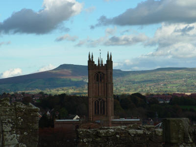
 Titterstone Clee Hill has a towering appearance over Ludlow. Here it is seen from Ludlow Castle.
Before the Second World War, the area would be described as industrial, because of the presence of wide-scale quarrying and associated activity. Men came from places such as Bridgnorth and Ludlow to work in the quarries, and the village of Dhustone on Titterstone Clee was built especially for the quarry workers. Crumbling remains of quarry buildings now litter the hill, reminders of a bygone industry that once employed more than 2,000 people here. An old railway incline is still visible on the hill, and a large concrete structure, under which the wagons were filled with stone, still remains next to the modern day car park. Railway infrastructure remained until the late 1950s.[2] In the past the quarries have also been worked (on a much smaller scale) for coal and limestone.
Early in the 20th century, a second quarry opened on Titterstone Clee Hill and an aerial ropeway was built to carry stone off the hill to the railway at Detton Ford. The footings for the tall pylons which supported the wires still remain near the summit, parallel to the modern day track to the radar domes.
Titterstone Clee is still quarried, but on a much smaller scale than in its heyday, on the lower slopes behind Cleehill village. Quarrying resumed in the late 1980s 50 years after the summit Dhustone quarry closed, and some old workings have been restored. The main buildings of the quarry are just visible from the A4117 road.
Several radar domes and towers operate on the summit of the hill. The radar arrays are part of the National Air Traffic Services (NATS) radar network, and cover one of 30 overlapping regions of UK airspace. The ones on the Clee Hills monitor all aircraft within a 100-mile radius. The domes and masts are well-known local landmarks, with one in particular often being nicknamed "the golf ball" because of it looking like a giant teed-up golf ball. They can be seen for many miles, even from some parts of The Black Country.
A 20th Century triangulation pillar marks the summit, whilst just to the left of it are the remains of a Bronze Age cairn, dating back up to 4,000 years and indicating that the summit was a likely ceremonial site. Although badly damaged by quarrying, Titterstone Clee's Iron Age hill fort has fared better than those on Brown Clee. It is of note that the walls of the fort are made up of stone blocks, instead of earth banks. Also near the summit is the "giant's chair" - a pile of boulders left behind in the ice age.
Titterstone Clee is popular with walkers, but much less so than neighbouring hills such as the Long Mynd. Walkers can access the summit by taking the A4117 from just past Bewdley and Ludlow. About three quarters of a mile to the Ludlow side of Cleehill village, turn right up the single-track road signposted "Dhustone" and "Titterstone Clee summit". Drive to the top of the track and park on the old railway yard near the old quarry buildings. To walk to the summit follow the track around the radar installations.
In fiction
Titterstone Clee plays a central role in the Ellis Peters' novel "The Virgin in the Ice."
External links
- Shropshire Geology - Titterstone Clee
- Computer generated summit panorama from Titterstone Clee
- BBC Shropshire photo gallery
- Simon Denison - Quarry land
Clee Hill is the only hill noted on the Mappa Mundi, a13th? Century map of the world displayed at Heteford Cathederal. The monk who drew the map must have been local to the hill, which is 30 miles from Hereford.
See also
- Clee Hill Junction, the railway junction that was once in this area
References
- ^ BBC Shropshire The Kremlin, Cleehill
- ^ D.J. Norton Railway Photographs
Categories:- Hills of Shropshire
- Marilyns of England
- Industrial railways in England
- 3ft gauge railways

Wikimedia Foundation. 2010.