- Cressage
-
Coordinates: 52°37′59″N 2°36′21″W / 52.63310°N 2.60575°W
Cressage 
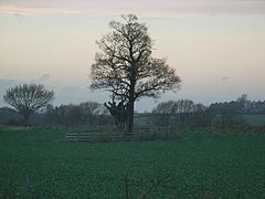
The "Lady Oak" at Cressage
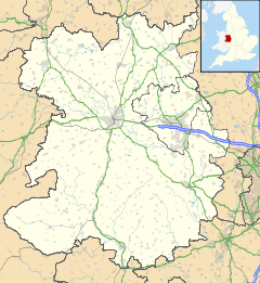
 Cressage shown within Shropshire
Population 783 (2001 Census)[1] Parish Cressage Shire county Shropshire Ceremonial county Shropshire Region West Midlands Country England Sovereign state United Kingdom Police West Mercia Fire Shropshire Ambulance West Midlands EU Parliament West Midlands List of places: UK • England • Shropshire Cressage is a village and civil parish in Shropshire, England. It lies on the junction of the A458 and B4380 roads and the River Severn flows around its northern boundary. The Royal Mail postcode begins SY5.[2] The parish council is combined with the neighbouring parish of Sheinton.
Contents
History
The village was originally called Christesache, or "Christ's Oak", and this over time has been corrupted to form the word "Cressage". The oak tree was part of a forest (which no longer exists), and a cutting from it was planted near the village in 1616. This was later relocated due to railway construction.[3]
In 584, Saint Augustine reputedly preached under the Cressage Oak.[3]
Geography
The Severn Valley Railway once ran through the village calling at Cressage railway station, before the section between Shrewsbury and Bridgnorth was dismantled.[4] The village lies on the intersection of the A458 and the B4380, near to the River Severn. Cressage is 4 miles from the nearest town, Much Wenlock and is 8 miles south east of Shrewsbury.
Cressage has a public house, "The Eagles" was shut down early 2008, but reopened December 2009. The church, "Christ Church"is still standing out above all the houses.
Notable people
Among the village's well-known inhabitants was Admiral Sir Herbert Annesley Packer, who was born in the village on 9 October 1894.[5]
References
- ^ [http://www.neighbourhood.statistics.gov.uk/dissemination/LeadTableView.do?a=7&b=798971&c=cressage&d=16&e=15&g=482597&i=1001x1003x1004&m=0&r=1&s=1287506192503&enc=1&dsFamilyId=779
- ^ "Information on Cressage". postcode-info.co.uk. http://www.postcode-info.co.uk/cressage-info-74784.html. Retrieved 2008-05-04.
- ^ a b Raven, Michael (2005). A Guide to Shropshire. p. 64. ISBN 0906114349. http://books.google.co.uk/books?id=Txby6_Lrm0cC&printsec=frontcover. Retrieved 2008-05-04.
- ^ "History". Severn Valley Railway. Archived from the original on 2008-04-29. http://web.archive.org/web/20080429210910/http://www.svr.co.uk/history.php. Retrieved 2008-05-04.
- ^ "Herbert Packer". Cricket Archive. http://cricketarchive.com/Archive/Players/31/31838/31838.html. Retrieved 2008-05-04.
External links
 Media related to Cressage at Wikimedia CommonsLlandrinio | Ford | Montford | Shrewsbury | Uffington | Atcham | Wroxeter | Cound | Cressage | Buildwas | Ironbridge
Ceremonial county of Shropshire Boroughs or districts Major settlements Bishop's Castle • Bridgnorth • Broseley • Church Stretton • Cleobury Mortimer • Clun • Craven Arms • Ellesmere • Ludlow • Market Drayton • Much Wenlock • Newport • Oswestry • Shifnal • Shrewsbury • Telford (Dawley • Madeley • Oakengates • Wellington) • Wem • Whitchurch
See also: List of civil parishes in ShropshireRivers Topics Categories:- Populated places on the River Severn
- Villages in Shropshire
- Civil parishes in Shropshire
- Shropshire geography stubs
Wikimedia Foundation. 2010.

