- Jane Addams Memorial Tollway
-
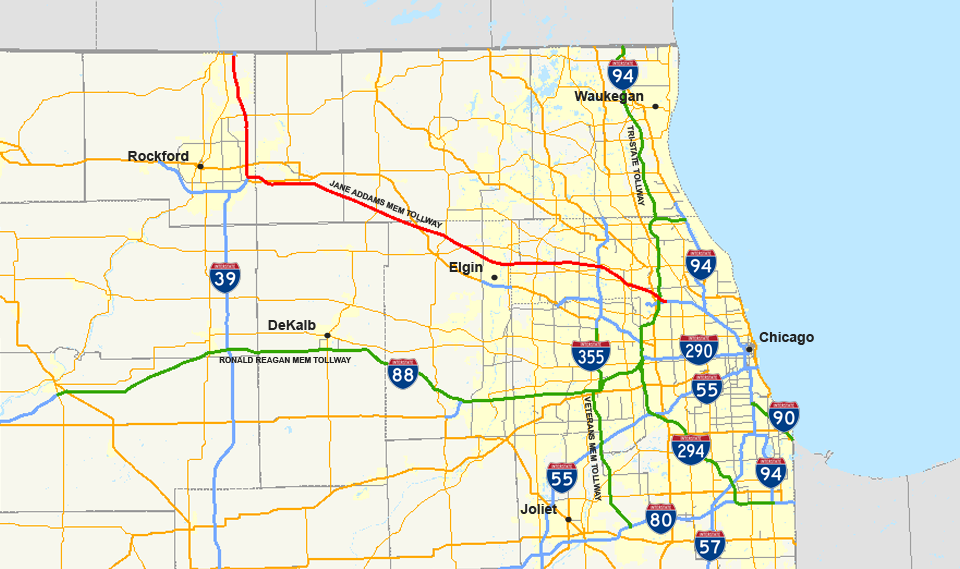
Jane Addams Memorial Tollway


Formerly the Northwest Tollway 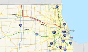
Route information Maintained by ISTHA Length: 79 mi (127 km) Existed: 1958 – present Major junctions West end:  IL 75 in South Beloit
East end: 
 I-90 / I-190 in Chicago
Highway system Main route of the Interstate Highway System
Main • Auxiliary • BusinessThe Jane Addams Memorial Tollway in Illinois is a 79-mile (127 km) segment of Interstate 90 from Interstate 190 in far northwest Chicago to Illinois Route 75, one mile (1.6 km) south of the Wisconsin state line. For 16 miles (26 km), Interstate 90 is concurrent with Interstate 39 and U.S. Route 51. The highway is named after Jane Addams, Nobel Peace Prize winner and founder of the Settlement House movement in the United States.
The tollway was built in the late 1950s and early 1960s from the O'Hare area (at the Tri-State Tollway) to the WI line north of Rockford. The route is signed as I-90 on its entire length. From the Rockford Curve to the last exit in IL (IL-75), US-51 and I-39 also run with the Tollway.
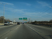
East of Interstate 190, Interstate 90 merges into the Kennedy Expressway.
Prior to September 7, 2007, the tollway was known as the Northwest Tollway.[1][2]
Contents
Route description
The Jane Addams Tollway contains 6 lanes (3 each direction) from its Northern terminus at Rockton Road, just south of the Wisconsin State Line, until its interchange with Interstate 39 at Cherry Valley. East of the Interstate 39 interchange, the tollway is 4 lanes (2 each direction) until its interchange with Randall Road at Elgin. From Elgin until its Eastern terminus, where it merges into the Kennedy Expressway, the tollway is 6 lanes (3 each direction).
Toll barriers
There are four mainline toll barriers in each direction with two split plazas and two full plazas. The barriers are located around the O'Hare International Airport area (River Road eastbound and Devon Avenue westbound), in Elgin, near Marengo (Eastbound), in Belvidere (Westbound), and in South Beloit. Interstate 39 travelers exiting/entering at Rockford paid at the Cherry Valley toll plaza, but that toll plaza has been decommissioned southbound in 2003 and northbound in 2004 in due to traffic congestion.[3] In Feb. 2006, the Marengo Westbound and the Belvidere Eastbound tolls were removed. Two two toll plazas near O'Hare and the one in Elgin each charge cash tolls of 80 cents (as of January 1, 2005) and I-Pass tolls of 40 cents for a 2-axle passenger vehicle. The South Beloit toll plaza near the Illinois and Wisconsin state line is $1.00 (50 cents for I-Pass users). Eastbound traffic does not pay a toll at Belvidere because of the removal of the Eastbound Belvidere plaza, but pays $1.60 at Marengo (I-Pass users pay $0.80). On the other hand, Westbound traffic pays no toll at Marengo but pays $1.60 at Belvidere (I-PASS users pay $0.80). This change was done to accommodate open road tolling construction. Originally, a ticket system was used to compute tolls on the segment between Beloit and Elgin with each driver receiving a Hollerith card upon entering and paying upon exiting, but it was replaced with a cash barrier system in the late 1970s. It was the only portion of the Illinois Tollways to use a ticket system. Remnants of the old system can still be seen at several interchanges on the system including at the State St. US Bus. Hwy 20 exit near Rockford.
The Jane Addams Tollway is maintained by the Illinois State Toll Highway Authority.
Oases
There are two oases on the Jane Addams Tollway—one at Belvidere, and one in Des Plaines near O'Hare. Both are over-highway oases. A motorist was struck by flying debris and killed on 7 December 2009 at the Belvidere Oasis following an explosion at a nearby crystal factory. There is also a welcome center south of Beloit, WI that is located on the IDOT portion of the highway between the border with Wisconsin and Illinois Tollway control.
Golden Corridor
From O'Hare to Huntley, the region around the Jane Addams Tollway is sometimes referred to as the "Golden Corridor", due to the proximity of commercial and business activity located along the corridor in Northwest Suburban Chicago. Several Fortune 500 companies, large malls, hotels, entertainment and exhibition facilities, restaurants, and retailers are located along the corridor, providing a "gold" mine of profit to communities along the Golden Corridor.
History
The 76 mile portion of between O'Hare International airport and the Wisconsin state line opened on August 20, 1958.[4] Prior to the opening, the first vehicle to officially travel the new roadway was a covered wagon navigated by local resident John Madsen who took 5 days to make the journey.[5]
Exit list
County Location Plaza
#[6]Mile
[6][7]Destinations Notes Winnebago South Beloit 0  US 51 north / IL 75 west – South Beloit
West end of US 51 overlap; signed as exit 1 Rockton 3 Northern end of Jane Adams Tollway - Rockton Road – Roscoe Signed as exit 3, southbound traffic enters the Tollroad after this exit. 1 3.5 South Beloit Toll Plaza Rockford 4 9.2  IL 173 – Machesney Park
Toll at southbound entrance and northbound exit 2 13 East Riverside Boulevard – Loves Park Toll at southbound entrance and northbound exit 15.5 
 US 20 Bus. (State Street)
17.5  I-39 south / US 51 south to US 20 – Rockford
East end of I-39/US 51 overlap Boone Belvidere 21 Irene Road Westbound exit only 5 23.5 Belvidere Toll Plaza (westbound) 24.5 Belvidere Oasis 25 Genoa Road – Belvidere McHenry Riley 7 38 Marengo-Hampshire Toll Plaza (eastbound) Kane Hampshire 43 US 20 – Marengo, HampshireHuntley 46.5  IL 47 – Woodstock
Westbound exit and eastbound entrance Elgin 8 52.5 Randall Road Toll at eastbound exit and westbound entrance 9 54 Elgin Toll Plaza 11 55  IL 31
IL 31Cook 13 56  IL 25
IL 25Hoffman Estates 14A 58 Beverly Road Westbound exit and eastbound entrance, toll at westbound exit 14 60  IL 59
IL 59Toll at exits 10 62.5 Barrington Road Westbound exit and eastbound entrance, toll at westbound exit Schaumburg 12 66 Roselle Road Westbound exit and eastbound entrance, toll at westbound exit 15 68.5 
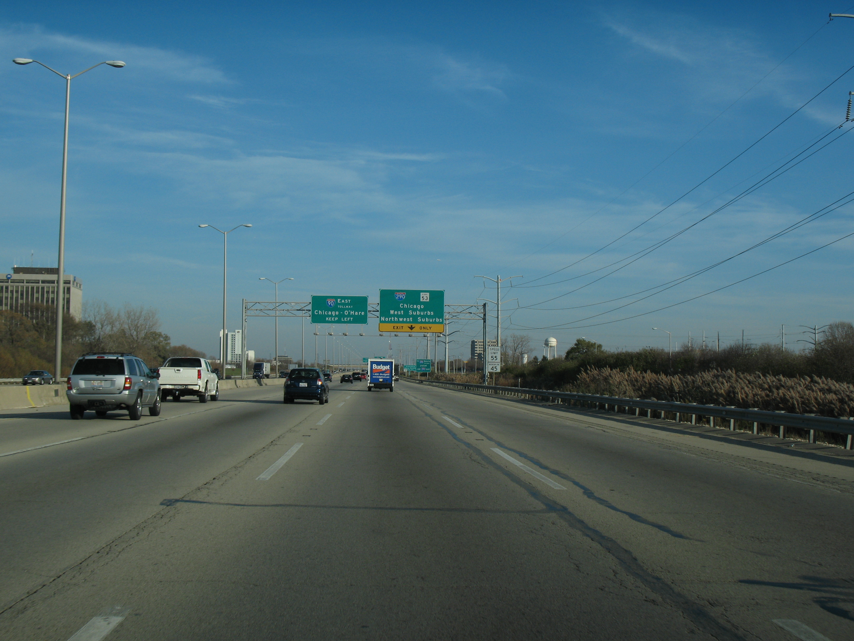
 I-290 east (Eisenhower Expressway) / IL 53 – Chicago, West Suburbs, Northwest Suburbs
Toll at eastbound exit Arlington Heights 18 71 Arlington Heights Road Toll at eastbound exit Des Plaines 74 Elmhurst Road Westbound exit and eastbound entrance 74.5 Des Plaines Oasis 76.5  IL 72 / Lee Street
Westbound exit and eastbound entrance Rosemont 17 77 Devon Avenue Toll Plaza (westbound) 77.5 IL 72 / Devon Avenue (6400 North)Westbound entrance only 77.5  I-294 south (Tri-State Tollway) / I-190 west (Kennedy Expressway) – Indiana, O'Hare Airport
Eastbound exit and westbound entrance 78 I-294 north (Tri-State Tollway) – Milwaukee19 78.5 River Road Toll Plaza (eastbound) Chicago 79 I-90 east (Kennedy Expressway) – ChicagoEastbound exit and westbound entrance References
- ^ Ryan, Joseph (2007-09-07). "Northwest Tollway renamed for reformer Addams". http://www.dailyherald.com/story/?id=33757. Retrieved 2007-09-08.
- ^ Illinois General Assembly (2007-05-22). "Full text of HJR0019". http://www.ilga.gov/legislation/fulltext.asp?GAID=9&SessionID=51&GA=95&DocTypeID=HJR&DocNum=19&LegID=30143&SpecSess=&Session=. Retrieved 2007-09-08.
- ^ "Cherry Valley Interchange Press Release". Nov 12, 2009. http://www.illinoistollway.com/portal/page?_pageid=54,2491497&_dad=portal&_schema=PORTAL. Retrieved 2009-11-13.
- ^ "N. W. Tollway Opens Aug. 20 at Ceremony". Chicago Daily Tribune. June 30, 1958. http://pqasb.pqarchiver.com/chicagotribune/access/519671322.html?dids=519671322:519671322&FMT=ABS&FMTS=ABS:AI&type=historic&date=Jun+30%2C+1958&author=&pub=Chicago+Tribune&desc=N.+W.+TOLLWAY+OPENS+AUG.+20+AT+CEREMONY&pqatl=google. Retrieved April 18, 2010.
- ^ "First tollway vehicle to be covered wagon". The Milwaukee Journal. August 11, 1958. http://news.google.com/newspapers?id=pAokAAAAIBAJ&sjid=oiUEAAAAIBAJ&pg=7508,55220&dq=. Retrieved April 18, 2010.
- ^ a b Illinois State Toll Highway Authority, System Map, November 2007
- ^ Mile markers are to be reversed, starting with 0 at the Wisconsin border, to conform to the numbering on other portions of I-90. Jon Hilkevitch (October 19, 2009). "Illinois tollways: New markers to be posted every quarter-mile instead of half-mile". Chicago Tribune. http://archives.chicagotribune.com/2009/oct/19/travel/chi-getting-around-19oct19.
External links
- Illinois Tollway official site
- Description and history from Richard Carlson's Illinois Highways
- Historic, Current & Average Travel Times For The Jane Addams Tollway
Toll highways in Illinois Highways Jane Addams Memorial Tollway (I-39/I-90) • Tri-State Tollway (I-294/80/94) • Ronald Reagan Memorial Tollway (I-88) • Veterans Memorial Tollway (I-355)Miscellaneous Expressways in the Chicago area 
Stevenson Expressway 
Interstate 57 
Interstate 65 


Kingery Expressway | Borman Expressway
Tri-State Tollway 
Ronald Reagan Memorial Tollway Jane Addams Memorial Tollway | Chicago Skyway | Indiana Toll Road Dan Ryan Expressway
Interstate 190 | Kennedy Expressway Edens Spur | Edens Expressway | Bishop Ford Freeway Eisenhower Expressway 
Veterans Memorial Tollway Elgin Bypass 
Lake Shore Drive | Skokie Highway Illinois Route 53 
Kingery Highway 
Amstutz Expressway 
Illinois Route 394 
Elgin–O'Hare Expressway 
Cline Avenue Proposed Expressways 
Crosstown Expressway Fox Valley Freeway Illiana Expressway Prairie Parkway O'Hare Ring Road I-Pass • Illinois Tollway oasis • Illinois State Toll Highway Authority Categories:- Toll roads in Illinois
- Tolled sections of Interstate Highways
- Expressways in the Chicago area
- U.S. Route 20
- Interstate 90


Wikimedia Foundation. 2010.