- Kirkwood, California
Infobox Settlement
official_name = Kirkwood, California
settlement_type = CDP
imagesize =
image_caption =
image_
imagesize =
image_caption =
image_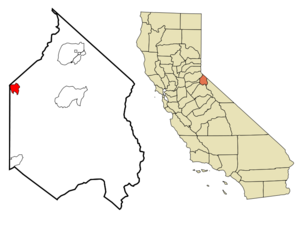
mapsize = 250x200px
map_caption = Location in Alpine County and the state ofCalifornia
mapsize1 =
map_caption1 =
subdivision_type = Country
subdivision_type1 = State
subdivision_type2 = County
subdivision_name =United States
subdivision_name1 =California
subdivision_name2 = Alpine
government_type =
leader_title = N/A
leader_name =
leader_title1 = State Senate
leader_name1 =Dave Cox (R)
leader_title2 = State Assembly
leader_name2 =Ted Gaines (R)
leader_title3 = U. S. Congress
leader_name3 =Dan Lungren (R)
established_date =
area_magnitude =
area_total_km2 = 8.2
area_total_sq_mi = 3.1
area_land_km2 = 5.7
area_land_sq_mi = 2.2
area_water_km2 = 2.5
area_water_sq_mi = 0.9
elevation_ft = 7690
elevation_m = 2344
population_as_of = 2000
population_footnotes =
population_total = 96
population_metro =
population_density_km2 = 11.7
population_density_sq_mi = 31
timezone = Pacific (PST)
utc_offset = -8
latd = 38 |latm = 41 |lats = 18 |latNS = N
longd = 120 |longm = 3 |longs = 19 |longEW = W
timezone_DST = PDT
utc_offset_DST = -7
postal_code_type =ZIP code
postal_code = 95646
area_code = 209
blank_name = FIPS code
blank_info = 06-38646
blank1_name = GNIS feature ID
blank1_info = 0262202
footnotes =
website =Kirkwood is a
census-designated place in Alpine County,California ,United States . The population was 96 at the 2000 census. Kirkwood's main attraction is theKirkwood Mountain Resort . The town is accessible by State Route 88. Kirkwood is within theEldorado National Forest .History
Zack Kirkwood , acattle rancher who had settled in the area, opened aninn , named Kirkwood's, in1863 with the opening of the Amador/Nevada Wagon Toll Road, the primary route through the Sierra Nevada Mountains. The following year, Alpine County was created and the redrawing of the county borders placed the inn at the convergence of Alpine, El Dorado, and Amador counties (the borders were later changed so the inn is no longer in El Dorado County, but the original signpost marking the intersection of the three is still in the building). Eventually, the inn became a fashionable summer resort.After Zack's death, the inn stayed in the family and continued to operate until
1966 , when it was sold to an investment group, who then converted it into the present-day Kirkwood Mountain Resort.The original building (still standing) is registered as
California Historical Landmark #40.Geography
According to the
United States Census Bureau , the CDP has a total area of 3.2square mile s (8.2km² ), of which, 2.2 square miles (5.7 km²) of it is land and 0.9 square miles (2.5 km²) of it (30.06%) is water.Demographics
As of the
census GR|2 of 2000, there were 96 people, 19 households, and 4 families residing in the CDP. Thepopulation density was 43.5 people per square mile (16.8/km²). There were 82 housing units at an average density of 37.1/sq mi (14.3/km²). The racial makeup of the CDP was 87.50% White, 2.08% Native American, 2.08% Asian, 1.04% Pacific Islander, and 7.29% from two or more races. 5.21% of the population were Hispanic or Latino of any race.There were 19 households out of which 5.3% had children under the age of 18 living with them, 21.1% were married couples living together, and 78.9% were non-families. 5.3% of all households were made up of individuals and 5.3% had someone living alone who was 65 years of age or older. The average household size was 5.05 and the average family size was 2.75.
In the CDP the population was spread out with 7.3% under the age of 18, 62.5% from 18 to 24, 24.0% from 25 to 44, 5.2% from 45 to 64, and 1.0% who were 65 years of age or older. The median age was 22 years. For every 100 females there were 255.6 males. For every 100 females age 18 and over, there were 256.0 males.
The median income for a household in the CDP was $46,250, and the median income for a family was $0. Males had a median income of $17,917 versus $11,250 for females. The
per capita income for the CDP was $14,853. There were no families and 47.9% of the population living below thepoverty line , including 0.0% of those under 18 and 0.0% of those over 64.References
External links
* [http://www.kirkwood.com Kirkwood Mountain Resort]
References
* [http://www.kirkwood.com/summer/kwlegacy1.html Pioneer Zack Kirkwood Was First To Tame This Frontier Mountain Wilderness]
Wikimedia Foundation. 2010.