- California State Route 88
Infobox road
state=CA
type=SR
route=88
section=388
maint=Caltrans 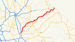
length_mi=122
length_round=0
length_ref= [ [http://www.dot.ca.gov/hq/structur/strmaint/brlog2.htm January 1, 2006 California Log of Bridges on State Highways] ]
direction_a=West
terminus_a=jct|state=CA|SR|99 in Stockton
junction=jct|state=CA|SR|49 in Jackson
jct|state=CA|SR|89 nearLake Tahoe
direction_b=East
terminus_b=jct|state=NV|SR|88 towardsCarson City, NV
previous_type=SR
previous_route=87
next_type=SR
next_route=89State Route 88 is a California State Highway that travels in an east-west direction, from Stockton through the Sierra Nevada Mountains, and ending at the border with
Nevada , whereupon it becomes State Route 88, eventually terminating at U.S. Route 395. Route 88 is one of only three routes to continue with the same route number after crossing into Nevada, the others being Routes 28 and 266.Unlike other two-lane California highways through the mountains (Routes 4, 108 and 120), Route 88 stays open through winter, except during the worst
snowstorm s, making it the third major route through the mountains, after Interstate 80 and U.S. Route 50. In fact, Route 88 over theCarson Pass is designated as Alternate U.S. 50, such that it may be used duringflood s of theAmerican River Canyon.A portion of Route 88 (from Antelope Springs to the border) started as the Amador/Nevada Wagon Route, a
toll road completed in1862 , which was a major thoroughfare through the mountains, as California senttimber , food, and particularlygold to the east during the Civil War. Completion of theFirst Transcontinental Railroad in 1869 greatly decreased traffic on the wagon road.This route is part of the
California Freeway and Expressway System [http://www.leginfo.ca.gov/cgi-bin/displaycode?section=shc&group=00001-01000&file=250-257 CA Codes (shc:250-257)] ] and is eligible for the State Scenic Highway System [http://www.leginfo.ca.gov/cgi-bin/displaycode?section=shc&group=00001-01000&file=260-284 CA Codes (shc:260-284)] ] .Points of interest
Listed in order from west to east.
*California Historical Landmark #995, the Trail of the1844 John C. Frémont Expedition, at the northwest corner of theCalaveras River (postmile SJ 6.09)
* Clinton (CHL #37), on Clinton Rd., south of the highway, in Pine Grove—Clinton was the center of aplacer mining community during the1850s and ofquartz mining as late as the1880s . This town once decided Amador County elections as its votes were always counted last.
* Irishtown (CHL #38), at the intersection of Pine Grove Wieland Rd. in Pine Grove—This was an important stopping place for emigrants on their way to the southern mines. The first white settlers on this spot found it a "city ofwigwam s," and hundreds of mortars in the rocks testify that this was a favorite Indian camping ground.
*Mount Zion State Park , Pine Grove
*Indian Grinding Rock State Historic Park , Pine Grove
*Eldorado National Forest , Amador Ranger Station, Pioneer
* Maiden's Grave (CHL #28), burial place of Rachel Melton (d.1850 ), a young girl who died while traveling to California via covered wagon (postmile AMA 61.3)
* The Old Emigrant Road was a long loop around the Silver Lake basin, starting fromCaples Lake and reaching an elevation of 9,640 feet (2,938 m) at one place. This difficult portion of the road was used by thousands of vehicles from 1848 to1863 , when a better route was blasted out of the face of the cliff at Carson Spur (the present highway route). There are two markers. One (CHL #662) is at the intersection of Mud Lake Rd (postmile AMA 63.1). The second marker (CHL #661) is at postmile ALP 2.4, at Caples Lake.
*Kirkwood Mountain Resort , Kirkwood
* Kirkwood's (CHL #40), a resort, stage station, and post office originally built byZack Kirkwood in1864 . The building straddles the Alpine–Amador county line.
* TheKit Carson Marker (CHL #315, postmile ALP 5.2), at the summit ofCarson Pass , marks where Carson carved his name into a tree in 1844 while guiding John C. Frémont through the Sierra Nevada. The original can be found atSutter's Fort , Sacramento.
* On some large rocks near Carson Pass, a group of pioneers inscribed their names and the emblem of theIndependent Order of Odd Fellows in1849 (CHL #378, postmile ALP 5.3).Major intersections
:"Note: Except where prefixed with a letter,
postmile s were measured in 1964, based on the alignment as it existed at that time, and do not necessarily reflect current mileage. The numbers reset at county lines; the start and end postmiles in each county are given in the county column."External links
* [http://www.westcoastroads.com/california/ca-088.html WestCoast Roads: State Route 88]
* [http://www.dot.ca.gov/hq/roadinfo/sr88 Caltrans: Route 88 highway conditions]
* [http://www.cahighways.org/081-088.html#088 California Highways: State Route 88]
* [http://www.interstate80.info/88index.html: Eric Buchanan's Highway 88 Photos]References

Wikimedia Foundation. 2010.