- Chalsa, India
-
Chalsa — town — Coordinates 26°53′N 88°47′E / 26.88°N 88.78°ECoordinates: 26°53′N 88°47′E / 26.88°N 88.78°E Country India State West Bengal District(s) Jalpaiguri Time zone IST (UTC+05:30) Area
• 163 metres (535 ft)
Chalsa (Bengali: চালসা) is a small town situated just on the foot of the Himalayas in the Duars in Jalpaiguri district in West Bengal. This small town is surrounded by hills, tea gardens, rivers and forests. One part of the town is surrounded by Gorumara National Park and other part with Chapramari Wildlife Sanctuary. This small town was known as Queen of Duars in British India. Nearby forests are residence of a good collection of elephants and rhinos. It is situated on the way towards Birpara or Alipurduar from Siliguri via Malbazar. It takes around 1.5 hours from Siliguri both on road and railways. It is 60 km from Bagdogra airport.
Contents
Geography
Chalsa is located at 26°53′N 88°47′E / 26.88°N 88.78°E.[1] It has an average elevation of 163 metres (535 feet). It is the headquarters of the Matiali community development block under the Malbazar subdivision of the Jalpaiguri district.[2]
Transport
Siliguri is the best starting point. Siliguri is connected by air (Bagdogra) from New Delhi, Guwahati, Chennai and Kolkata and by rail (New Jalpaiguri) from Delhi, Guwahati, Kolkata. Siliguri is about 10 hours by road from Kolkata. From Siliguri, Chapramari Sanctuary and Gorumara National Park are an hour and half away. And Chalsa is surrounded by these two forests. Road and rail transport are available choices. The National Highway is in very good condition and driving is comfortable.
Tourism
Various resorts and lodges around Gorumara. The Forest department has two bunglows each at Chapramari and Gourmara. There should be prior booking to avail these bunglows. There are also many cottages, resorts all around Garumara national park. They are mainly at Chalsa, Lataguri and Dhupjhora. Book your places to stay prior to arrival.
References
- ^ Falling Rain Genomics, Inc - Rangpo
- ^ "Contact details of Block Development Officers". Jalpaiguri district. Panchayats and Rural Development Department, Government of West Bengal. http://wbdemo5.nic.in/html/asp/bdo_contact.asp?cd=DK. Retrieved 2008-12-26.
-
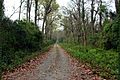
Jungle at Chalsa
-
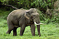
Resident elephants
-
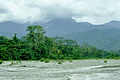
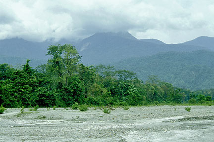
Hilly Chalsa
Jalpaiguri district topics General Baikunthapur Forest • Buxa Tiger Reserve • Chilapata Forests • Dooars • Gorumara National Park • Jaldapara Wildlife Sanctuary • Madhu Tea Estate • North Bengal • Terai • Western DuarsSubdivisions Locations
other than cities and townsMunicipalities Community development blocks Rivers Transport Lok Sabha constituencies Vidhan Sabha constituencies Kumargram • Kalchini • Alipurduars • Falakata • Madarihat • Nagrakata • Dhupguri • Maynaguri • Mal • Dabgram-Phulbari • Jalpaiguri • RajganjFormer Vidhan Sabha constituencies KrantiSee also Cities and towns in Jalpaiguri district • People from Jalpaiguri district • Villages in Jalpaiguri districtOther districts Bankura • Bardhaman • Birbhum • Cooch Behar • Dakshin Dinajpur • Darjeeling • Hooghly • Howrah • Kolkata • Malda • Murshidabad • Nadia • North 24 Parganas • Paschim Medinipur • Purba Medinipur • Purulia • South 24 Parganas • Uttar DinajpurCategories:- Cities and towns in Jalpaiguri district


Wikimedia Foundation. 2010.