- Oleni
-
For a municipality in the prefecture of Achaea, see Olenia. There is also Oleni Island and Oleni in Russia.
Oleni
ΩλένηLocation 
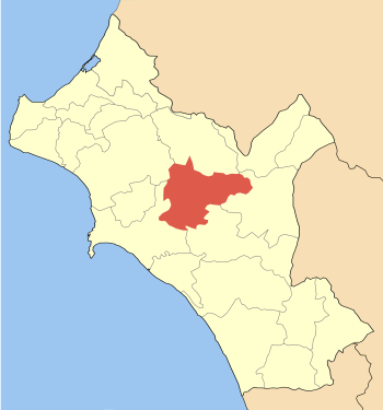
 Oleni
OleniCoordinates 37°44′N 21°33′E / 37.733°N 21.55°ECoordinates: 37°44′N 21°33′E / 37.733°N 21.55°E Location within the peripheral unit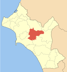
Government Country: Greece Region: West Greece Regional unit: Elis Municipality: Pyrgos Population statistics (as of 2001) Municipal unit - Population: 9,026 Other Time zone: EET/EEST (UTC+2/3) Elevation (center): 240 m (787 ft) Postal: 270 64 Telephone: 26210 Auto: ΗΑ Oleni (Greek: Ωλένη) is a village and a former municipality in Elis, West Greece, Greece. Since the 2011 local government reform it is part of the municipality Pyrgos, of which it is a municipal unit.[1] The seat of the municipality was in Karatoula. It is located about 20 km S of Simopoulo, NE of Pyrgos, SE of Amaliada, E of Vounargo and NW of Olympia. The largest community is Goumero. In the 19th century, the municipality was known as Olenas.
Contents
Subdivisions
The municipal unit Oleni is subdivided into the following communities (constituent villages in brackets):
- Agia Anna
- Arvaniti
- Charia
- Cheimadio
- Goumero
- Karatoula (Karatoula, Kleidereika, Marmara)
- Karya (Karya, Varvarina, Sitochori)
- Klindia
- Koutsochera
- Lanthi (Lanthi, Moni Kremastis)
- Latzoi (Latzoi, Agios Georgios, Almyriki, Grammatikos)
- Magoula (Magoula, Katsomaliareika)
- Mouzaki
- Oleni
- Pefki
- Sopi
Historical population
Year Village Municipality 1981 594 - 1991 964 7,560 2001 981 9,026 Mayors
- Dimosthenos Dogkas (1875-1881)
- Dimisthenos Dogkas 1887-several years later
- There were no mayors between 1912 and the mid to late 1990s.
History
The place dates back to the ancient times like a town which called "Amphidolis".
Str. 8.3.10 (Weight: 0.2) _ [ 10 ] τὸ δ' Ἀλείσιον ἔστι τὸ νῦν Ἀλεσιαῖον, χώρα περὶ τὴν Ἀμφιδολίδα, ἐν ᾗ καὶ κατὰ μῆνα ἀγορὰν συνάγουσιν οἱ περίοικοι: κεῖται δὲ ἐπὶ τῆς ὀρεινῆς ὁδοῦ τῆς ἐξ Ἤλιδος εἰς Ὀλυμπίαν: πρότερον δ' ἦν πόλις τῆς Πισάτιδος, ἄλλοτ' ἄλλως τῶν ὅρων ἐπαλλαττόντων διὰ τὰς τῶν ἡγεμόνων μεταβολάς:
<<... Aleisium is the present Alesiaeum, a territory in the neighbourhood of Amphidolis, in which the people of the surrounding country hold a monthly market. It is situated on the mountain-road that runs from Elis to Olympia. In earlier times it was a city of Pisatis, for the boundaries have varied at different times on account of the change of rulers. The poet also calls Aleisium "Hill of Aleisium," when he says: "until we caused our horses to set foot on Buprasium, rich in wheat, and on the Olenian Rock, and of Aleisium where is the place called Hill" (we must interpret the words as a case of hyperbole, that is, as equivalent to "and where is the place called Hill of Aleisium"). Some writers point also to a river Aleisius... >>
The Aleisius River is near Karatoula and much of the area and the municipality are forested while the remainder of the land has some farmland, rivers, and streams.
References
- ^ Kallikratis law Greece Ministry of Interior (Greek)
External links
- Municipality Of Oleni Web Site
- Panoleniakos Karatoula Football Club
- Karatoula Fans Of Panathinaikos Athletic Club
North: Pineia West: Iardanos Oleni East: Foloi? South: Pyrgos See also
- Communities of Ilia
Municipal unit of Iardanos Municipal unit of Oleni Municipal unit of Pyrgos Municipal unit of Volakas Agridi · Alfeiousa · Anemochori · EpitalioCategories:- Populated places in Elis

Wikimedia Foundation. 2010.